Estimated Value: $515,000 - $599,000
3
Beds
2
Baths
1,648
Sq Ft
$341/Sq Ft
Est. Value
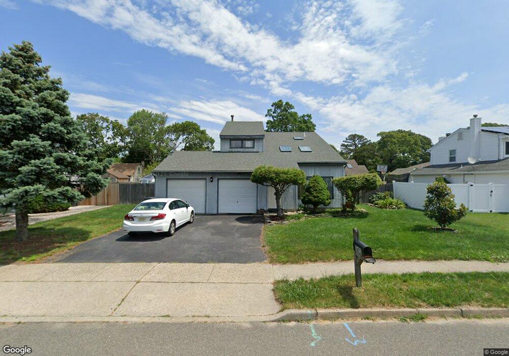
About This Home
This home is located at 543 Dorothy Place, Brick, NJ 08723 and is currently estimated at $562,518, approximately $341 per square foot. 543 Dorothy Place is a home located in Ocean County with nearby schools including Osbornville Elementary School, Lake Riviera Middle School, and Brick Township High School.
Ownership History
Date
Name
Owned For
Owner Type
Purchase Details
Closed on
Oct 13, 2004
Sold by
Kemper Thomas A and Kemper Carmen
Bought by
Laffosses Jose and Laffosses Karla
Current Estimated Value
Home Financials for this Owner
Home Financials are based on the most recent Mortgage that was taken out on this home.
Original Mortgage
$200,000
Outstanding Balance
$98,651
Interest Rate
5.71%
Mortgage Type
Fannie Mae Freddie Mac
Estimated Equity
$463,867
Create a Home Valuation Report for This Property
The Home Valuation Report is an in-depth analysis detailing your home's value as well as a comparison with similar homes in the area
Home Values in the Area
Average Home Value in this Area
Purchase History
| Date | Buyer | Sale Price | Title Company |
|---|---|---|---|
| Laffosses Jose | $318,500 | Madison Title Agency Llc |
Source: Public Records
Mortgage History
| Date | Status | Borrower | Loan Amount |
|---|---|---|---|
| Open | Laffosses Jose | $200,000 |
Source: Public Records
Tax History Compared to Growth
Tax History
| Year | Tax Paid | Tax Assessment Tax Assessment Total Assessment is a certain percentage of the fair market value that is determined by local assessors to be the total taxable value of land and additions on the property. | Land | Improvement |
|---|---|---|---|---|
| 2025 | $7,421 | $287,300 | $130,300 | $157,000 |
| 2024 | $7,053 | $287,300 | $130,300 | $157,000 |
| 2023 | $6,961 | $287,300 | $130,300 | $157,000 |
| 2022 | $6,961 | $287,300 | $130,300 | $157,000 |
| 2021 | $6,815 | $287,300 | $130,300 | $157,000 |
| 2020 | $6,729 | $287,300 | $130,300 | $157,000 |
| 2019 | $6,617 | $287,300 | $130,300 | $157,000 |
| 2018 | $6,464 | $287,300 | $130,300 | $157,000 |
| 2017 | $6,289 | $287,300 | $130,300 | $157,000 |
| 2016 | $6,257 | $287,300 | $130,300 | $157,000 |
| 2015 | $6,094 | $287,300 | $130,300 | $157,000 |
| 2014 | $6,045 | $287,300 | $130,300 | $157,000 |
Source: Public Records
Map
Nearby Homes
- 0 Mantoloking Rd Unit 11584872
- 484 Bara St
- 507 Riverside Dr S
- 470 Mantoloking Rd
- 10 Riverside Dr W
- 474 Burnt Bark Rd
- 417 Mamie Dr
- 553 Kingfisher Cr
- 570 Mantoloking Rd
- 463 Mamie Dr
- 553 Kingfisher Cir
- 455 Mamie Dr
- 82 E View Dr
- 53 Country Club Ct
- 618 Leanora St
- 15 Hulse Landing Rd
- 00 Mantoloking Rd
- VZ0 Mantoloking Rd
- 621 Preston St
- 42 Arbutus Ave
- 541 Dorothy Place
- 545 Dorothy Place
- 495 Mohawk Dr
- 499 Mohawk Dr
- 501 Mohawk Dr
- 544 Dorothy Place
- 493 Mohawk Dr
- 539 Dorothy Place
- 542 Dorothy Place
- 502 Dorothy Place
- 547 Dorothy Place
- 496 Mohawk Dr
- 503 Mohawk Dr
- 500 Mohawk Dr
- 540 Dorothy Place
- 491 Mohawk Dr
- 537 Dorothy Place
- 495 W Briarcliff Dr
- 492 Dorothy Place
- 504 Dorothy Place