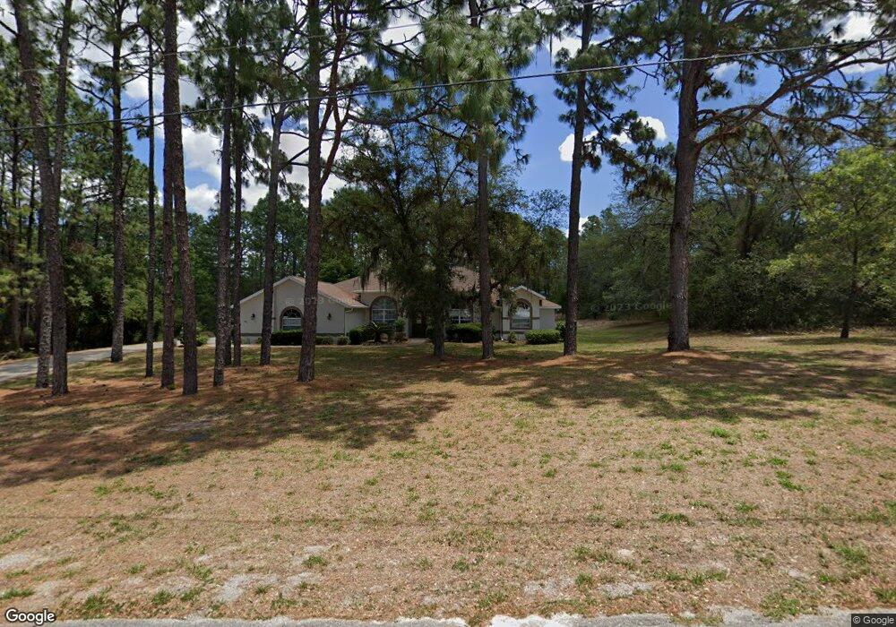
5431 N Range Way Beverly Hills, FL 34465
Estimated Value: $467,000 - $588,000
3
Beds
3
Baths
2,814
Sq Ft
$193/Sq Ft
Est. Value
About This Home
This home is located at 5431 N Range Way, Beverly Hills, FL 34465 and is currently estimated at $541,826, approximately $192 per square foot. 5431 N Range Way is a home located in Citrus County with nearby schools including Central Ridge Elementary School, Crystal River High School, and Crystal River Middle School.
Ownership History
Date
Name
Owned For
Owner Type
Purchase Details
Closed on
Jul 31, 2009
Sold by
Holthaus Robert A and Holthaus Linda L
Bought by
Holthaus Robert A and Holthaus Linda Lou
Current Estimated Value
Purchase Details
Closed on
Jul 1, 2009
Bought by
Holthaus Robert A & Linda L Trustees
Purchase Details
Closed on
Feb 4, 2000
Sold by
Ross Norman F
Bought by
Holthaus Robert A and Holthaus Linda L
Create a Home Valuation Report for This Property
The Home Valuation Report is an in-depth analysis detailing your home's value as well as a comparison with similar homes in the area
Home Values in the Area
Average Home Value in this Area
Purchase History
| Date | Buyer | Sale Price | Title Company |
|---|---|---|---|
| Holthaus Robert A | -- | Attorney | |
| Holthaus Robert A & Linda L Trustees | $100 | -- | |
| Holthaus Robert A | $12,500 | Manatee Title Company Inc |
Source: Public Records
Tax History Compared to Growth
Tax History
| Year | Tax Paid | Tax Assessment Tax Assessment Total Assessment is a certain percentage of the fair market value that is determined by local assessors to be the total taxable value of land and additions on the property. | Land | Improvement |
|---|---|---|---|---|
| 2025 | $3,268 | $254,640 | -- | -- |
| 2024 | $3,191 | $247,464 | -- | -- |
| 2023 | $3,191 | $240,256 | $0 | $0 |
| 2022 | $2,988 | $233,258 | $0 | $0 |
| 2021 | $2,868 | $226,464 | $0 | $0 |
| 2020 | $2,771 | $288,800 | $23,390 | $265,410 |
| 2019 | $2,738 | $270,080 | $23,080 | $247,000 |
| 2018 | $2,714 | $264,329 | $21,050 | $243,279 |
| 2017 | $2,709 | $209,838 | $18,760 | $191,078 |
| 2016 | $2,738 | $205,052 | $17,340 | $187,712 |
| 2015 | $2,781 | $203,627 | $17,650 | $185,977 |
| 2014 | $2,845 | $202,011 | $21,090 | $180,921 |
Source: Public Records
Map
Nearby Homes
- 5432 N Pecos Terrace
- 5485 N Pecos Terrace
- 4930 W Pinto Loop
- 5527 N Sierra Terrace
- 5070 W Wichita Dr
- 4930 W West Pinto Loop
- 4091 W Pinto Loop
- 5807 N Bridle Terrace
- 5235 N Sonora Terrace
- 5621 N Flagstaff Ave
- 5338 W Corral Place
- 4881 W Phoenix Dr
- 4464 W Horseshoe Dr
- 4923 W Phoenix Dr
- 4395 W Alamo
- 5400 W Conestoga St
- 5932 N Flagstaff Ave
- 4757 W Casper Ln
- 5396 W Pine Ridge Blvd
- 4621 N Pink Poppy St W
- 4894 W Custer Dr
- 5469 N Range Way
- 5486 N Pecos Terrace
- 5470 N Range Way
- 4859 W Custer Dr
- 4984 W Custer Dr
- 4829 W Custer Dr
- 4633 W Custer Dr
- 4860 W Custer Dr
- 0 W Custer Dr
- 4928 W Custer Dr
- 4826 W Custer Dr
- 5513 N Range Way
- 5526 N Pecos Terrace
- 4977 W Custer Dr
- 5558 N Pecos Terrace
- 5594 N Pecos Terrace
- 5406 N Pecos Terrace
- 5559 N Pecos Terrace
- 5441 N Pecos Terrace