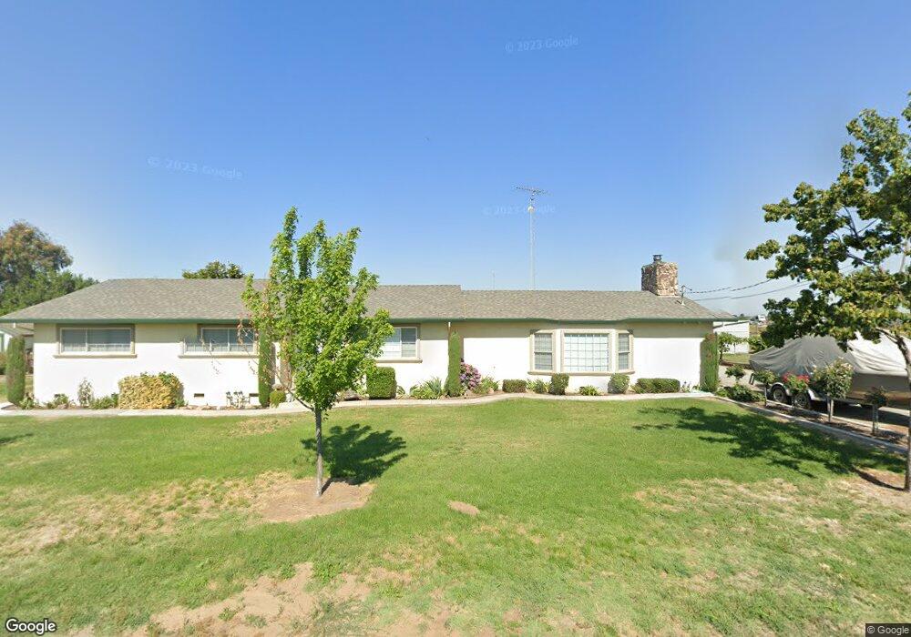
5431 S Commons Rd Turlock, CA 95380
Estimated Value: $510,000 - $643,000
3
Beds
2
Baths
1,898
Sq Ft
$308/Sq Ft
Est. Value
About This Home
This home is located at 5431 S Commons Rd, Turlock, CA 95380 and is currently estimated at $584,343, approximately $307 per square foot. 5431 S Commons Rd is a home located in Stanislaus County with nearby schools including Chatom Elementary School, Mountain View Middle School, and Marvin A. Dutcher Middle School.
Ownership History
Date
Name
Owned For
Owner Type
Purchase Details
Closed on
May 3, 2021
Sold by
Gonzalo Richard R
Bought by
Gonzalo Richard R and Gonzalo Lisa
Current Estimated Value
Purchase Details
Closed on
Nov 6, 1996
Sold by
Gonzalo and Arnola
Bought by
Gonzalo Richard R
Home Financials for this Owner
Home Financials are based on the most recent Mortgage that was taken out on this home.
Original Mortgage
$114,000
Interest Rate
7.66%
Mortgage Type
Purchase Money Mortgage
Create a Home Valuation Report for This Property
The Home Valuation Report is an in-depth analysis detailing your home's value as well as a comparison with similar homes in the area
Purchase History
We collect this data history from publicly available records. To have your information removed, we recommend requesting removal directly through your county’s website.
| Date | Buyer | Sale Price | Title Company |
|---|---|---|---|
| Gonzalo Richard R | -- | None Available | |
| Gonzalo Richard R | -- | Northern Counties Title Ins |
Source: Public Records
Mortgage History
We collect this data history from publicly available records. To have your information removed, we recommend requesting removal directly through your county’s website.
| Date | Status | Borrower | Loan Amount |
|---|---|---|---|
| Closed | Gonzalo Richard R | $114,000 |
Source: Public Records
Tax History
| Year | Tax Paid | Tax Assessment Tax Assessment Total Assessment is a certain percentage of the fair market value that is determined by local assessors to be the total taxable value of land and additions on the property. | Land | Improvement |
|---|---|---|---|---|
| 2025 | $2,426 | $231,875 | $84,365 | $147,510 |
| 2024 | $2,368 | $227,329 | $82,711 | $144,618 |
| 2023 | $2,370 | $222,873 | $81,090 | $141,783 |
| 2022 | $2,335 | $218,503 | $79,500 | $139,003 |
| 2021 | $2,298 | $214,220 | $77,942 | $136,278 |
| 2020 | $2,268 | $212,024 | $77,143 | $134,881 |
| 2019 | $2,232 | $207,868 | $75,631 | $132,237 |
| 2018 | $2,228 | $203,794 | $74,149 | $129,645 |
| 2017 | $2,155 | $199,799 | $72,696 | $127,103 |
| 2016 | $2,079 | $195,882 | $71,271 | $124,611 |
| 2015 | $2,067 | $192,941 | $70,201 | $122,740 |
| 2014 | $1,927 | $179,662 | $68,826 | $110,836 |
Source: Public Records
Map
Nearby Homes
- 4930 S Faith Home Rd
- 4701 S Faith Home Rd
- 6425 S Prairie Flower Rd
- 3725 W Simmons Rd
- 3601 W Simmons Rd
- 4207 W Linwood Ave
- 2406 S Walnut Rd
- 607 S Tegner Rd
- 0 Apn: 015-090-012-000 Unit 225130276
- 3924 Lander Ave
- 119 E Clausen Rd
- 209 E Clausen Rd
- 2625 W Main St
- 218 E Greenway Ave
- 3131 W Main St
- 19960 American Ave
- 19960 American Ave Unit 51
- 8698 N Privado Ct
- 0 1st St Unit 224093393
- 0 1st St Unit 224093409
- 5519 S Commons Rd
- 5407 S Commons Rd
- 5313 S Commons Rd
- 6051 Christofferson Rd
- 5637 Christofferson Rd
- 5512 Christofferson Rd
- 5725 Christofferson Rd
- 5706 Christofferson Rd
- 5500 Christofferson Rd
- 5201 S Commons Rd
- 5412 Christofferson Rd
- 5824 Christofferson Rd
- 5919 Christofferson Rd
- 5300 Christofferson Rd
- 5207 Christofferson Rd
- 5118 Christofferson Rd
- 5200 S Faith Home Rd
- 5019 Christofferson Rd
- 5202 S Faith Home Rd
- 5026 Christofferson Rd
Your Personal Tour Guide
Ask me questions while you tour the home.