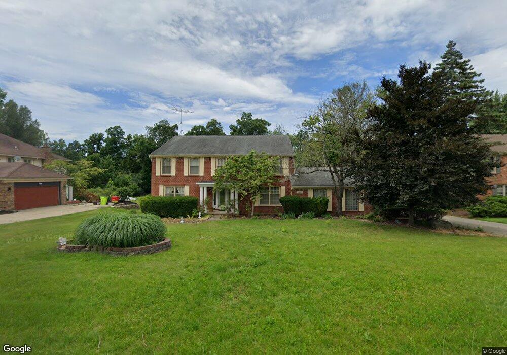
5432 Crispin Way Rd West Bloomfield, MI 48323
West Bloomfield Township NeighborhoodEstimated Value: $540,000 - $696,000
4
Beds
3
Baths
3,092
Sq Ft
$192/Sq Ft
Est. Value
About This Home
This home is located at 5432 Crispin Way Rd, West Bloomfield, MI 48323 and is currently estimated at $594,022, approximately $192 per square foot. 5432 Crispin Way Rd is a home located in Oakland County with nearby schools including Wylie E. Groves High School, West Maple Elementary School, and Berkshire Middle School.
Ownership History
Date
Name
Owned For
Owner Type
Purchase Details
Closed on
Jun 28, 1999
Sold by
Furusho Masaharu
Bought by
Shah Paresh M
Current Estimated Value
Purchase Details
Closed on
Nov 9, 1995
Sold by
Furusho Masaharu
Bought by
Furusho Masaharu
Purchase Details
Closed on
Jun 23, 1995
Sold by
Richards R Owen
Bought by
Furusho Masaharu
Home Financials for this Owner
Home Financials are based on the most recent Mortgage that was taken out on this home.
Original Mortgage
$120,000
Interest Rate
7.5%
Mortgage Type
New Conventional
Create a Home Valuation Report for This Property
The Home Valuation Report is an in-depth analysis detailing your home's value as well as a comparison with similar homes in the area
Home Values in the Area
Average Home Value in this Area
Purchase History
| Date | Buyer | Sale Price | Title Company |
|---|---|---|---|
| Shah Paresh M | $275,000 | -- | |
| Furusho Masaharu | -- | -- | |
| Furusho Masaharu | $243,000 | -- |
Source: Public Records
Mortgage History
| Date | Status | Borrower | Loan Amount |
|---|---|---|---|
| Previous Owner | Furusho Masaharu | $120,000 | |
| Closed | Shah Paresh M | -- |
Source: Public Records
Tax History
| Year | Tax Paid | Tax Assessment Tax Assessment Total Assessment is a certain percentage of the fair market value that is determined by local assessors to be the total taxable value of land and additions on the property. | Land | Improvement |
|---|---|---|---|---|
| 2025 | $5,842 | $232,420 | $65,750 | $166,670 |
| 2024 | $3,248 | $231,640 | $0 | $0 |
| 2022 | $3,117 | $222,900 | $65,750 | $157,150 |
| 2021 | $5,191 | $193,470 | $0 | $0 |
| 2020 | $2,955 | $188,110 | $51,950 | $136,160 |
| 2018 | $6,012 | $166,740 | $31,750 | $134,990 |
| 2015 | -- | $139,830 | $0 | $0 |
| 2014 | -- | $130,540 | $0 | $0 |
| 2011 | -- | $120,170 | $0 | $0 |
Source: Public Records
Map
Nearby Homes
- 5324 Fairway Ct
- 5622 Powder Horn Dr
- 2932 Constitution Ct
- 4941 Fairway Ridge Cir
- 5555 Bloomfield Glens Rd
- 4670 Cove Rd
- 6020 Northfield Rd
- 3095 Bloomfield Park Dr
- 3865 Stonecrest Rd
- 5352 W Doherty Dr
- 5815 Bloomfield Glens Rd
- 0000 Putnam Dr
- 5881 Naneva Ct
- 4458 Southmoor Ln
- 4768 Wendrick Dr
- 4974 Countryside Dr
- 3367 Lone Pine Rd
- 6121 Orchard Lake Rd Unit 102
- 3835 Lone Pine Rd Unit 300
- 2530 Worcester Rd
- 5424 Crispin Way Rd
- 5440 Crispin Way Rd
- 5416 Crispin Way Rd
- 5448 Crispin Way Rd
- 5297 Simpson Lake Rd
- 5297 Simpson Lake Rd Unit 80
- 5275 Simpson Lake Rd Unit Bldg-Unit
- 5275 Simpson Lake Rd Unit 79
- 5273 Simpson Lake Rd
- 5410 White Hall Cir
- 5301 Simpson Lake Rd
- 5435 Crispin Way Rd
- 5307 Simpson Lake Rd
- 5271 Simpson Lake Rd
- 5408 Crispin Way Rd
- 5456 Crispin Way Rd
- 5443 Crispin Way Rd
- 5313 Simpson Lake Rd Unit 83
- 5422 White Hall Cir
- 5409 Crispin Way Rd
Your Personal Tour Guide
Ask me questions while you tour the home.