
5433 Cinderford St NW Canton, OH 44718
Estimated payment $2,801/month
Highlights
- Deck
- No HOA
- Home Security System
- Lake Cable Elementary School Rated A
- 2 Car Attached Garage
- Laundry Room
About This Home
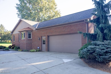
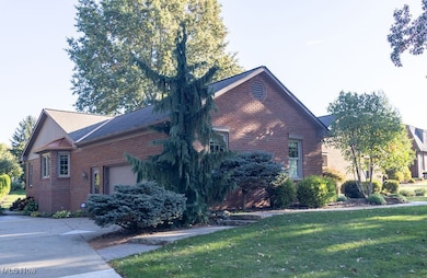
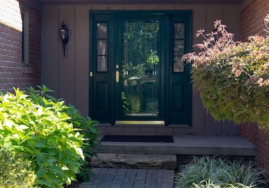
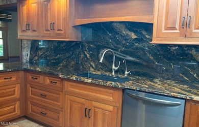
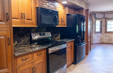
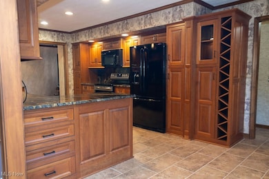
Are you ready to own a quality built 3BR,3.5BTH Brick Ranch in Jackson Township? if so, this centrally located home will amaze and convince you to own it. First floor features an updated kitchen, dining room, spacious family room, four season sunroom, three bedrooms, 2 full baths, and one-half bath, and laundry room. The lower level features a very nice, finished recreation room that is ideal for entertaining or possible spacious office or fitness room. Additional seller improvements include lawn irrigation system, newer roof, windows, doors and heat in sunroom, walk in shower with glass doors, tile floor, light fixtures and hardware on cabinets in master bath, newer windows throughout the rest of the home, glass block windows in the lower level, nature stone in garage and furnace replacement, deck and two steps on north side of exterior of the home and interior utility room where furnace is located all painted in October 2025. The deep pie shaped lot is ideal for recreational activities or gardening.
Listing Agent
Hayes Realty Brokerage Email: markserviceesber@gmail.com, 330-704-5044 License #700325409 Listed on: 10/17/2025
Home Details
Home Type
- Single Family
Est. Annual Taxes
- $5,090
Year Built
- Built in 1983
Lot Details
- 0.56 Acre Lot
- Pie Shaped Lot
Parking
- 2 Car Attached Garage
- Running Water Available in Garage
- Garage Door Opener
Home Design
- Brick Exterior Construction
- Frame Construction
- Asphalt Roof
Interior Spaces
- 1-Story Property
- Decorative Fireplace
- Finished Basement
- Sump Pump
- Laundry Room
Kitchen
- Range
- Microwave
- Dishwasher
- Disposal
Bedrooms and Bathrooms
- 3 Main Level Bedrooms
- 3.5 Bathrooms
Home Security
- Home Security System
- Fire and Smoke Detector
Outdoor Features
- Deck
Utilities
- Forced Air Heating and Cooling System
- Heating System Uses Gas
- Baseboard Heating
Community Details
- No Home Owners Association
- Amesbury Hills Subdivision
Listing and Financial Details
- Home warranty included in the sale of the property
- Assessor Parcel Number 01615399
Map
Home Values in the Area
Average Home Value in this Area
Tax History
| Year | Tax Paid | Tax Assessment Tax Assessment Total Assessment is a certain percentage of the fair market value that is determined by local assessors to be the total taxable value of land and additions on the property. | Land | Improvement |
|---|---|---|---|---|
| 2025 | -- | $121,420 | $27,970 | $93,450 |
| 2024 | -- | $121,420 | $27,970 | $93,450 |
| 2023 | $4,482 | $99,230 | $23,280 | $75,950 |
| 2022 | $4,481 | $99,230 | $23,280 | $75,950 |
| 2021 | $4,498 | $99,230 | $23,280 | $75,950 |
| 2020 | $4,060 | $83,800 | $20,060 | $63,740 |
| 2019 | $3,910 | $83,800 | $20,060 | $63,740 |
| 2018 | $3,930 | $83,800 | $20,060 | $63,740 |
| 2017 | $3,947 | $80,470 | $17,570 | $62,900 |
| 2016 | $3,974 | $80,470 | $17,570 | $62,900 |
| 2015 | $4,022 | $80,470 | $17,570 | $62,900 |
| 2014 | $1,792 | $73,400 | $16,000 | $57,400 |
| 2013 | $1,866 | $73,400 | $16,000 | $57,400 |
Property History
| Date | Event | Price | List to Sale | Price per Sq Ft |
|---|---|---|---|---|
| 10/17/2025 10/17/25 | For Sale | $450,000 | -- | $125 / Sq Ft |
Purchase History
| Date | Type | Sale Price | Title Company |
|---|---|---|---|
| Survivorship Deed | $239,000 | -- | |
| Deed | $250,000 | -- | |
| Deed | $200,000 | -- |
Mortgage History
| Date | Status | Loan Amount | Loan Type |
|---|---|---|---|
| Closed | $191,200 | Fannie Mae Freddie Mac | |
| Closed | $200,000 | Purchase Money Mortgage |
Source: MLS Now
MLS Number: 5165779
APN: 01615399
Disclaimer: Certain information contained herein is derived from information provided by parties other than Homes.com. All information provided is deemed reliable, but is not guaranteed to be accurate and should be independently verified.
![]() IDX information is provided exclusively for personal, non-commercial use, and may not be used for any purpose other than to identify prospective properties consumers may be interested in purchasing. Information is deemed reliable but not guaranteed.
IDX information is provided exclusively for personal, non-commercial use, and may not be used for any purpose other than to identify prospective properties consumers may be interested in purchasing. Information is deemed reliable but not guaranteed.
- 0 Hills And Dales Rd NW Unit 5138797
- 3722 Old Hickory Ave NW Unit 3A
- 4263 Belden Greens Cir NW
- 4120 Lochness Cir NW
- 2742 Dunkeith Dr NW
- 5879 Hawks Nest Cir NW
- 5877 Hawks Nest Cir NW
- 4720 Strouble Dr NW
- 5869 Hawks Nest Cir NW
- 5867 Hawks Nest Cir NW
- 5957 Century St NW
- 5853 Hawks Nest Cir NW
- 5851 Hawks Nest Cir NW
- 5848 Hawks Nest Cir NW
- 5846 Hawks Nest Cir NW
- 0 Bertram Ave NW Unit 5051955
- 5845 Hawks Nest Cir NW
- 5843 Hawks Nest Cir NW
- 5966 Hawks Nest Cir NW
- 6175 Bertram Ave NW
- 5186-5208 Everhard Rd NW
- 4384 Parkdale Ave NW
- 4389 Belden Greens Cir NW
- 6014 Marzilli St NW
- 4784 South Blvd NW
- 6331-6421 Groton St NW
- 4171 Foxhaven Ave NW
- 3640 Harris Ave NW
- 5902 Shakertown Dr NW
- 2601 Woodlawn Cir NW
- 6686 Hythe St NW
- 2740 Shaftesbury Dr NW
- 2000 Woodlawn Ave NW Unit 10
- 1804 Woodlawn Ave NW Unit 13
- 1804 Woodlawn Ave NW
- 5523 East Blvd NW
- 7036 Hills And Dales Rd NW
- 1835 Koran Ave NW Unit 1837 Koran Ave NW
- 1837 Koran Ave NW Unit 1837
- 4100 Independence Cir NW
