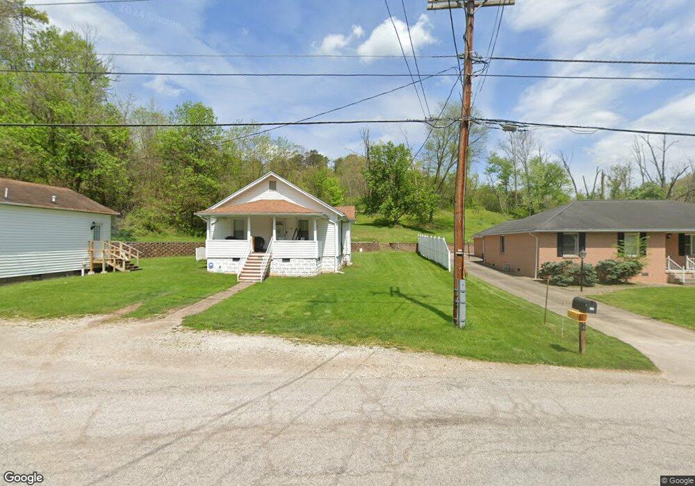
544 Austin Dr Saint Albans, WV 25177
Estimated Value: $138,000 - $176,000
3
Beds
1
Bath
1,184
Sq Ft
$126/Sq Ft
Est. Value
About This Home
This home is located at 544 Austin Dr, Saint Albans, WV 25177 and is currently estimated at $149,220, approximately $126 per square foot. 544 Austin Dr is a home located in Kanawha County with nearby schools including Anne Bailey Elementary School, Hayes Middle School, and Saint Albans High School.
Ownership History
Date
Name
Owned For
Owner Type
Purchase Details
Closed on
Jul 17, 2015
Sold by
Gunno Gary A
Bought by
Kimble Lynn R and Hamilton Nathan M
Current Estimated Value
Purchase Details
Closed on
Nov 5, 2004
Sold by
Thomas Paul I
Bought by
Gunno Gary A
Home Financials for this Owner
Home Financials are based on the most recent Mortgage that was taken out on this home.
Original Mortgage
$70,000
Interest Rate
5.71%
Mortgage Type
New Conventional
Create a Home Valuation Report for This Property
The Home Valuation Report is an in-depth analysis detailing your home's value as well as a comparison with similar homes in the area
Home Values in the Area
Average Home Value in this Area
Purchase History
| Date | Buyer | Sale Price | Title Company |
|---|---|---|---|
| Kimble Lynn R | $125,000 | -- | |
| Gunno Gary A | $70,000 | -- |
Source: Public Records
Mortgage History
| Date | Status | Borrower | Loan Amount |
|---|---|---|---|
| Previous Owner | Gunno Gary A | $70,000 |
Source: Public Records
Tax History Compared to Growth
Tax History
| Year | Tax Paid | Tax Assessment Tax Assessment Total Assessment is a certain percentage of the fair market value that is determined by local assessors to be the total taxable value of land and additions on the property. | Land | Improvement |
|---|---|---|---|---|
| 2024 | $743 | $58,930 | $8,890 | $50,040 |
| 2023 | $702 | $55,750 | $8,890 | $46,860 |
| 2022 | $661 | $52,450 | $8,890 | $43,560 |
| 2021 | $600 | $47,650 | $8,890 | $38,760 |
| 2020 | $600 | $47,650 | $8,890 | $38,760 |
| 2019 | $593 | $47,050 | $8,890 | $38,160 |
| 2018 | $529 | $47,230 | $8,890 | $38,340 |
| 2017 | $530 | $47,230 | $8,890 | $38,340 |
| 2016 | $531 | $47,220 | $8,880 | $38,340 |
| 2015 | $530 | $47,220 | $8,880 | $38,340 |
| 2014 | $399 | $36,120 | $8,880 | $27,240 |
Source: Public Records
Map
Nearby Homes
- 1333 Summer St
- 69 Central Ave
- 67 Central Ave
- 204 Winfield Rd
- 371 Martin St
- 13 Willis Ln
- 713 High St
- 113 Kentucky Ave
- 211 Stuart St
- 209 Stuart St
- 11500 Coal River Rd
- 12240 Coal River Rd
- 413 2nd Ave N
- 0 Hitching Post Ln
- 336 Birch St
- 418 Donna Dr
- 306 Kanawha Ave
- 1005 Dupont Ave
- 113 Kanawha Ave
- 1110 Benamati Ave
- 542 Austin Dr
- 0 Riverview Dr
- 536 Austin Dr
- 95 Riverview Dr
- 89 Riverview Dr
- 89 Riverview Dr
- 100 Riverview Dr
- 97 Riverview Dr
- 546 MacCorkle Ave
- 99 Riverview Dr
- 413 MacCorkle Ave SW
- 413 MacCorkle Ave SW
- 102 Riverview Dr
- 87 Riverview Dr
- 100 Benson Dr
- 101 Riverview Dr
- 178 Benson Dr
- 103 Riverview Dr
- 105 Riverview Dr
- 104 Riverview Dr