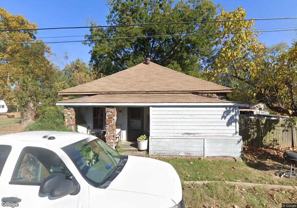
544 Carter St Mulberry, AR 72947
Estimated Value: $68,000 - $183,000
--
Bed
2
Baths
1,278
Sq Ft
$85/Sq Ft
Est. Value
About This Home
This home is located at 544 Carter St, Mulberry, AR 72947 and is currently estimated at $108,041, approximately $84 per square foot. 544 Carter St is a home located in Crawford County with nearby schools including Marvin Primary School, Pleasant View Junior High School, and Mulberry High School.
Ownership History
Date
Name
Owned For
Owner Type
Purchase Details
Closed on
Feb 16, 2022
Sold by
Commissioner Of State Lands
Bought by
Commissioner Of State Lands
Current Estimated Value
Purchase Details
Closed on
Jan 14, 2010
Bought by
State-Bethel
Purchase Details
Closed on
Jun 29, 2007
Sold by
Bethel Douglas
Bought by
Tackett Gordon E and Tackett Cynthia L
Purchase Details
Closed on
Jun 2, 2003
Bought by
Dickerson-W D
Purchase Details
Closed on
May 12, 1998
Bought by
Carrol-Dickerson
Purchase Details
Closed on
Mar 27, 1998
Bought by
State-Carrol
Purchase Details
Closed on
Oct 17, 1996
Bought by
State-Carrol
Create a Home Valuation Report for This Property
The Home Valuation Report is an in-depth analysis detailing your home's value as well as a comparison with similar homes in the area
Home Values in the Area
Average Home Value in this Area
Purchase History
| Date | Buyer | Sale Price | Title Company |
|---|---|---|---|
| Commissioner Of State Lands | $194 | None Listed On Document | |
| State-Bethel | -- | -- | |
| Tackett Gordon E | $3,000 | -- | |
| Dickerson-W D | $25,000 | -- | |
| Carrol-Dickerson | -- | -- | |
| State-Carrol | -- | -- | |
| State-Carrol | -- | -- |
Source: Public Records
Tax History Compared to Growth
Tax History
| Year | Tax Paid | Tax Assessment Tax Assessment Total Assessment is a certain percentage of the fair market value that is determined by local assessors to be the total taxable value of land and additions on the property. | Land | Improvement |
|---|---|---|---|---|
| 2025 | $13 | $9,820 | $1,000 | $8,820 |
| 2024 | $13 | $9,820 | $1,000 | $8,820 |
| 2023 | $88 | $9,820 | $1,000 | $8,820 |
| 2022 | $0 | $6,770 | $750 | $6,020 |
| 2021 | $0 | $6,770 | $750 | $6,020 |
| 2020 | $3 | $6,770 | $750 | $6,020 |
| 2019 | $3 | $6,770 | $750 | $6,020 |
| 2018 | $0 | $6,770 | $750 | $6,020 |
| 2017 | $3 | $6,200 | $750 | $5,450 |
| 2016 | -- | $6,130 | $750 | $5,380 |
| 2015 | -- | $6,130 | $750 | $5,380 |
| 2014 | $0 | $6,130 | $750 | $5,380 |
Source: Public Records
Map
Nearby Homes
- 101 Reynolds St
- 414 Carter Ave
- 519 Church Ave
- 770 Church Ave
- 36 W 8th St
- 210 W 2nd St
- 8 W 10th St
- TBD Duncan Rd
- 1321 Old Graphic St
- 5527 Wire Rd
- TBD (lot 29) Keystone Dr
- TBD (lot 30) Keystone Dr
- 2034 Mulberry Wire Rd
- 206 & 216 W 5th St
- 2150 Old Graphic St
- 9643 Wire Rd
- 3042 Mulberry Highway 64 W
- 7309 Hickory Ridge Rd
- TBD Beth Lynn Dr
- 10117 Beth Lynn Rd
- 215 Mulberry Highway 64 E
- 536 Carter Ave
- 133 Mulberry Highway 64 E
- 530 Carter St
- 221 Mulberry Highway 64 E
- 119 Mulberry Highway 64 E
- 126 Highway 64 E
- 537 Carter St
- 100 Reynolds
- Rt 1 Mulberry - Bx 454
- 107 Reynolds St
- 511 Carter Ave
- 105 Mulberry Highway 64 E
- 619 Carter Ave
- 114 Highway 64 E
- 217 E Holman St
- 625 Carter Ave
- 223 E Holman St
- 121 E Holman St
- 607 Mulberry Ave