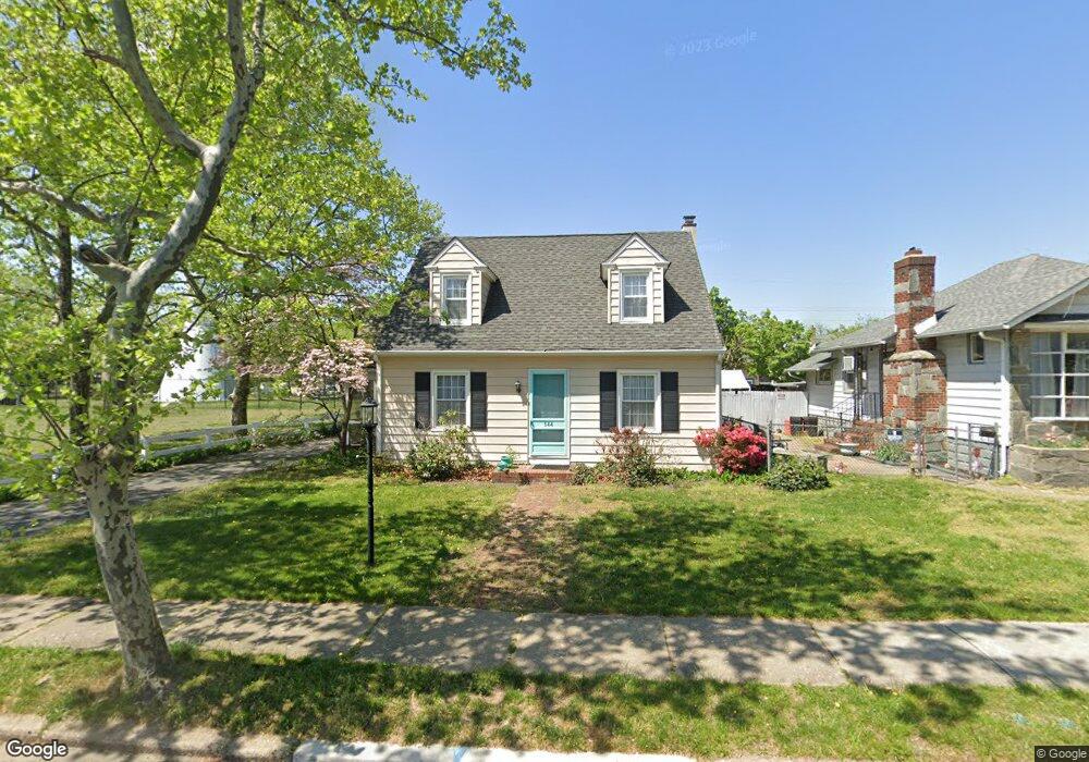
544 Nassau Ave Paulsboro, NJ 08066
Estimated Value: $232,000 - $330,000
--
Bed
--
Bath
1,268
Sq Ft
$204/Sq Ft
Est. Value
About This Home
This home is located at 544 Nassau Ave, Paulsboro, NJ 08066 and is currently estimated at $258,451, approximately $203 per square foot. 544 Nassau Ave is a home located in Gloucester County with nearby schools including Billingsport Elementary School, Loudenslager Elementary School, and Paulsboro High School.
Ownership History
Date
Name
Owned For
Owner Type
Purchase Details
Closed on
Jul 21, 2021
Sold by
Gillespie Anna F and Gillespie Anna P
Bought by
Kearney Stephen A
Current Estimated Value
Home Financials for this Owner
Home Financials are based on the most recent Mortgage that was taken out on this home.
Original Mortgage
$160,050
Outstanding Balance
$145,353
Interest Rate
2.96%
Mortgage Type
New Conventional
Estimated Equity
$113,098
Create a Home Valuation Report for This Property
The Home Valuation Report is an in-depth analysis detailing your home's value as well as a comparison with similar homes in the area
Home Values in the Area
Average Home Value in this Area
Purchase History
| Date | Buyer | Sale Price | Title Company |
|---|---|---|---|
| Kearney Stephen A | $165,000 | Atrium Executive Abstract Ll |
Source: Public Records
Mortgage History
| Date | Status | Borrower | Loan Amount |
|---|---|---|---|
| Open | Kearney Stephen A | $160,050 |
Source: Public Records
Tax History Compared to Growth
Tax History
| Year | Tax Paid | Tax Assessment Tax Assessment Total Assessment is a certain percentage of the fair market value that is determined by local assessors to be the total taxable value of land and additions on the property. | Land | Improvement |
|---|---|---|---|---|
| 2025 | $4,312 | $98,000 | $27,200 | $70,800 |
| 2024 | $4,308 | $98,000 | $27,200 | $70,800 |
| 2023 | $4,308 | $98,000 | $27,200 | $70,800 |
| 2022 | $4,230 | $98,000 | $27,200 | $70,800 |
| 2021 | $3,874 | $98,000 | $27,200 | $70,800 |
| 2020 | $4,122 | $98,000 | $27,200 | $70,800 |
| 2019 | $3,993 | $98,000 | $27,200 | $70,800 |
| 2018 | $3,764 | $98,000 | $27,200 | $70,800 |
| 2017 | $3,749 | $98,000 | $27,200 | $70,800 |
| 2016 | $3,571 | $98,000 | $27,200 | $70,800 |
| 2015 | $3,551 | $98,000 | $27,200 | $70,800 |
| 2014 | $3,631 | $107,800 | $24,400 | $83,400 |
Source: Public Records
Map
Nearby Homes
- 591 N Delaware St Unit M10
- 546 Billings Ave
- 500 Greenwich Ave
- 521 N Delaware St
- 53 Capitol St
- 423 Sheridan Ave
- 424 Sheridan Ave
- 400 Billings Ave
- 53-55 Roosevelt St
- 46 Roosevelt St
- 334 Lincoln Ave
- 300 Lincoln Ave
- 279 Lincoln Ave
- 242 Billingsport Rd
- 140 142 W Jefferson St
- 28 W Jefferson St
- 27 29 E Adams St
- 212 E Jefferson St
- 21 W Adams St
- 28 E Adams St
- 536 Nassau Ave
- 532 Nassau Ave
- 543 Lincoln Ave
- 539 Lincoln Ave
- 528 Nassau Ave
- 551 Nassau Ave
- 535 Lincoln Ave
- 537 Nassau Ave
- 529 Lincoln Ave
- 545 Nassau Ave
- 524 Nassau Ave
- 533 Nassau Ave
- 527 Lincoln Ave
- 529 Nassau Ave
- 553 Nassau Ave
- 522 Nassau Ave
- 525 Nassau Ave
- 557 Nassau Ave
- 523 Lincoln Ave
- 571 N Delaware St