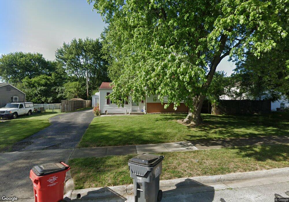
5440 Deforest Dr Columbus, OH 43232
East Columbus-White Ash NeighborhoodEstimated Value: $204,192 - $241,000
3
Beds
1
Bath
1,252
Sq Ft
$177/Sq Ft
Est. Value
About This Home
This home is located at 5440 Deforest Dr, Columbus, OH 43232 and is currently estimated at $221,798, approximately $177 per square foot. 5440 Deforest Dr is a home located in Franklin County with nearby schools including Groveport Madison High School, A+ Arts Academy, and Brice Christian Academy Elementary School.
Ownership History
Date
Name
Owned For
Owner Type
Purchase Details
Closed on
Aug 20, 2002
Sold by
Silcott Andrea J
Bought by
Patterson William W and Patterson Lori A
Current Estimated Value
Purchase Details
Closed on
Jun 12, 1998
Sold by
Moats Michael L and Moats Tamaye A
Bought by
Silcott Andrea J
Purchase Details
Closed on
Apr 3, 1989
Create a Home Valuation Report for This Property
The Home Valuation Report is an in-depth analysis detailing your home's value as well as a comparison with similar homes in the area
Home Values in the Area
Average Home Value in this Area
Purchase History
| Date | Buyer | Sale Price | Title Company |
|---|---|---|---|
| Patterson William W | $94,300 | -- | |
| Silcott Andrea J | $78,000 | Chicago Title West | |
| -- | $49,900 | -- |
Source: Public Records
Tax History
| Year | Tax Paid | Tax Assessment Tax Assessment Total Assessment is a certain percentage of the fair market value that is determined by local assessors to be the total taxable value of land and additions on the property. | Land | Improvement |
|---|---|---|---|---|
| 2025 | $2,750 | $56,810 | $16,630 | $40,180 |
| 2024 | $2,750 | $56,810 | $16,630 | $40,180 |
| 2023 | $2,732 | $56,805 | $16,625 | $40,180 |
| 2022 | $1,990 | $32,840 | $6,550 | $26,290 |
| 2021 | $2,033 | $32,840 | $6,550 | $26,290 |
| 2020 | $2,038 | $32,840 | $6,550 | $26,290 |
| 2019 | $2,039 | $28,920 | $5,710 | $23,210 |
| 2018 | $2,045 | $28,920 | $5,710 | $23,210 |
| 2017 | $2,049 | $28,920 | $5,710 | $23,210 |
| 2016 | $2,037 | $25,900 | $4,270 | $21,630 |
| 2015 | $2,039 | $25,900 | $4,270 | $21,630 |
| 2014 | $1,875 | $25,900 | $4,270 | $21,630 |
| 2013 | $907 | $28,770 | $4,725 | $24,045 |
Source: Public Records
Map
Nearby Homes
- 3246 Latonia Rd
- 3302 Everson Rd E
- 5422 Everson Rd N
- 5323 Sundale Place S
- 3333 Latonia Ct
- 3434 Latonia Rd
- 5361 Parkline Dr
- 5143 Rutledge Dr N
- 3275 Faycrest Rd
- 3455 Tremaine Rd
- 3493 Tremaine Rd
- 2998 Osgood Rd E
- 5290 Quincy Dr
- 5373 Spire Ln
- 4878 Amber Crossing Dr
- 5691 Matuka Dr
- 5408 Branchville Dr
- 5106 Harbor Blvd
- 3824 Wade Rd
- 5464 Rohden Dr
- 5428 Deforest Dr
- 3337 Everson Rd W
- 3173 Latonia Rd
- 5420 Deforest Dr
- 3179 Latonia Rd
- 3381 Everson Rd W
- 3369 Everson Rd W
- 3187 Latonia Rd
- 5441 Deforest Dr
- 5429 Deforest Dr
- 5410 Deforest Dr
- 5453 Deforest Dr
- 3191 Latonia Rd
- 5470 Deforest Dr
- 3376 Everson Rd W
- 3410 Everson Rd W
- 5459 Deforest Dr
- 3368 Everson Rd W
- 5400 Deforest Dr
- 3199 Latonia Rd
Your Personal Tour Guide
Ask me questions while you tour the home.