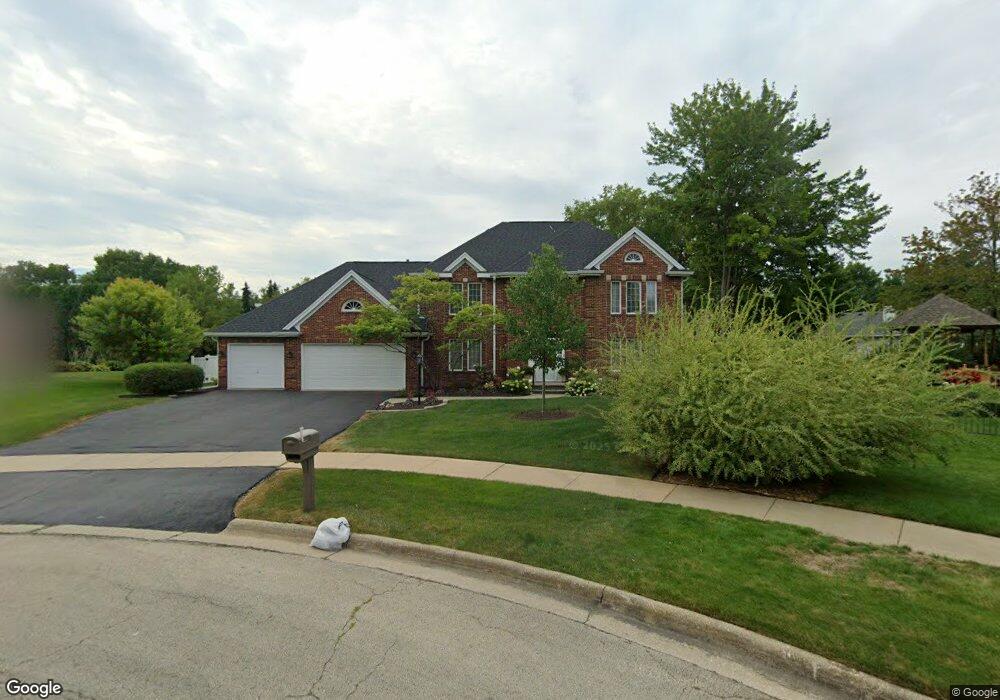
5441 Silverthorn Ct Rockford, IL 61107
Estimated Value: $390,294 - $470,000
4
Beds
4
Baths
4,152
Sq Ft
$107/Sq Ft
Est. Value
About This Home
This home is located at 5441 Silverthorn Ct, Rockford, IL 61107 and is currently estimated at $442,324, approximately $106 per square foot. 5441 Silverthorn Ct is a home located in Winnebago County with nearby schools including Brookview Elementary School, Eisenhower Middle School, and Guilford High School.
Ownership History
Date
Name
Owned For
Owner Type
Purchase Details
Closed on
Sep 5, 2024
Sold by
Marcia D Stenstrom Revocable Trust and Stenstrom Marcia D
Bought by
Daub David J and Daub Emily M
Current Estimated Value
Home Financials for this Owner
Home Financials are based on the most recent Mortgage that was taken out on this home.
Original Mortgage
$444,190
Outstanding Balance
$438,985
Interest Rate
6.25%
Mortgage Type
VA
Estimated Equity
$3,339
Create a Home Valuation Report for This Property
The Home Valuation Report is an in-depth analysis detailing your home's value as well as a comparison with similar homes in the area
Home Values in the Area
Average Home Value in this Area
Purchase History
| Date | Buyer | Sale Price | Title Company |
|---|---|---|---|
| Daub David J | $430,000 | None Listed On Document |
Source: Public Records
Mortgage History
| Date | Status | Borrower | Loan Amount |
|---|---|---|---|
| Open | Daub David J | $444,190 |
Source: Public Records
Tax History Compared to Growth
Tax History
| Year | Tax Paid | Tax Assessment Tax Assessment Total Assessment is a certain percentage of the fair market value that is determined by local assessors to be the total taxable value of land and additions on the property. | Land | Improvement |
|---|---|---|---|---|
| 2024 | $8,579 | $101,527 | $10,716 | $90,811 |
| 2023 | $8,153 | $89,522 | $9,449 | $80,073 |
| 2022 | $7,885 | $80,016 | $8,446 | $71,570 |
| 2021 | $7,644 | $73,368 | $7,744 | $65,624 |
| 2020 | $7,504 | $69,359 | $7,321 | $62,038 |
| 2019 | $7,383 | $66,107 | $6,978 | $59,129 |
| 2018 | $7,294 | $62,302 | $6,577 | $55,725 |
| 2017 | $7,214 | $59,624 | $6,294 | $53,330 |
| 2016 | $7,176 | $58,506 | $6,176 | $52,330 |
| 2015 | $7,267 | $58,506 | $6,176 | $52,330 |
| 2014 | $7,760 | $62,522 | $7,732 | $54,790 |
Source: Public Records
Map
Nearby Homes
- 2356 Silverthorn Dr
- 5075 Welsh Rd
- 2202 Churchview Unit A Dr Unit A
- 1850 N Mulford Rd
- 5382 Guilford Rd
- 4814 Spring Creek Rd
- 2699 Hickory Ave
- 6485 Shiloh
- 2180 Stornway Dr
- 1637 Coachman Dr
- 2846 Cotswold Cir
- 1718 Larkspur Dr
- 1461 Williamsburg Rd
- 6005 Boxwood Dr
- 1954 Wisteria Rd
- 6135 Lippincott Ln
- 1119 Saint Andrews Way
- 5910 Creekside Ln
- 6241 Brynwood Dr
- 1006 Oakmont Place
- 2347 Silverthorn Dr
- 5450 Roanoke Rd
- 5445 Silverthorn Ct
- 5458 Roanoke Rd
- 5430 Roanoke Rd
- 5468 Roanoke Rd
- 5448 Silverthorn Ct
- 5474 Roanoke Rd
- 2355 Silverthorn Dr
- 2116 Bordeaux Dr
- 2112 Bordeaux Dr
- 2344 Silverthorn Dr
- 2120 Bordeaux Dr
- 2348 Silverthorn Dr
- 5480 Roanoke Rd
- 5441 Roanoke Rd
- 2340 Silverthorn Dr
- 5447 Roanoke Rd
- 2352 Silverthorn Dr
- 2359 Silverthorn Dr