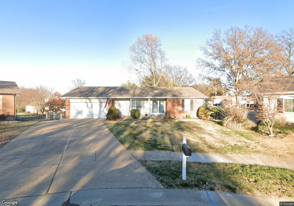
5444 Fireleaf Dr Saint Louis, MO 63129
Estimated Value: $351,000 - $393,136
4
Beds
3
Baths
1,946
Sq Ft
$191/Sq Ft
Est. Value
About This Home
This home is located at 5444 Fireleaf Dr, Saint Louis, MO 63129 and is currently estimated at $372,034, approximately $191 per square foot. 5444 Fireleaf Dr is a home located in St. Louis County with nearby schools including Oakville Elementary School, Bernard Middle School, and Oakville Senior High School.
Ownership History
Date
Name
Owned For
Owner Type
Purchase Details
Closed on
Jul 9, 2010
Sold by
Shine Charles P and Shine Deborah J
Bought by
Shine Charles P and Shine Deborah J
Current Estimated Value
Purchase Details
Closed on
Apr 28, 1998
Sold by
Bumb Michael F & Marilyn S Trs
Bought by
Shine Charles P and Shine Deborah J
Home Financials for this Owner
Home Financials are based on the most recent Mortgage that was taken out on this home.
Original Mortgage
$119,900
Outstanding Balance
$22,741
Interest Rate
7.09%
Estimated Equity
$349,293
Create a Home Valuation Report for This Property
The Home Valuation Report is an in-depth analysis detailing your home's value as well as a comparison with similar homes in the area
Home Values in the Area
Average Home Value in this Area
Purchase History
| Date | Buyer | Sale Price | Title Company |
|---|---|---|---|
| Shine Charles P | -- | None Available | |
| Shine Charles P | -- | -- |
Source: Public Records
Mortgage History
| Date | Status | Borrower | Loan Amount |
|---|---|---|---|
| Open | Shine Charles P | $119,900 |
Source: Public Records
Tax History
| Year | Tax Paid | Tax Assessment Tax Assessment Total Assessment is a certain percentage of the fair market value that is determined by local assessors to be the total taxable value of land and additions on the property. | Land | Improvement |
|---|---|---|---|---|
| 2025 | $3,834 | $61,010 | $23,160 | $37,850 |
| 2024 | $3,834 | $57,080 | $15,450 | $41,630 |
| 2023 | $3,785 | $57,080 | $15,450 | $41,630 |
| 2022 | $3,604 | $54,630 | $12,540 | $42,090 |
| 2021 | $3,488 | $54,630 | $12,540 | $42,090 |
| 2020 | $2,898 | $43,110 | $11,510 | $31,600 |
| 2019 | $2,890 | $43,110 | $11,510 | $31,600 |
| 2018 | $2,808 | $37,820 | $9,600 | $28,220 |
| 2017 | $2,804 | $37,820 | $9,600 | $28,220 |
| 2016 | $2,645 | $34,210 | $9,600 | $24,610 |
Source: Public Records
Map
Nearby Homes
- 5457 Mild Dr
- 2675 Victron Dr
- 5373 Chatfield Dr
- 3029 Yaeger Rd
- 5569 Baronridge Dr Unit 10
- 2766 Chalet Hill Dr
- 5581 Baronridge Dr Unit 5
- 5220 Autumnwinds Dr
- 2844 Blackforest Dr Unit C
- 2840 Blackforest Dr Unit B
- 5355 Casa Royale Dr
- 2781 Blackforest Dr Unit C
- 2781 Blackforest Dr Unit B
- 5048 Flintwood Dr
- 2800 Blackforest Dr Unit C
- 5766 Westphalia Ln Unit B
- 2529 Grayford Walk
- 5788 Westphalia Ln Unit 5788
- 628 Tanya Court Dr
- 4632 Ringer Rd
- 5438 Fireleaf Dr
- 5452 Fireleaf Dr
- 5433 Mild Dr
- 5427 Mild Dr
- 5458 Fireleaf Dr
- 5447 Fireleaf Dr
- 5439 Mild Dr
- 5421 Mild Dr
- 5455 Fireleaf Dr
- 2754 Yaeger Rd
- 5464 Fireleaf Dr
- 2802 Yaeger Rd
- 5459 Fireleaf Dr
- 5415 Mild Dr
- 5463 Fireleaf Dr
- 5472 Fireleaf Dr
- 5451 Mild Dr
- 5407 Mild Dr
- 5471 Fireleaf Dr
- 5480 Fireleaf Dr
Your Personal Tour Guide
Ask me questions while you tour the home.