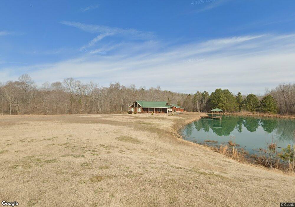
5445 Range Rd Rougemont, NC 27572
Estimated Value: $699,326 - $878,000
3
Beds
2
Baths
1,701
Sq Ft
$445/Sq Ft
Est. Value
About This Home
This home is located at 5445 Range Rd, Rougemont, NC 27572 and is currently estimated at $756,582, approximately $444 per square foot. 5445 Range Rd is a home located in Granville County with nearby schools including West Oxford Elementary School, Northern Granville Middle School, and Granville Central High School.
Ownership History
Date
Name
Owned For
Owner Type
Purchase Details
Closed on
Nov 15, 2018
Sold by
Adcock Larry N and Adcock Janet
Bought by
Piepszak Alexandra and Piepszak John
Current Estimated Value
Home Financials for this Owner
Home Financials are based on the most recent Mortgage that was taken out on this home.
Original Mortgage
$360,000
Outstanding Balance
$315,900
Interest Rate
4.7%
Mortgage Type
New Conventional
Estimated Equity
$440,682
Purchase Details
Closed on
Aug 12, 2009
Sold by
Morris Roger Dewey and Morris Gina
Bought by
Adcock Larry N and Adcock Janet
Create a Home Valuation Report for This Property
The Home Valuation Report is an in-depth analysis detailing your home's value as well as a comparison with similar homes in the area
Purchase History
| Date | Buyer | Sale Price | Title Company |
|---|---|---|---|
| Piepszak Alexandra | $435,000 | None Available | |
| Adcock Larry N | $35,000 | -- |
Source: Public Records
Mortgage History
| Date | Status | Borrower | Loan Amount |
|---|---|---|---|
| Open | Piepszak Alexandra | $360,000 |
Source: Public Records
Tax History
| Year | Tax Paid | Tax Assessment Tax Assessment Total Assessment is a certain percentage of the fair market value that is determined by local assessors to be the total taxable value of land and additions on the property. | Land | Improvement |
|---|---|---|---|---|
| 2025 | $4,309 | $612,964 | $105,117 | $507,847 |
| 2024 | $4,309 | $612,964 | $105,117 | $507,847 |
| 2023 | $2,177 | $228,350 | $46,091 | $182,259 |
| 2022 | $2,156 | $228,350 | $46,091 | $182,259 |
| 2021 | $2,014 | $228,350 | $46,091 | $182,259 |
| 2020 | $2,014 | $228,350 | $46,091 | $182,259 |
| 2019 | $2,014 | $228,350 | $46,091 | $182,259 |
| 2018 | $2,014 | $228,350 | $46,091 | $182,259 |
| 2016 | $1,902 | $200,363 | $44,827 | $155,536 |
| 2015 | $1,801 | $200,363 | $44,827 | $155,536 |
| 2014 | $1,786 | $200,363 | $44,827 | $155,536 |
| 2013 | -- | $200,363 | $44,827 | $155,536 |
Source: Public Records
Map
Nearby Homes
- Lot 2 Collie Jones Rd
- Lot 4 Collie Jones Rd
- Lot 3 Collie Jones Rd
- 000 Allen Creek Rd
- Lot 6 & 7 Hunters Cir
- 00 Mann Oakley Rd
- 0 Owens Daye Rd
- 2081 Peed Rd
- 5586 Shelton Creek Rd
- 125 Ninovan Place
- 5590 Shelton Creek Rd
- 4459 Poppy Mallow Ln
- Lot 11 Poppy Mallow Ln
- 0 Old Roxboro Rd Unit 10027603
- 460 Medford Oakley Rd
- Lot 17 Crown Oaks Dr
- 5606 Oakley Hill
- 18.2 Acres Range Rd
- 6182 Bob Daniel Rd
- 6190 Bob Daniel Rd
- 532 George Sherman Rd
- 5413 Range Rd
- 548 George Sherman Rd
- 5453 Range Rd
- 534 George Sherman Rd
- 5454 Range Rd
- 530 George Sherman Rd
- 533 George Sherman Rd
- 5400 Range Rd
- 561 George Sherman Rd
- 5515 Marys Way
- 551 George Sherman Rd
- 5460 Range Rd
- 5367 Range Rd
- 5516 Marys Way
- 5519 Marys Way
- 573 George Sherman Rd
- 500 George Sherman Rd
- 0 Marys Way Unit 1806228
- 0 Marys Way Unit 1664718
Your Personal Tour Guide
Ask me questions while you tour the home.