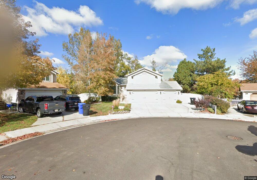
5446 S Crosspointe Cir Salt Lake City, UT 84123
Estimated Value: $544,000 - $579,644
3
Beds
3
Baths
2,316
Sq Ft
$240/Sq Ft
Est. Value
About This Home
This home is located at 5446 S Crosspointe Cir, Salt Lake City, UT 84123 and is currently estimated at $556,161, approximately $240 per square foot. 5446 S Crosspointe Cir is a home located in Salt Lake County with nearby schools including Plymouth Elementary School, Eisenhower Jr High School, and Taylorsville High School.
Ownership History
Date
Name
Owned For
Owner Type
Purchase Details
Closed on
Oct 31, 1996
Sold by
Plant Craig E and Plant Valerie M
Bought by
Rippy Dennis R and Rippy Judith I
Current Estimated Value
Home Financials for this Owner
Home Financials are based on the most recent Mortgage that was taken out on this home.
Original Mortgage
$139,200
Outstanding Balance
$13,743
Interest Rate
8.11%
Mortgage Type
Purchase Money Mortgage
Estimated Equity
$542,418
Purchase Details
Closed on
May 20, 1994
Sold by
Davenport Edward Jay and Victoria Davenport M
Bought by
Plant Craig E and Plant Valerie M
Home Financials for this Owner
Home Financials are based on the most recent Mortgage that was taken out on this home.
Original Mortgage
$119,000
Interest Rate
8.3%
Mortgage Type
Purchase Money Mortgage
Create a Home Valuation Report for This Property
The Home Valuation Report is an in-depth analysis detailing your home's value as well as a comparison with similar homes in the area
Home Values in the Area
Average Home Value in this Area
Purchase History
| Date | Buyer | Sale Price | Title Company |
|---|---|---|---|
| Rippy Dennis R | -- | -- | |
| Plant Craig E | -- | -- |
Source: Public Records
Mortgage History
| Date | Status | Borrower | Loan Amount |
|---|---|---|---|
| Open | Rippy Dennis R | $139,200 | |
| Previous Owner | Plant Craig E | $119,000 |
Source: Public Records
Tax History Compared to Growth
Tax History
| Year | Tax Paid | Tax Assessment Tax Assessment Total Assessment is a certain percentage of the fair market value that is determined by local assessors to be the total taxable value of land and additions on the property. | Land | Improvement |
|---|---|---|---|---|
| 2025 | $234 | $537,000 | $140,200 | $396,800 |
| 2024 | $234 | $517,500 | $135,800 | $381,700 |
| 2023 | $372 | $471,100 | $126,900 | $344,200 |
| 2022 | $372 | $479,500 | $124,400 | $355,100 |
| 2021 | $156 | $365,900 | $95,700 | $270,200 |
| 2020 | $2,436 | $325,800 | $88,000 | $237,800 |
| 2019 | $94 | $321,400 | $88,000 | $233,400 |
| 2018 | $253 | $298,200 | $85,200 | $213,000 |
| 2017 | $122 | $280,500 | $85,200 | $195,300 |
| 2016 | $2,083 | $264,300 | $85,200 | $179,100 |
| 2015 | $2,083 | $257,500 | $86,800 | $170,700 |
| 2014 | $1,999 | $242,600 | $82,800 | $159,800 |
Source: Public Records
Map
Nearby Homes
- 1443 W Spinnaker Row Unit 96
- 5449 S Coastal Ct
- 5435 S Break Water Dr
- 1380 W Ocean Ct
- 1334 Portside Way Unit 165
- 1370 W Telegraph Hill Dr
- 1401 Beacon Hill Dr Unit 118
- 1381 Beacon Hill Dr
- 1273 W Brister Dr
- 5920 S 1300 W
- 1886 W Champagne Ave
- 5552 Hew Wood Dr
- 2001 W 5540 S
- 2016 W Hew Wood Ct
- 5020 S 1250 W
- 1475 W 4950 S
- 903 W Bullion St
- 913 W Bullion St Unit 10
- Hirst 2 Plan at The Gallery at Bullion - Townhomes
- Caro 2 Plan at The Gallery at Bullion - Townhomes
- 5446 Crosspointe Cir
- 5452 Crosspointe Cir
- 5452 S Crosspointe Cir
- 5447 Crosspointe Cir
- 5447 S Crosspointe Cir
- 5441 S 1500 W
- 5449 S 1500 W
- 5460 Crosspointe Cir
- 1465 W Harbor Pointe Dr Unit 43
- 1465 W Harbor Pointe Dr Unit 43
- 1465 W Harbor Pointe Dr
- 5451 Crosspointe Cir
- 5453 S Spinnaker Row
- 5453 Spinnaker Row
- 5459 S Spinnaker Row
- 5459 Spinnaker Row
- 5459 S 1500 W
- 5464 S Lighthouse Rd
- 5422 Lighthouse Rd Unit 66
- 1459 W Harbor Pointe Dr