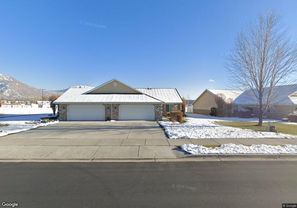
545 S 1040 E American Fork, UT 84003
Estimated Value: $431,000 - $462,000
2
Beds
2
Baths
1,430
Sq Ft
$310/Sq Ft
Est. Value
About This Home
This home is located at 545 S 1040 E, American Fork, UT 84003 and is currently estimated at $443,326, approximately $310 per square foot. 545 S 1040 E is a home located in Utah County with nearby schools including Barratt Elementary School, American Fork Junior High School, and American Fork High School.
Ownership History
Date
Name
Owned For
Owner Type
Purchase Details
Closed on
Oct 5, 2023
Sold by
Pugmire Family Trust
Bought by
Patricia A Lawyer Revocable Trust and Webster
Current Estimated Value
Purchase Details
Closed on
Aug 2, 2021
Sold by
Stoy Marycarolyn
Bought by
Pugmire David M and Pugmire Anne M
Purchase Details
Closed on
Oct 25, 2013
Sold by
Stoy Marycarolyn
Bought by
Stoy Marycarolyn and Pugmire David M
Purchase Details
Closed on
Jul 19, 2007
Sold by
Mira Condominiums Development Llc
Bought by
Stoy Marycarolyn and Pugmire David M
Create a Home Valuation Report for This Property
The Home Valuation Report is an in-depth analysis detailing your home's value as well as a comparison with similar homes in the area
Home Values in the Area
Average Home Value in this Area
Purchase History
| Date | Buyer | Sale Price | Title Company |
|---|---|---|---|
| Patricia A Lawyer Revocable Trust | -- | Inwest Title | |
| Pugmire David M | -- | None Available | |
| Stoy Marycarolyn | -- | First American Title Ins | |
| Stoy Marycarolyn | -- | First American Title Co Llc | |
| Stoy Marycarolyn | -- | Signature Title Insurance A |
Source: Public Records
Tax History
| Year | Tax Paid | Tax Assessment Tax Assessment Total Assessment is a certain percentage of the fair market value that is determined by local assessors to be the total taxable value of land and additions on the property. | Land | Improvement |
|---|---|---|---|---|
| 2025 | $1,969 | $222,750 | -- | -- |
| 2024 | $1,969 | $218,735 | $0 | $0 |
| 2023 | $1,788 | $210,595 | $0 | $0 |
| 2022 | $1,915 | $222,640 | $0 | $0 |
| 2021 | $1,715 | $311,400 | $80,000 | $231,400 |
| 2020 | $1,668 | $293,800 | $80,000 | $213,800 |
| 2019 | $1,496 | $272,500 | $80,000 | $192,500 |
| 2018 | $1,551 | $270,100 | $80,000 | $190,100 |
| 2017 | $1,551 | $145,805 | $0 | $0 |
| 2016 | $1,456 | $127,160 | $0 | $0 |
| 2015 | $1,460 | $121,000 | $0 | $0 |
Source: Public Records
Map
Nearby Homes
- 517 S 1040 E
- 502 S 1040 E Unit 252
- 502 S 1040 E Unit 150
- 502 S 1040 E Unit 243
- 603 S 1040 E
- 477 S 850 E
- 29 S 2000 W
- 1058 E State Rd
- 28 S 1800 W
- 293 N 1630 W
- 782 E 500 S
- 250 N 1630 W
- 276 N 1630 W
- 1748 W 120 S Unit 58
- 18 S 1630 W
- 1593 W 220 N
- 765 E 550 S
- 295 N 1580 W
- 1755 W 120 S Unit 56
- 118 S 1700 W Unit 11
- 545 S 1040 E Unit 387
- 543 S 1040 E
- 543 S 1040 E Unit 19
- 547 S 1040 E
- 549 S 1040 E
- 531 S 1040 E
- 531 S 1040 E Unit 391
- 551 S 1040 E Unit 24
- 520 1040 E Unit D138
- 529 S 1040 E
- 553 S 1040 E Unit 25
- 532 S 1040 E
- 565 S 1040 E Unit 26
- 565 S 1040 E
- 515 S 1040 E
- 544 S 1040 E
- 544 S 1040 E Unit 61
- 567 S 1040 E Unit 27
- 534 S 1040 E Unit 63
- 534 S 1040 E Unit 62
Your Personal Tour Guide
Ask me questions while you tour the home.