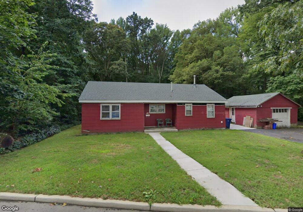
545 Station Rd Roebling, NJ 08554
Estimated Value: $221,960 - $307,000
--
Bed
--
Bath
1,052
Sq Ft
$253/Sq Ft
Est. Value
About This Home
This home is located at 545 Station Rd, Roebling, NJ 08554 and is currently estimated at $265,740, approximately $252 per square foot. 545 Station Rd is a home located in Burlington County with nearby schools including Riverfront Middle School, Number 5, Roebling Elementary School, and Florence Twp Mem High School.
Ownership History
Date
Name
Owned For
Owner Type
Purchase Details
Closed on
Apr 30, 2001
Sold by
Cumberland Beth
Bought by
Zuber Bryan
Current Estimated Value
Home Financials for this Owner
Home Financials are based on the most recent Mortgage that was taken out on this home.
Original Mortgage
$80,400
Interest Rate
7.09%
Mortgage Type
Stand Alone First
Purchase Details
Closed on
Dec 29, 1997
Sold by
Reeves Frances L and Reeves Roy M
Bought by
Cumberland Beth
Create a Home Valuation Report for This Property
The Home Valuation Report is an in-depth analysis detailing your home's value as well as a comparison with similar homes in the area
Home Values in the Area
Average Home Value in this Area
Purchase History
| Date | Buyer | Sale Price | Title Company |
|---|---|---|---|
| Zuber Bryan | $84,670 | Weichert Title Agency | |
| -- | $84,700 | -- | |
| Cumberland Beth | $68,000 | T A Title Insurance Company |
Source: Public Records
Mortgage History
| Date | Status | Borrower | Loan Amount |
|---|---|---|---|
| Previous Owner | -- | $80,400 |
Source: Public Records
Tax History Compared to Growth
Tax History
| Year | Tax Paid | Tax Assessment Tax Assessment Total Assessment is a certain percentage of the fair market value that is determined by local assessors to be the total taxable value of land and additions on the property. | Land | Improvement |
|---|---|---|---|---|
| 2025 | $4,175 | $149,800 | $77,700 | $72,100 |
| 2024 | $3,997 | $149,800 | $77,700 | $72,100 |
| 2023 | $3,997 | $149,800 | $77,700 | $72,100 |
| 2022 | $3,911 | $149,800 | $77,700 | $72,100 |
| 2021 | $3,673 | $149,800 | $77,700 | $72,100 |
| 2020 | $3,862 | $149,800 | $77,700 | $72,100 |
| 2019 | $3,827 | $149,800 | $77,700 | $72,100 |
| 2018 | $3,794 | $149,800 | $77,700 | $72,100 |
| 2017 | $3,748 | $149,800 | $77,700 | $72,100 |
| 2016 | $3,676 | $149,800 | $77,700 | $72,100 |
| 2015 | $3,601 | $149,800 | $77,700 | $72,100 |
| 2014 | $3,501 | $149,800 | $77,700 | $72,100 |
Source: Public Records
Map
Nearby Homes
- 0 Station Rd
- 2075 Route 130 N
- 184 Birch Hollow Dr Unit 58
- 1291 Highview Ave
- 10 Applegate Dr
- 891 E 3rd St
- 809 Olive St
- 60 River Bank Dr
- 28 Magnolia Ct Unit 10
- 22 River Bank Dr
- 32 River Bank Dr
- 34 River Bank Dr
- 89 River Bank Dr
- 617 E 6th St
- 149 7th Ave
- 101 Main St
- 227 5th Ave
- 1448 Hornberger Ave
- 65 Main St
- 125 4th Ave
- 557 Delaware Ave
- 604 Station Rd
- 555 Delaware Ave
- 583 Delaware Ave
- 567 Delaware Ave
- 624 Station Rd
- 605 Delaware Ave
- 595 Delaware Ave
- 501 Delaware Ave Unit 1
- 501 Delaware Ave
- 644 Station Rd
- 625 Delaware Ave
- 625 Delaware Ave Unit A
- 654 Station Rd
- 639 Delaware Ave
- 518 Delaware Ave
- 653 Delaware Ave
- 566 Delaware Ave
- 556 Delaware Ave
- 608 Delaware Ave