Estimated Value: $290,000 - $410,000
4
Beds
3
Baths
1,680
Sq Ft
$200/Sq Ft
Est. Value
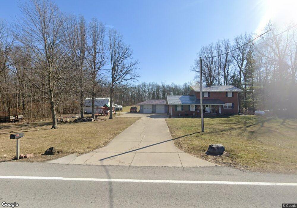
About This Home
This home is located at 5456 State Route 701, Ada, OH 45810 and is currently estimated at $336,185, approximately $200 per square foot. 5456 State Route 701 is a home located in Hardin County with nearby schools including Upper Scioto Valley Elementary School, Upper Scioto Valley Middle School, and Upper Scioto Valley High School.
Ownership History
Date
Name
Owned For
Owner Type
Purchase Details
Closed on
Apr 21, 2014
Sold by
Burd Shane W and Burd Jacinta A
Bought by
Shirk William and Shirk Amy
Current Estimated Value
Home Financials for this Owner
Home Financials are based on the most recent Mortgage that was taken out on this home.
Original Mortgage
$134,300
Outstanding Balance
$102,362
Interest Rate
4.41%
Mortgage Type
New Conventional
Estimated Equity
$233,823
Purchase Details
Closed on
Feb 3, 2006
Sold by
Holtz Lee B and Savino Lee B
Bought by
Burd Shane W and Burd Jacinta A
Home Financials for this Owner
Home Financials are based on the most recent Mortgage that was taken out on this home.
Original Mortgage
$139,000
Interest Rate
6.34%
Mortgage Type
Future Advance Clause Open End Mortgage
Purchase Details
Closed on
Jul 23, 1987
Create a Home Valuation Report for This Property
The Home Valuation Report is an in-depth analysis detailing your home's value as well as a comparison with similar homes in the area
Home Values in the Area
Average Home Value in this Area
Purchase History
| Date | Buyer | Sale Price | Title Company |
|---|---|---|---|
| Shirk William | $158,000 | None Available | |
| Burd Shane W | $139,000 | Golden Key Title Agency | |
| -- | $65,000 | -- |
Source: Public Records
Mortgage History
| Date | Status | Borrower | Loan Amount |
|---|---|---|---|
| Open | Shirk William | $134,300 | |
| Previous Owner | Burd Shane W | $139,000 |
Source: Public Records
Tax History Compared to Growth
Tax History
| Year | Tax Paid | Tax Assessment Tax Assessment Total Assessment is a certain percentage of the fair market value that is determined by local assessors to be the total taxable value of land and additions on the property. | Land | Improvement |
|---|---|---|---|---|
| 2024 | $3,070 | $90,240 | $8,050 | $82,190 |
| 2023 | $3,070 | $90,240 | $8,050 | $82,190 |
| 2022 | $2,733 | $71,340 | $5,460 | $65,880 |
| 2021 | $2,895 | $71,340 | $5,460 | $65,880 |
| 2020 | $2,932 | $71,340 | $5,460 | $65,880 |
| 2019 | $2,189 | $57,820 | $5,250 | $52,570 |
| 2018 | $2,203 | $57,820 | $5,250 | $52,570 |
| 2017 | $1,884 | $57,820 | $5,250 | $52,570 |
| 2016 | $1,609 | $47,220 | $4,730 | $42,490 |
| 2015 | $1,573 | $47,220 | $4,730 | $42,490 |
| 2014 | $1,608 | $47,220 | $4,730 | $42,490 |
| 2013 | $1,872 | $51,190 | $4,730 | $46,460 |
Source: Public Records
Map
Nearby Homes
- 3931 County Road 80
- 2864 Ohio 309
- 501 Elm St
- 710 S Main St
- 314 E University Ave
- 308-310 S Simon St
- 301 S Main St
- 212 N Simon St
- 211 S Main St
- 442 Edwards St
- 444 Edwards St Unit A, B
- 444 Edwards St Unit 2
- 211 W Buckeye Ave Unit 211 1/2
- 210 N Gilbert St
- 900 N Front St
- 203 Belmont St
- 128 W North Ave
- 629 N Main St
- 4071 Township Road 35
- 6782 County Road 15
- 5456 Ohio 701
- 5456 St Route
- 5456 Sr
- 5834 State Route 701
- 5432 State Route 701
- 5416 State Route 701
- 5388 State Route 701
- 5388 Sr
- 5307 State Route 701
- 5710 State Route 701
- 5710 State Route 701
- 5710 St Route
- 5786 State Route 701
- 5786 St Route
- 6200 County Road 65
- 6097 County Rd
- 6097 Cr
- 6097 County Road 75