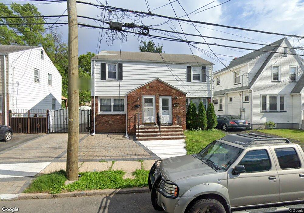
546 Buchanan St Hillside, NJ 07205
Estimated Value: $312,246 - $441,000
Studio
--
Bath
924
Sq Ft
$403/Sq Ft
Est. Value
About This Home
This home is located at 546 Buchanan St, Hillside, NJ 07205 and is currently estimated at $372,062, approximately $402 per square foot. 546 Buchanan St is a home located in Union County with nearby schools including Abram P. Morris-Saybrook Elementary School, Calvin Coolidge Elementary School, and Hurden Looker School.
Ownership History
Date
Name
Owned For
Owner Type
Purchase Details
Closed on
Feb 13, 2004
Sold by
Jordan Cheryl
Bought by
Ansah Victor
Current Estimated Value
Home Financials for this Owner
Home Financials are based on the most recent Mortgage that was taken out on this home.
Original Mortgage
$128,250
Interest Rate
5.39%
Purchase Details
Closed on
Dec 15, 1994
Sold by
Froehlich Ralph
Bought by
Apx Mtg Services Inc
Create a Home Valuation Report for This Property
The Home Valuation Report is an in-depth analysis detailing your home's value as well as a comparison with similar homes in the area
Home Values in the Area
Average Home Value in this Area
Purchase History
| Date | Buyer | Sale Price | Title Company |
|---|---|---|---|
| Ansah Victor | $135,000 | -- | |
| Apx Mtg Services Inc | -- | -- |
Source: Public Records
Mortgage History
| Date | Status | Borrower | Loan Amount |
|---|---|---|---|
| Previous Owner | Ansah Victor | $128,250 |
Source: Public Records
Tax History
| Year | Tax Paid | Tax Assessment Tax Assessment Total Assessment is a certain percentage of the fair market value that is determined by local assessors to be the total taxable value of land and additions on the property. | Land | Improvement |
|---|---|---|---|---|
| 2025 | $5,397 | $65,400 | $27,000 | $38,400 |
| 2024 | $5,241 | $65,400 | $27,000 | $38,400 |
| 2023 | $5,241 | $65,400 | $27,000 | $38,400 |
| 2022 | $5,192 | $65,400 | $27,000 | $38,400 |
| 2021 | $5,158 | $65,400 | $27,000 | $38,400 |
| 2020 | $5,128 | $65,400 | $27,000 | $38,400 |
| 2019 | $5,029 | $65,400 | $27,000 | $38,400 |
| 2018 | $4,978 | $65,400 | $27,000 | $38,400 |
| 2017 | $4,948 | $65,400 | $27,000 | $38,400 |
| 2016 | $4,942 | $65,400 | $27,000 | $38,400 |
| 2015 | $4,898 | $65,400 | $27,000 | $38,400 |
| 2014 | $4,821 | $65,400 | $27,000 | $38,400 |
Source: Public Records
Map
Nearby Homes
- 564 Chapman St
- 575 Purce St
- 552 Paul St Unit 8
- 537 Us Highway 22
- 525 Us Highway 22
- 35 Eastern Pkwy
- 359 Harvard Ave
- 1611 N Sunset Place
- 1393 Cornell Place
- 339 Hillside Ave
- 339 Hillside Ave Unit 2
- 120 Parkside Dr
- 260 Millard Ave
- 1426 Franklin St
- 28 Hoffman Place
- 222 Boston Ave
- 539 Union Ave Unit 4
- 7 Wolf Place
- 1442 Highland Ave
- 58 Naden Ave
- 544 Buchanan St
- 548 Buchanan St
- 540 Buchanan St
- 550 Buchanan St
- 538 Buchanan St
- 552 Buchanan St
- 547 Tillman St
- 536 Buchanan St
- 543 Tillman St
- 551 Tillman St
- 541 Tillman St
- 556 Buchanan St
- 534 Buchanan St
- 553 Tillman St
- 539 Tillman St
- 545 Buchanan St
- 547 Buchanan St
- 543 Buchanan St
- 558 Buchanan St
- 551 Buchanan St
Your Personal Tour Guide
Ask me questions while you tour the home.