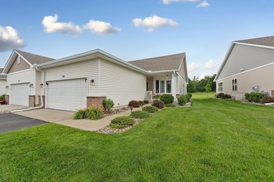
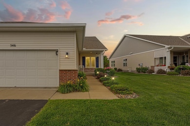
546 Cannon Way Dundas, MN 55019
Estimated payment $2,647/month
Highlights
- Deck
- Stainless Steel Appliances
- Brick Veneer
- Bridgewater Elementary School Rated A
- 2 Car Attached Garage
- Walk-In Closet
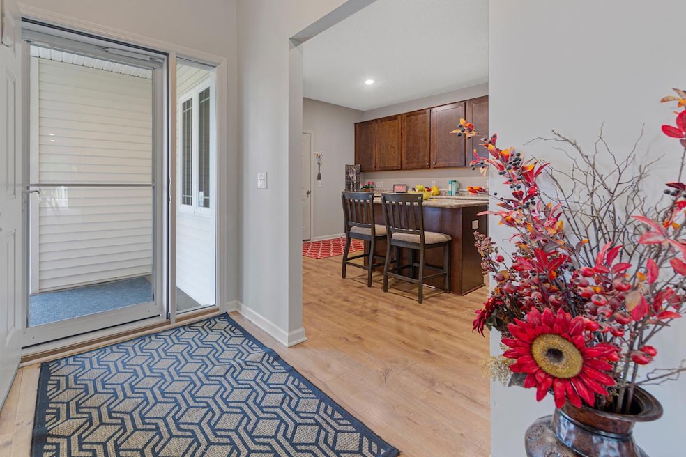
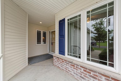
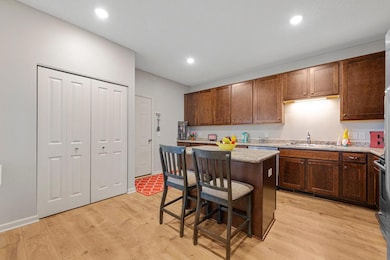
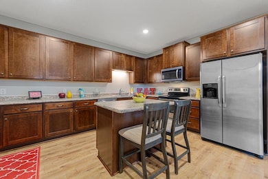
About This Home
LOW HOA!!! Welcome to your future home, a beautifully maintained 1-level end-unit townhome offering comfort, convenience, and an abundance of natural brightness throughout. Step inside to discover a freshly painted interior and brand new carpeting, creating a warm and inviting atmosphere. This radiant home features all living facilities on one level including Primary bedroom suite and guest room. The finished basement provides additional living space, perfect for a family room with guest bedroom, attached full bath, and walk-in closet. Enjoy the privacy and airy ambiance of an end unit, along with the care and upkeep evident in every detail. A wonderful opportunity to turn the key and live your best life!
Townhouse Details
Home Type
- Townhome
Est. Annual Taxes
- $5,286
Year Built
- Built in 2016
Lot Details
- 4,356 Sq Ft Lot
- Lot Dimensions are 100x45
HOA Fees
- $230 Monthly HOA Fees
Parking
- 2 Car Attached Garage
- Garage Door Opener
- Guest Parking
Home Design
- Brick Veneer
- Vinyl Siding
Interior Spaces
- 1-Story Property
- Gas Fireplace
- Entrance Foyer
- Family Room
- Living Room
- Dining Room
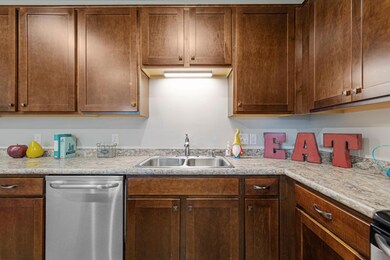
Kitchen
- Range
- Microwave
- Dishwasher
- Stainless Steel Appliances
Bedrooms and Bathrooms
- 3 Bedrooms
- En-Suite Bathroom
- Walk-In Closet
Laundry
- Dryer
- Washer
Finished Basement
- Basement Fills Entire Space Under The House
- Basement Window Egress
Utilities
- Forced Air Heating and Cooling System
- Underground Utilities
- Gas Water Heater
- Water Softener is Owned
Additional Features
- Air Exchanger
- Deck
Community Details
- Association fees include hazard insurance, lawn care, ground maintenance, professional mgmt, snow removal
- Trekk Association, Phone Number (507) 334-3499
- Bridgewater Heights Subdivision
Listing and Financial Details
- Assessor Parcel Number 1713226070
Map
Home Values in the Area
Average Home Value in this Area
Tax History
| Year | Tax Paid | Tax Assessment Tax Assessment Total Assessment is a certain percentage of the fair market value that is determined by local assessors to be the total taxable value of land and additions on the property. | Land | Improvement |
|---|---|---|---|---|
| 2025 | $5,326 | $370,800 | $88,800 | $282,000 |
| 2024 | $5,326 | $343,300 | $88,800 | $254,500 |
| 2023 | $4,696 | $343,300 | $88,800 | $254,500 |
| 2022 | $4,102 | $319,200 | $92,800 | $226,400 |
| 2021 | $4,020 | $264,100 | $60,300 | $203,800 |
| 2020 | $3,848 | $252,200 | $60,300 | $191,900 |
| 2019 | $3,404 | $242,700 | $60,300 | $182,400 |
| 2018 | $1,476 | $212,100 | $59,400 | $152,700 |
| 2017 | $528 | $103,900 | $59,400 | $44,500 |
| 2016 | $526 | $23,800 | $23,800 | $0 |
| 2015 | $512 | $23,800 | $23,800 | $0 |
| 2014 | -- | $23,800 | $23,800 | $0 |
Property History
| Date | Event | Price | List to Sale | Price per Sq Ft |
|---|---|---|---|---|
| 10/16/2025 10/16/25 | Price Changed | $375,000 | -3.8% | $154 / Sq Ft |
| 10/09/2025 10/09/25 | For Sale | $390,000 | -- | $160 / Sq Ft |
Purchase History
| Date | Type | Sale Price | Title Company |
|---|---|---|---|
| Quit Claim Deed | $500 | None Listed On Document | |
| Quit Claim Deed | $500 | None Listed On Document | |
| Interfamily Deed Transfer | -- | None Available | |
| Warranty Deed | $218,660 | Dhi Title Of Minnesota Inc | |
| Warranty Deed | $8,196,282 | -- |
Mortgage History
| Date | Status | Loan Amount | Loan Type |
|---|---|---|---|
| Previous Owner | $174,928 | New Conventional |
Source: NorthstarMLS
MLS Number: 6800948
APN: 17.13.2.26.070
Disclaimer: Certain information contained herein is derived from information provided by parties other than Homes.com. All information provided is deemed reliable, but is not guaranteed to be accurate and should be independently verified.
![]() Based on information submitted to the MLS GRID. All data is obtained from various sources and may not have been verified by broker or MLS GRID. Supplied Open House Information is subject to change without notice. All information should be independently reviewed and verified for accuracy. Properties may or may not be listed by the office/agent presenting the information. Some IDX listings have been excluded from this website.
Based on information submitted to the MLS GRID. All data is obtained from various sources and may not have been verified by broker or MLS GRID. Supplied Open House Information is subject to change without notice. All information should be independently reviewed and verified for accuracy. Properties may or may not be listed by the office/agent presenting the information. Some IDX listings have been excluded from this website.
The Digital Millennium Copyright Act of 1998, 17 U.S.C. § 512 (the “DMCA”) provides recourse for copyright owners who believe that material appearing on the Internet infringes their rights under U.S. copyright law. If you believe in good faith that any content or material made available in connection with our website or services infringes your copyright, you (or your agent) may send us a notice requesting that the content or material be removed, or access to it blocked.
Notices must be sent in writing by email to DMCAnotice@MLSGrid.com.
The DMCA requires that your notice of alleged copyright infringement include the following information:
(1) description of the copyrighted work that is the subject of claimed infringement;
(2) description of the alleged infringing content and information sufficient to permit us to locate the content;
(3) contact information for you, including your address, telephone number and email address;
(4) a statement by you that you have a good faith belief that the content in the manner complained of is not authorized by the copyright owner, or its agent, or by the operation of any law;
(5) a statement by you, signed under penalty of perjury, that the information in the notification is accurate and that you have the authority to enforce the copyrights that are claimed to be infringed; and
(6) a physical or electronic signature of the copyright owner or a person authorized to act on the copyright owner’s behalf. Failure to include all of the above information may result in the delay of the processing of your complaint.
- 555 Cannon Way
- 513 Cannon Way
- 2804 Oak Lawn Dr
- 2708 Oak Lawn Dr
- 1418 Bluff St
- 2826 Brockman Ct
- 1258 Bluff St
- 1355 Bridgewater Pkwy
- 115 115th St E
- 2620 Oak Lawn Dr
- Outlot Honeylocust Dr
- 2004 Lincoln St S
- 709 Carter Dr
- 2116 Park Pointe Dr
- 2220 Greenfield Dr E
- 900 Cannon Rd
- 17 Jefferson Dr
- 1900 Jefferson Rd
- xxx Weaver Rd
- 1741 Roosevelt Dr
- 2411-2431 Jefferson Rd
- 1370 Heritage Dr
- 1400 Heritage Dr
- 2005 Jefferson Rd
- 1900-1960 Roosevelt Dr
- 80 West Ave W
- 500 Woodley St W
- 116 5th St E
- 801 Kraewood Dr
- 710-740 N Highway 3
- 601 1st Ave NE
- 616 2nd St NE
- 200 Heritage Place
- 123 2nd St NW
- 128 2nd Ave NW Unit 2
- 110 Riverchase Ct
- 1402 Division St W Unit 1
- 1402 Division St W Unit 7
- 1218 Aldrich Way
- 851 Faribault Rd
