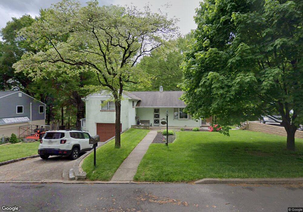
546 Hillside Ave Langhorne, PA 19047
Estimated Value: $363,573 - $454,000
3
Beds
2
Baths
1,270
Sq Ft
$322/Sq Ft
Est. Value
About This Home
This home is located at 546 Hillside Ave, Langhorne, PA 19047 and is currently estimated at $409,143, approximately $322 per square foot. 546 Hillside Ave is a home located in Bucks County with nearby schools including Hoover Elementary School, Maple Point Middle School, and Neshaminy High School.
Ownership History
Date
Name
Owned For
Owner Type
Purchase Details
Closed on
Mar 30, 2001
Sold by
Askey Raymond and Askey Deborah
Bought by
Askey Raymond K
Current Estimated Value
Home Financials for this Owner
Home Financials are based on the most recent Mortgage that was taken out on this home.
Original Mortgage
$128,000
Outstanding Balance
$47,010
Interest Rate
6.97%
Estimated Equity
$362,133
Purchase Details
Closed on
Jan 4, 1993
Bought by
Askey Raymond and Askey Deborah
Create a Home Valuation Report for This Property
The Home Valuation Report is an in-depth analysis detailing your home's value as well as a comparison with similar homes in the area
Home Values in the Area
Average Home Value in this Area
Purchase History
| Date | Buyer | Sale Price | Title Company |
|---|---|---|---|
| Askey Raymond K | -- | First American Title Ins Co | |
| Askey Raymond | $90,000 | -- |
Source: Public Records
Mortgage History
| Date | Status | Borrower | Loan Amount |
|---|---|---|---|
| Open | Askey Raymond K | $128,000 |
Source: Public Records
Tax History Compared to Growth
Tax History
| Year | Tax Paid | Tax Assessment Tax Assessment Total Assessment is a certain percentage of the fair market value that is determined by local assessors to be the total taxable value of land and additions on the property. | Land | Improvement |
|---|---|---|---|---|
| 2025 | $4,006 | $18,400 | $4,320 | $14,080 |
| 2024 | $4,006 | $18,400 | $4,320 | $14,080 |
| 2023 | $3,942 | $18,400 | $4,320 | $14,080 |
| 2022 | $3,839 | $18,400 | $4,320 | $14,080 |
| 2021 | $3,839 | $18,400 | $4,320 | $14,080 |
| 2020 | $3,793 | $18,400 | $4,320 | $14,080 |
| 2019 | $3,708 | $18,400 | $4,320 | $14,080 |
| 2018 | $3,640 | $18,400 | $4,320 | $14,080 |
| 2017 | $3,547 | $18,400 | $4,320 | $14,080 |
| 2016 | $3,547 | $18,400 | $4,320 | $14,080 |
| 2015 | $3,736 | $18,400 | $4,320 | $14,080 |
| 2014 | $3,736 | $18,400 | $4,320 | $14,080 |
Source: Public Records
Map
Nearby Homes
- 6369 Powder Horn Ct
- 409 Fairview Ave
- 3225 Ethan Allen Ct
- 547 Hulmeville Ave
- 3351 Carroll Ct Unit S
- 801 E Parker St Unit B2
- 6257 Nathan Hale Ct
- 790 E Parker St Unit A1
- 6561 Neshaminy Valley Dr
- 2548 Nashua Rd
- 3325 Pasqualone Blvd
- 731 Highland Ave
- 56 W Lincoln Hwy
- 301 Main St
- 751 Duxbury Dr
- 24 W Lincoln Hwy
- 815 Harrison Ave
- 2823 Avenue E
- 2816 Avenue E
- 5967 Griscomb Dr
- 560 Hillside Ave
- 532 Hillside Ave
- 691 Shaw Ave
- 553 Hillside Ave
- 610 Hillside Ave
- 518 Hillside Ave
- 669 Shaw Ave
- 692 Shaw Ave
- 506 Hillside Ave
- 640 Woodward Ave
- 636 Hillside Ave
- 637 Hillside Ave
- 670 Shaw Ave
- 653 Shaw Ave
- 997 Highpointe Cir
- 689 Pennhill Dr
- 648 Hillside Ave
- 654 Shaw Ave
- 647 Woodward Ave
- 649 Hillside Ave