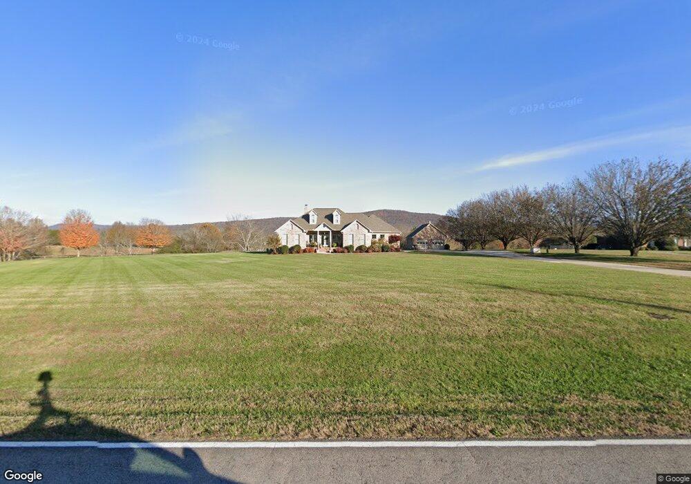
546 Hurricane Creek Rd Gurley, AL 35748
Estimated Value: $384,000 - $548,000
--
Bed
--
Bath
2,688
Sq Ft
$171/Sq Ft
Est. Value
About This Home
This home is located at 546 Hurricane Creek Rd, Gurley, AL 35748 and is currently estimated at $460,442, approximately $171 per square foot. 546 Hurricane Creek Rd is a home with nearby schools including Central School and Madison County High School.
Ownership History
Date
Name
Owned For
Owner Type
Purchase Details
Closed on
Jul 1, 2011
Sold by
Carter Steve and Carter Karla C
Bought by
Smith William W and Smith Mechelle C
Current Estimated Value
Home Financials for this Owner
Home Financials are based on the most recent Mortgage that was taken out on this home.
Original Mortgage
$250,000
Outstanding Balance
$18,877
Interest Rate
4.62%
Mortgage Type
New Conventional
Estimated Equity
$441,566
Create a Home Valuation Report for This Property
The Home Valuation Report is an in-depth analysis detailing your home's value as well as a comparison with similar homes in the area
Home Values in the Area
Average Home Value in this Area
Purchase History
| Date | Buyer | Sale Price | Title Company |
|---|---|---|---|
| Smith William W | -- | None Available |
Source: Public Records
Mortgage History
| Date | Status | Borrower | Loan Amount |
|---|---|---|---|
| Open | Smith William W | $250,000 |
Source: Public Records
Tax History Compared to Growth
Tax History
| Year | Tax Paid | Tax Assessment Tax Assessment Total Assessment is a certain percentage of the fair market value that is determined by local assessors to be the total taxable value of land and additions on the property. | Land | Improvement |
|---|---|---|---|---|
| 2024 | $1,444 | $40,640 | $7,720 | $32,920 |
| 2023 | $1,412 | $39,740 | $7,720 | $32,020 |
| 2022 | $1,167 | $33,720 | $5,240 | $28,480 |
| 2021 | $1,055 | $30,640 | $5,240 | $25,400 |
| 2020 | $991 | $28,880 | $5,230 | $23,650 |
| 2019 | $959 | $28,010 | $5,230 | $22,780 |
| 2018 | $892 | $26,160 | $0 | $0 |
| 2017 | $892 | $26,160 | $0 | $0 |
| 2016 | $892 | $26,160 | $0 | $0 |
| 2015 | $892 | $26,160 | $0 | $0 |
| 2014 | $884 | $25,940 | $0 | $0 |
Source: Public Records
Map
Nearby Homes
- 218 Powell St
- 211 Powell St
- 221 Grasslands Rd
- 0 Gilliam Rd
- 309 Gilliam Rd
- 216 Grasslands Rd
- 102 Peyton Cir
- 1519 Ryland Pike
- 107 Nolan Dr
- 3608 Maysville Rd NE
- 172 Day Dr
- 3 acres Hurricane Creek Rd
- 2095 Hurricane Creek Rd
- 111 Cool Cir
- 477 Moontown Rd
- 362 Moontown Rd
- 350 Moontown Rd
- 506 Moontown Rd
- 124 Jodie Dr
- 293 Neal Dr
- 510 Hurricane Creek Rd
- 596 Hurricane Creek Rd
- 486 Hurricane Creek Rd
- 588 Hurricane Creek Rd
- 578 Hurricane Creek Rd
- 595 Hurricane Creek Rd
- 590 Hurricane Creek Rd
- 109 Creekview Dr
- 434 Hurricane Creek Rd
- 223 Poplar Glen
- 225 Poplar Glen
- 110 Creekview Dr
- 221 Poplar Glen
- 100 Jasper Dr
- 219 Poplar Glen
- 104 Jasper Dr
- 229 Poplar Glen
- 227 Poplar Glen Dr
- 217 Poplar Glen
- 102 Jasper Dr