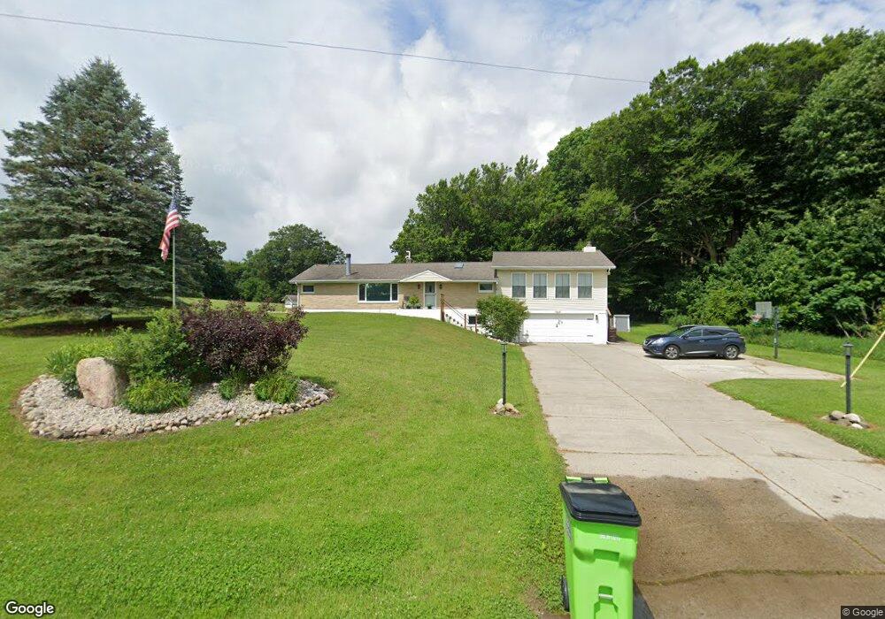
5467 N Comstock Ave Hesperia, MI 49421
Estimated Value: $292,000 - $377,000
Studio
3
Baths
2,158
Sq Ft
$155/Sq Ft
Est. Value
About This Home
This home is located at 5467 N Comstock Ave, Hesperia, MI 49421 and is currently estimated at $333,471, approximately $154 per square foot. 5467 N Comstock Ave is a home located in Newaygo County with nearby schools including Patricia St. Clair Elementary School, Hesperia Middle School, and Hesperia High School.
Ownership History
Date
Name
Owned For
Owner Type
Purchase Details
Closed on
Aug 17, 2007
Sold by
Perkins Robin
Bought by
Proctor Nicholas J
Current Estimated Value
Purchase Details
Closed on
Jul 31, 2007
Sold by
Perkins Jack Richard
Bought by
Ward Robin Lesli
Purchase Details
Closed on
Nov 7, 2003
Sold by
Williamson Mary M
Bought by
Ward Robin and Ward Beverly I
Purchase Details
Closed on
Dec 18, 1998
Sold by
Assoc Home Equity Serv
Bought by
Williamson Arthur K
Create a Home Valuation Report for This Property
The Home Valuation Report is an in-depth analysis detailing your home's value as well as a comparison with similar homes in the area
Purchase History
| Date | Buyer | Sale Price | Title Company |
|---|---|---|---|
| Proctor Nicholas J | $99,000 | -- | |
| Ward Robin Lesli | -- | -- | |
| Ward Robin | $139,900 | Metropolitan Title Company | |
| Ward Robin | $139,900 | -- | |
| Williamson Arthur K | $117,500 | -- |
Source: Public Records
Tax History
| Year | Tax Paid | Tax Assessment Tax Assessment Total Assessment is a certain percentage of the fair market value that is determined by local assessors to be the total taxable value of land and additions on the property. | Land | Improvement |
|---|---|---|---|---|
| 2025 | $674 | $150,500 | $0 | $0 |
| 2024 | $7 | $108,700 | $0 | $0 |
| 2023 | $629 | $80,000 | $0 | $0 |
| 2022 | $1,609 | $69,100 | $0 | $0 |
| 2021 | $1,565 | $67,600 | $0 | $0 |
| 2020 | $1,601 | $67,800 | $0 | $0 |
| 2019 | $1,572 | $66,100 | $0 | $0 |
| 2018 | $1,536 | $48,400 | $0 | $0 |
| 2017 | $1,508 | $54,200 | $0 | $0 |
| 2016 | $1,480 | $58,500 | $0 | $0 |
| 2015 | -- | $52,800 | $0 | $0 |
| 2014 | -- | $46,300 | $0 | $0 |
Source: Public Records
Map
Nearby Homes
- 5525 N Comstock Ave
- 9586 E Lure Rd
- 5993 W Crepin Ln
- 0 E Springhill Unit 8
- 8119 N Sweet Chevy Ln
- 8159 N Sweet Chevy Ln
- 8808 E Pierce Rd
- 1837 S 200th Ave
- 1945 S 200th Ave
- VL State St
- 00 V/L Comstock Ave Unit Par B
- 7365 Jefferson St
- 7830 Jefferson St
- 6878 N Croswell Ave
- V L Comstock Ave
- 4969 W 11 Mile Ave
- 1908 S 186th Ave
- 3593 S Maple Island Rd
- 6766 E Gale Rd
- 8473 W 1 Mile Rd
- 5423 N Comstock Ave
- 8060 7 Mile Rd
- 8038 7 Mile Rd
- 8106 7 Mile Rd
- 8188 7 Mile Rd
- 5342 N Comstock Ave
- 5393 N Comstock Ave
- 5272 N Comstock Ave
- 8500 7 Mile Rd
- 0 7 Mile Rd
- 8421 7 Mile Rd
- 5992 N Comstock Ave
- 5631 N Green Ave
- 6060 N Comstock Ave
- 4904 N Comstock Ave
- 5196 N Dickinson Ave
- 4693 N Comstock Ave
- 5292 N Dickinson Ave
- 5362 N Dickinson Ave
- 5766 N Dickinson Ave
Your Personal Tour Guide
Ask me questions while you tour the home.