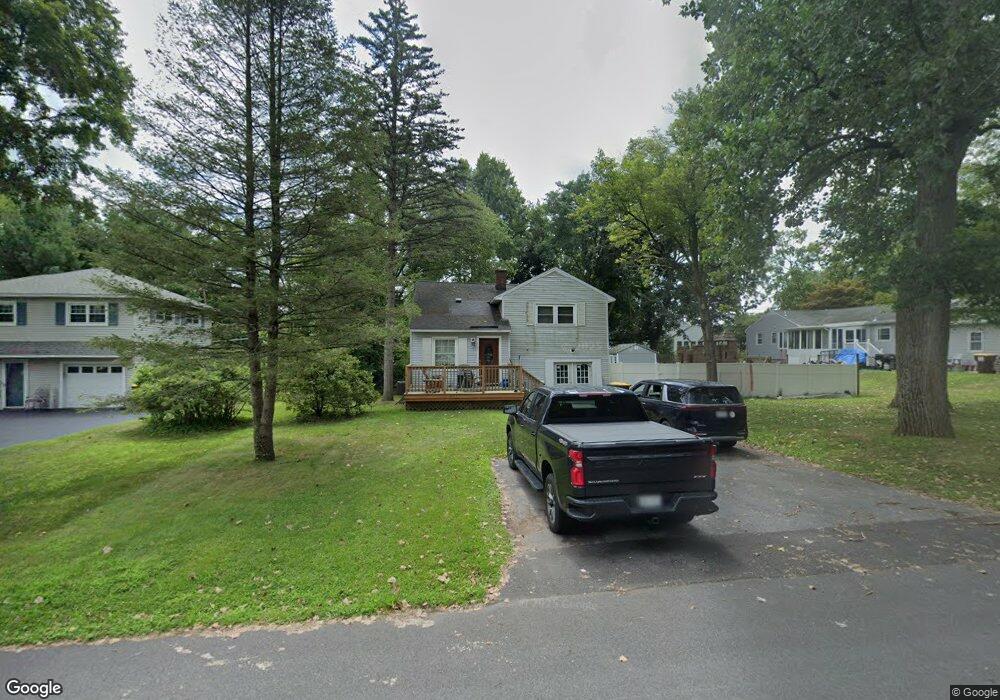
547 Dawson Rd Delmar, NY 12054
Estimated Value: $391,000 - $456,000
3
Beds
2
Baths
1,778
Sq Ft
$233/Sq Ft
Est. Value
About This Home
This home is located at 547 Dawson Rd, Delmar, NY 12054 and is currently estimated at $413,980, approximately $232 per square foot. 547 Dawson Rd is a home located in Albany County with nearby schools including St. Thomas the Apostle School and Academy of the Holy Names.
Ownership History
Date
Name
Owned For
Owner Type
Purchase Details
Closed on
Jul 21, 2010
Sold by
Butler Kathleen A
Bought by
Wagner Steven
Current Estimated Value
Home Financials for this Owner
Home Financials are based on the most recent Mortgage that was taken out on this home.
Original Mortgage
$204,397
Outstanding Balance
$136,028
Interest Rate
4.75%
Mortgage Type
FHA
Estimated Equity
$277,952
Purchase Details
Closed on
Sep 10, 2007
Sold by
Butler Jon
Bought by
Butler Kathleen
Purchase Details
Closed on
May 23, 1998
Create a Home Valuation Report for This Property
The Home Valuation Report is an in-depth analysis detailing your home's value as well as a comparison with similar homes in the area
Home Values in the Area
Average Home Value in this Area
Purchase History
| Date | Buyer | Sale Price | Title Company |
|---|---|---|---|
| Wagner Steven | $209,000 | None Available | |
| Butler Kathleen | -- | Michelle Rosien | |
| Butler Kathleen A | -- | None Available | |
| -- | -- | -- |
Source: Public Records
Mortgage History
| Date | Status | Borrower | Loan Amount |
|---|---|---|---|
| Open | Wagner Steven | $204,397 |
Source: Public Records
Tax History Compared to Growth
Tax History
| Year | Tax Paid | Tax Assessment Tax Assessment Total Assessment is a certain percentage of the fair market value that is determined by local assessors to be the total taxable value of land and additions on the property. | Land | Improvement |
|---|---|---|---|---|
| 2024 | $6,706 | $209,000 | $61,500 | $147,500 |
| 2023 | $6,156 | $209,000 | $61,500 | $147,500 |
| 2022 | $6,071 | $209,000 | $61,500 | $147,500 |
| 2021 | $6,104 | $209,000 | $61,500 | $147,500 |
| 2020 | $5,955 | $209,000 | $61,500 | $147,500 |
| 2019 | $5,727 | $209,000 | $61,500 | $147,500 |
| 2018 | $5,819 | $209,000 | $61,500 | $147,500 |
| 2017 | $5,727 | $209,000 | $61,500 | $147,500 |
| 2016 | $5,727 | $209,000 | $61,500 | $147,500 |
| 2015 | -- | $209,000 | $61,500 | $147,500 |
| 2014 | -- | $209,000 | $61,500 | $147,500 |
Source: Public Records
Map
Nearby Homes
- 532 Wayne Place
- 531 Delaware Ave
- 481 Huron Rd
- 515 Delaware Ave
- 3 Longmeadow Dr
- 47 Oldox Rd
- 1 Van Dyke Rd
- 82 Brockley Dr
- 29 Bennett Terrace
- 11 Wakefield Ct
- 117 Brockley Dr
- 19 Orchard St
- 23 Canterbury Ln
- 484 Kenwood Ave
- 10 Canterbury Ln
- 616 Kenwood Ave
- 15 Roweland Ave
- 618 Kenwood Ave
- 20 Gardner Terrace
- 21 Roweland Ave