
Seller's Agent in 2025
Dennis Leandres
RE/MAX
(774) 406-1794
1 in this area
12 Total Sales
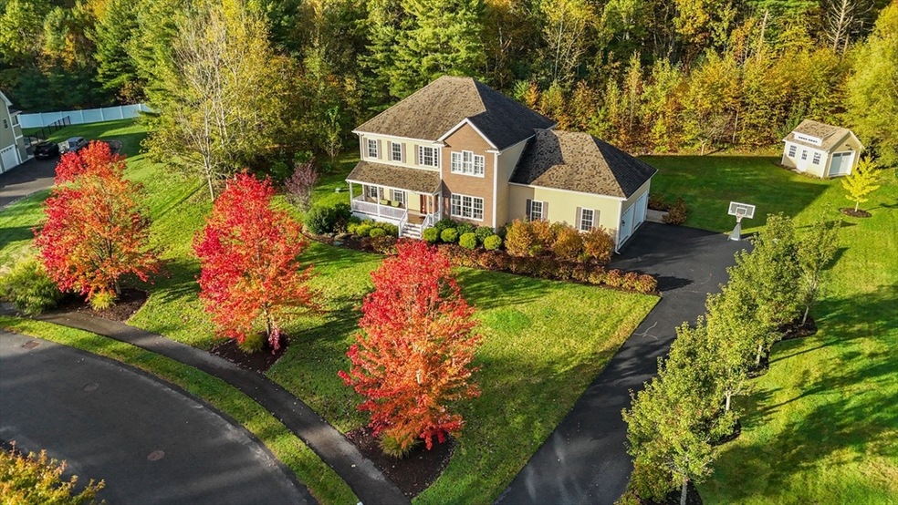
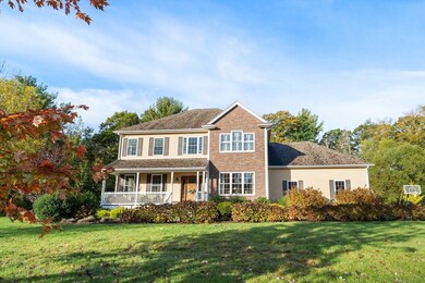
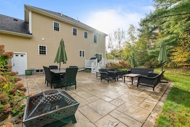
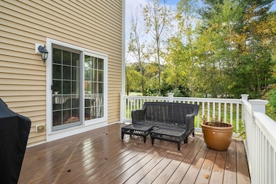
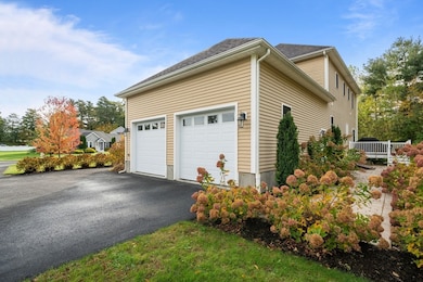
Welcome to your new home!! Situated in a beautiful 7 home development, sits this Colonial, built in 2015 on 1.88 acres of land in the quiet town of Dighton. Two car garage with over 2,300 square feet. Once inside this 4 BR 2 1/2 BA home, you will be greeted with hardwood floors and recess lighting throughout. The first floor has an open kitchen with granite countertops, an island, and stainless-steel appliances. The dining room is the perfect size to host family and friends. Leading to the kitchen is a half bath and walk-in pantry with enough room to store all your groceries and more. The living room has a propane fireplace which is open to the kitchen making it easy to entertain guests. Second floor has all 4 bedrooms which makes life easier with kiddos. The main bedroom has a walk-in closet and a full bath. 3 bedrooms, laundry room, and another full bath wrap up the second floor. Basement is more than partially finished! Irrigation, shed, AC, patio and deck.
| Date | Type | Sale Price | Title Company |
|---|---|---|---|
| Quit Claim Deed | $790,000 | -- | |
| Quit Claim Deed | -- | None Available | |
| Quit Claim Deed | -- | -- | |
| Quit Claim Deed | $439,000 | -- |
| Date | Status | Loan Amount | Loan Type |
|---|---|---|---|
| Open | $440,000 | New Conventional | |
| Previous Owner | $351,200 | New Conventional |
| Date | Event | Price | List to Sale | Price per Sq Ft |
|---|---|---|---|---|
| 12/01/2025 12/01/25 | Sold | $790,000 | 0.0% | $331 / Sq Ft |
| 10/29/2025 10/29/25 | Pending | -- | -- | -- |
| 10/21/2025 10/21/25 | For Sale | $789,900 | -- | $331 / Sq Ft |
| Year | Tax Paid | Tax Assessment Tax Assessment Total Assessment is a certain percentage of the fair market value that is determined by local assessors to be the total taxable value of land and additions on the property. | Land | Improvement |
|---|---|---|---|---|
| 2025 | $8,802 | $700,800 | $140,800 | $560,000 |
| 2024 | $8,571 | $626,500 | $138,100 | $488,400 |
| 2023 | $7,912 | $567,600 | $138,100 | $429,500 |
| 2022 | $7,541 | $527,700 | $134,600 | $393,100 |
| 2021 | $7,153 | $482,300 | $122,000 | $360,300 |
| 2020 | $7,035 | $469,600 | $136,000 | $333,600 |
| 2019 | $6,939 | $462,900 | $136,000 | $326,900 |
| 2018 | $6,485 | $436,100 | $115,900 | $320,200 |
| 2017 | $5,921 | $396,300 | $134,200 | $262,100 |
| 2016 | $5,772 | $379,000 | $138,100 | $240,900 |
| 2015 | $2,102 | $142,000 | $142,000 | $0 |
| 2014 | $2,163 | $142,000 | $142,000 | $0 |
Seller's Agent in 2025
Dennis Leandres
RE/MAX
(774) 406-1794
1 in this area
12 Total Sales
Buyer's Agent in 2025
Lori Seavey
Keller Williams Elite
(508) 446-1258
2 in this area
302 Total Sales
Source: MLS Property Information Network (MLS PIN)
MLS Number: 73446217
APN: DIGH-000017-000109-000030
Disclaimer: Certain information contained herein is derived from information provided by parties other than Homes.com. All information provided is deemed reliable, but is not guaranteed to be accurate and should be independently verified.
![]() The property listing data and information, or the Images, set forth herein were provided to MLS Property Information Network, Inc. from third party sources, including sellers, lessors and public records, and were compiled by MLS Property Information Network, Inc. The property listing data and information, and the Images, are for the personal, non-commercial use of consumers having a good faith interest in purchasing or leasing listed properties of the type displayed to them and may not be used for any purpose other than to identify prospective properties which such consumers may have a good faith interest in purchasing or leasing. MLS Property Information Network, Inc. and its subscribers disclaim any and all representations and warranties as to the accuracy of the property listing data and information, or as to the accuracy of any of the Images, set forth herein.
The property listing data and information, or the Images, set forth herein were provided to MLS Property Information Network, Inc. from third party sources, including sellers, lessors and public records, and were compiled by MLS Property Information Network, Inc. The property listing data and information, and the Images, are for the personal, non-commercial use of consumers having a good faith interest in purchasing or leasing listed properties of the type displayed to them and may not be used for any purpose other than to identify prospective properties which such consumers may have a good faith interest in purchasing or leasing. MLS Property Information Network, Inc. and its subscribers disclaim any and all representations and warranties as to the accuracy of the property listing data and information, or as to the accuracy of any of the Images, set forth herein.
Ask me questions while you tour the home.