5470 State Hwy Eastham, MA 2642
Estimated payment $1,850/month
Highlights
- Marina
- Golf Course Community
- 1.33 Acre Lot
- Nauset Regional High School Rated A-
- Medical Services
- Property is near public transit
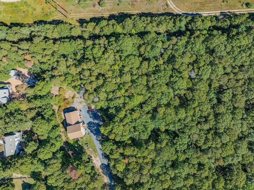
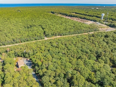
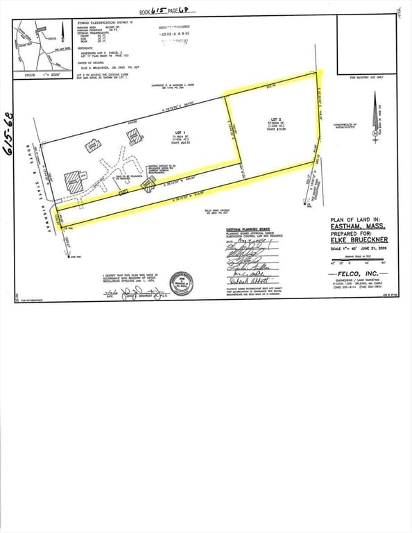
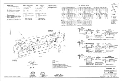
About This Lot
A rare find in North Eastham, this 1.3-acre level lot presents the perfect canvas for your dream home. Backing up to the scenic Cape Cod Rail Trail, and set over 600 feet from the road, this parcel is said to support a 4-bedroom septic design, with town water and natural gas at the street. Enjoy all that Eastham has to offer: the National Seashore, Nauset Light, and beautiful beaches including: Nauset Light Beach, Coast Guard Beach, First Encounter Beach and Marconi Beach.
Property Details
Property Type
- Land
Est. Annual Taxes
- $1,682
Lot Details
- 1.33 Acre Lot
- Level Lot
- Wooded Lot
- Property is zoned RES & LTD
Location
- Property is near public transit
- Property is near schools
Utilities
- Private Sewer
Listing and Financial Details
- Assessor Parcel Number 4730289
Community Details
Overview
- No Home Owners Association
- Near Conservation Area
Amenities
- Medical Services
- Shops
Recreation
- Marina
- Golf Course Community
- Park
- Jogging Path
- Bike Trail
- Electricity Available at Street
Map
Home Values in the Area
Average Home Value in this Area
Tax History
| Year | Tax Paid | Tax Assessment Tax Assessment Total Assessment is a certain percentage of the fair market value that is determined by local assessors to be the total taxable value of land and additions on the property. | Land | Improvement |
|---|---|---|---|---|
| 2025 | $1,682 | $218,200 | $218,200 | $0 |
| 2024 | $1,485 | $211,800 | $211,800 | $0 |
| 2023 | $1,492 | $206,100 | $206,100 | $0 |
| 2022 | $1,578 | $183,900 | $183,900 | $0 |
| 2021 | $1,640 | $178,600 | $178,600 | $0 |
| 2020 | $1,590 | $182,300 | $182,300 | $0 |
| 2019 | $1,504 | $182,300 | $182,300 | $0 |
| 2018 | $1,477 | $176,900 | $176,900 | $0 |
| 2017 | $1,375 | $174,000 | $174,000 | $0 |
| 2016 | $1,286 | $172,800 | $172,800 | $0 |
| 2015 | $1,215 | $171,100 | $171,100 | $0 |
Property History
| Date | Event | Price | List to Sale | Price per Sq Ft | Prior Sale |
|---|---|---|---|---|---|
| 09/05/2025 09/05/25 | For Sale | $325,000 | +47.8% | -- | |
| 08/13/2021 08/13/21 | Sold | $219,900 | 0.0% | -- | View Prior Sale |
| 06/17/2021 06/17/21 | Pending | -- | -- | -- | |
| 06/13/2021 06/13/21 | For Sale | $219,900 | -- | -- |
Purchase History
| Date | Type | Sale Price | Title Company |
|---|---|---|---|
| Not Resolvable | $219,900 | None Available | |
| Deed | -- | -- |
Mortgage History
| Date | Status | Loan Amount | Loan Type |
|---|---|---|---|
| Open | $175,920 | Purchase Money Mortgage |
Source: MLS Property Information Network (MLS PIN)
MLS Number: 73426733
APN: EAST-000005-000000-000002B
Disclaimer: Certain information contained herein is derived from information provided by parties other than Homes.com. All information provided is deemed reliable, but is not guaranteed to be accurate and should be independently verified.
![]() The property listing data and information, or the Images, set forth herein were provided to MLS Property Information Network, Inc. from third party sources, including sellers, lessors and public records, and were compiled by MLS Property Information Network, Inc. The property listing data and information, and the Images, are for the personal, non-commercial use of consumers having a good faith interest in purchasing or leasing listed properties of the type displayed to them and may not be used for any purpose other than to identify prospective properties which such consumers may have a good faith interest in purchasing or leasing. MLS Property Information Network, Inc. and its subscribers disclaim any and all representations and warranties as to the accuracy of the property listing data and information, or as to the accuracy of any of the Images, set forth herein.
The property listing data and information, or the Images, set forth herein were provided to MLS Property Information Network, Inc. from third party sources, including sellers, lessors and public records, and were compiled by MLS Property Information Network, Inc. The property listing data and information, and the Images, are for the personal, non-commercial use of consumers having a good faith interest in purchasing or leasing listed properties of the type displayed to them and may not be used for any purpose other than to identify prospective properties which such consumers may have a good faith interest in purchasing or leasing. MLS Property Information Network, Inc. and its subscribers disclaim any and all representations and warranties as to the accuracy of the property listing data and information, or as to the accuracy of any of the Images, set forth herein.
- 100 Gigi Ln
- 95 Toland Dr
- 140 Harvest Rd
- 160 Toland Dr
- 49 Village Ln
- 11 Whelpley Rd
- 495 Aspinet Rd
- 1460 Massasoit Rd
- 46 Spring Brook Rd
- 1285 Massasoit Rd
- 115 Sparrowhawk Ln
- 50 Silver Oak Rd
- 72 Dory Ln
- 35 Old County Rd Unit 1
- 15 Old Bay Rd
- 340 Salt Works Rd
- 100 Orchard Dr
- 255 Massasoit Rd
- 157 Brownell Rd
- 90 Blue Heron Rd
- 12 Seavers Rd
- 80 Cranberry Hwy Unit 1
- 19 West Rd
- 5 Commons Way
- 873 Harwich Rd
- 101 Monomoyic Way
- 175 Sam Ryder Rd
- 26 Cranwood Rd
- 328 Bank St
- 328 Bank St Unit 4
- 328 Bank St Unit 21
- 6 Ruth Ln
- 253 Main St Unit 6
- 41 Bank St Unit 13
- 25 Embassy Ln
- 25 Embassy St
- 221 Upper County Rd Unit 2A
- 451 Main St Unit 2
- 56 Center St Unit 2-3
- 265 Commercial St
