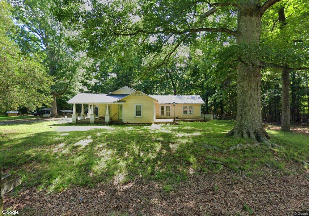
548 Atlantic Rd Robbins, NC 27325
Estimated Value: $112,000 - $191,000
3
Beds
1
Bath
1,380
Sq Ft
$116/Sq Ft
Est. Value
About This Home
This home is located at 548 Atlantic Rd, Robbins, NC 27325 and is currently estimated at $160,280, approximately $116 per square foot. 548 Atlantic Rd is a home located in Moore County with nearby schools including Robbins Elementary School, Elise Middle School, and North Moore High School.
Ownership History
Date
Name
Owned For
Owner Type
Purchase Details
Closed on
Aug 21, 2008
Sold by
Chriscoe Gene Roger and Chriscoe Carolyn Ann
Bought by
Womack David R
Current Estimated Value
Home Financials for this Owner
Home Financials are based on the most recent Mortgage that was taken out on this home.
Original Mortgage
$45,000
Interest Rate
6.21%
Mortgage Type
Unknown
Purchase Details
Closed on
Jan 17, 1997
Sold by
Chriscoe Gene Roger and Chriscoe Car
Bought by
Womack David R
Create a Home Valuation Report for This Property
The Home Valuation Report is an in-depth analysis detailing your home's value as well as a comparison with similar homes in the area
Purchase History
| Date | Buyer | Sale Price | Title Company |
|---|---|---|---|
| Womack David R | $50,000 | None Available | |
| Womack David R | $24,000 | -- |
Source: Public Records
Mortgage History
| Date | Status | Borrower | Loan Amount |
|---|---|---|---|
| Closed | Womack David R | $45,000 |
Source: Public Records
Tax History
| Year | Tax Paid | Tax Assessment Tax Assessment Total Assessment is a certain percentage of the fair market value that is determined by local assessors to be the total taxable value of land and additions on the property. | Land | Improvement |
|---|---|---|---|---|
| 2025 | $330 | $78,610 | $21,030 | $57,580 |
| 2024 | $342 | $78,610 | $21,030 | $57,580 |
| 2023 | $358 | $78,610 | $21,030 | $57,580 |
| 2022 | $354 | $56,210 | $15,010 | $41,200 |
| 2021 | $368 | $56,210 | $15,010 | $41,200 |
| 2020 | $363 | $54,840 | $15,010 | $39,830 |
| 2019 | $363 | $56,210 | $15,010 | $41,200 |
| 2018 | $304 | $50,630 | $14,020 | $36,610 |
| 2017 | $296 | $50,630 | $14,020 | $36,610 |
| 2015 | $286 | $50,630 | $14,020 | $36,610 |
| 2014 | $327 | $59,740 | $24,860 | $34,880 |
| 2013 | -- | $59,740 | $24,860 | $34,880 |
Source: Public Records
Map
Nearby Homes
- tbd Flint Hill Church Rd
- Tbd Plank Rd
- 260 E Elm St
- 260 Lick Creek Dr
- 101 N Rockingham St
- 131 N Middleton St
- 27 N Carolina 24
- 546 Noah Rd
- 1280 Leaman Rd
- Lot 4 Leaman Rd
- 107 Browns Mill Rd
- 1246 Browns Mill Rd
- 344 Manley Rd
- TBD Alton Rd
- 1204 Winfred Brady Rd
- Tbd Herman Ln
- Lot 1 Winfred Brady Rd
- Lot 2 Winfred Brady Rd
- 4115 Busbee Rd
- 2592 Old Glendon Rd
- 545 Atlantic Rd
- 512 Atlantic Rd
- 568 Atlantic Rd
- 152 Allwood Ln
- 127 Allwood Ln
- 0 Atlantic Rd
- 336 Apple Orchard Rd
- 336 Atlantic Rd
- 288 Atlantic Rd
- 264 Apple Orchard Rd
- 582 Lonnie Rd
- 656 Lonnie Rd
- 440 Lonnie Rd
- 580 Lonnie Rd
- 477 Lonnie Rd
- 21+ Acre Letlough Rd
- 1312 Lakey Siding Rd
- 106 Apple Orchard Rd
- 440 Letlough Rd
- 329 Lonnie Rd
Your Personal Tour Guide
Ask me questions while you tour the home.