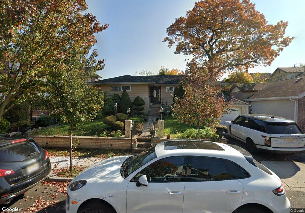
548 Saint Pauls Ave Cliffside Park, NJ 07010
Estimated Value: $768,000 - $809,000
--
Bed
--
Bath
1,993
Sq Ft
$395/Sq Ft
Est. Value
About This Home
This home is located at 548 Saint Pauls Ave, Cliffside Park, NJ 07010 and is currently estimated at $787,622, approximately $395 per square foot. 548 Saint Pauls Ave is a home located in Bergen County with nearby schools including Cliffside Park High School.
Ownership History
Date
Name
Owned For
Owner Type
Purchase Details
Closed on
Dec 12, 2014
Sold by
Abdelhady Musa Z and Abdelhady Maysoun
Bought by
Abdelhady Maysoun
Current Estimated Value
Purchase Details
Closed on
Dec 6, 2002
Sold by
Cundari Joseph
Bought by
Cundari Giuseppa
Purchase Details
Closed on
Sep 5, 1996
Sold by
Martinez Lilia and Martinez Arturo
Bought by
Abdelhady Musa Z and Abdelhady Maysoun
Home Financials for this Owner
Home Financials are based on the most recent Mortgage that was taken out on this home.
Original Mortgage
$162,000
Interest Rate
8.18%
Create a Home Valuation Report for This Property
The Home Valuation Report is an in-depth analysis detailing your home's value as well as a comparison with similar homes in the area
Home Values in the Area
Average Home Value in this Area
Purchase History
| Date | Buyer | Sale Price | Title Company |
|---|---|---|---|
| Abdelhady Maysoun | -- | None Available | |
| Cundari Giuseppa | -- | -- | |
| Abdelhady Musa Z | $216,500 | -- |
Source: Public Records
Mortgage History
| Date | Status | Borrower | Loan Amount |
|---|---|---|---|
| Previous Owner | Abdelhady Musa Z | $162,000 |
Source: Public Records
Tax History Compared to Growth
Tax History
| Year | Tax Paid | Tax Assessment Tax Assessment Total Assessment is a certain percentage of the fair market value that is determined by local assessors to be the total taxable value of land and additions on the property. | Land | Improvement |
|---|---|---|---|---|
| 2025 | $9,660 | $350,500 | $260,000 | $90,500 |
| 2024 | $9,379 | $350,500 | $260,000 | $90,500 |
| 2023 | $8,990 | $350,500 | $260,000 | $90,500 |
| 2022 | $8,990 | $350,500 | $260,000 | $90,500 |
| 2021 | $7,975 | $350,500 | $260,000 | $90,500 |
| 2020 | $8,720 | $350,500 | $260,000 | $90,500 |
| 2019 | $8,559 | $350,500 | $260,000 | $90,500 |
| 2018 | $8,545 | $350,500 | $260,000 | $90,500 |
| 2017 | $8,384 | $350,500 | $260,000 | $90,500 |
| 2016 | $8,219 | $350,500 | $260,000 | $90,500 |
| 2015 | $7,974 | $350,500 | $260,000 | $90,500 |
| 2014 | $9,082 | $410,600 | $260,000 | $150,600 |
Source: Public Records
Map
Nearby Homes
- 562 Oregon Ave
- 580 Oregon Ave
- 515 Saint Pauls Ave
- 533 Highridge Ave
- 465 Oakdene Ave
- 475 Oakdene Ave Unit 2
- 393 Lincoln Ave
- 476 Lincoln Ave Unit 1
- 476 Lincoln Ave Unit 2
- 542 Anderson Ave
- 539 Bergen Blvd
- 647 Anderson Ave
- 555 Edgewater Ave Unit 103 Reserve Ct.
- 555 Gorge Rd Unit 6F
- 555 Gorge Rd Unit 2E
- 451 Wilfred Terrace
- 401 Park Ave
- 200 Division St Unit 3F
- 485 Columbia Ave
- 2 Kathleen Ct Unit C002
- 550 Saint Pauls Ave
- 550 Saint Pauls Ave Unit 1
- 552 Saint Pauls Ave
- 409 Greenmount Ave
- 411 Greenmount Ave
- 407 Greenmount Ave
- 545 Oregon Ave
- 549 Oregon Ave
- 405 Greenmount Ave
- 405 Greenmount Ave Unit 2
- 553 Oregon Ave
- 556 Saint Pauls Ave
- 537 Saint Pauls Ave
- 555 Oregon Ave
- 401 Greenmount Ave
- 547 Saint Pauls Ave
- 549 Saint Pauls Ave
- 551 Saint Pauls Ave
- 415 Greenmount Ave
- 558 Saint Pauls Ave