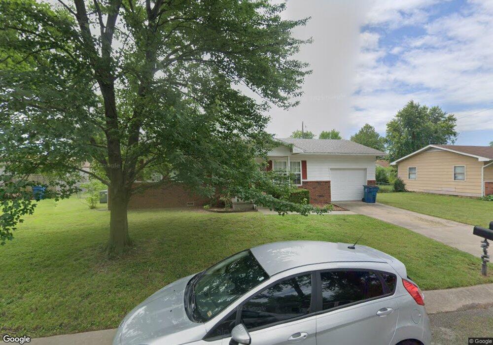
548 Steve St Carthage, MO 64836
Estimated Value: $141,000 - $162,000
3
Beds
1
Bath
1,138
Sq Ft
$130/Sq Ft
Est. Value
About This Home
This home is located at 548 Steve St, Carthage, MO 64836 and is currently estimated at $147,756, approximately $129 per square foot. 548 Steve St is a home located in Jasper County with nearby schools including Carthage High School, St. Ann's Catholic School, and Victory Academy.
Ownership History
Date
Name
Owned For
Owner Type
Purchase Details
Closed on
Nov 5, 2021
Sold by
Cory Jaime E and Dunaway Jaime E
Bought by
Cory Dakota
Current Estimated Value
Home Financials for this Owner
Home Financials are based on the most recent Mortgage that was taken out on this home.
Original Mortgage
$101,010
Outstanding Balance
$91,580
Interest Rate
2.99%
Mortgage Type
New Conventional
Estimated Equity
$56,176
Purchase Details
Closed on
Nov 7, 2017
Sold by
Dodson David L and Dodson Lois E
Bought by
Cory Jaime E
Home Financials for this Owner
Home Financials are based on the most recent Mortgage that was taken out on this home.
Original Mortgage
$87,373
Interest Rate
3.91%
Mortgage Type
New Conventional
Purchase Details
Closed on
Apr 2, 2012
Sold by
Lowe Pickering Linda and Lowe Porter Linda C
Bought by
Dodson David L
Create a Home Valuation Report for This Property
The Home Valuation Report is an in-depth analysis detailing your home's value as well as a comparison with similar homes in the area
Home Values in the Area
Average Home Value in this Area
Purchase History
| Date | Buyer | Sale Price | Title Company |
|---|---|---|---|
| Cory Dakota | -- | None Listed On Document | |
| Cory Dakota | -- | None Listed On Document | |
| Cory Jaime E | -- | None Available | |
| Cory Jaime E | -- | None Available | |
| Dodson David L | -- | Fatco |
Source: Public Records
Mortgage History
| Date | Status | Borrower | Loan Amount |
|---|---|---|---|
| Open | Cory Dakota | $101,010 | |
| Closed | Cory Dakota | $101,010 | |
| Previous Owner | Cory Jaime E | $87,373 |
Source: Public Records
Tax History
| Year | Tax Paid | Tax Assessment Tax Assessment Total Assessment is a certain percentage of the fair market value that is determined by local assessors to be the total taxable value of land and additions on the property. | Land | Improvement |
|---|---|---|---|---|
| 2025 | $574 | $12,510 | $2,010 | $10,500 |
| 2024 | $574 | $11,160 | $2,010 | $9,150 |
| 2023 | $574 | $11,160 | $2,010 | $9,150 |
| 2022 | $564 | $11,510 | $2,010 | $9,500 |
| 2021 | $564 | $11,510 | $2,010 | $9,500 |
| 2020 | $564 | $10,660 | $2,010 | $8,650 |
| 2019 | $565 | $10,660 | $2,010 | $8,650 |
| 2018 | $586 | $11,070 | $0 | $0 |
| 2017 | $587 | $11,070 | $0 | $0 |
| 2016 | $619 | $11,700 | $0 | $0 |
| 2015 | $572 | $11,700 | $0 | $0 |
| 2014 | $572 | $11,700 | $0 | $0 |
Source: Public Records
Map
Nearby Homes
- TBD Hazel Ave
- 510 W Fairview Ave
- 509 W Highland Ave
- 1830 S Maple St
- 000 Annie Baxter & George Phelps
- SEC Hazel & Phelps Unit 1
- SEC Hazel & Phelps Unit 2
- 1615 Forest St
- 2206 Benjamin Dr
- 1746 Robertson Ave
- 1710 Robertson Ave
- 1732 Robertson Ave
- 1702 Robertson Ave
- 1736 Robertson Ave
- 1720 Robertson Ave
- 1740 Robertson Ave
- 1716 Robertson Ave
- 1373 W Fairview Ave
- XXXX Clinton
- 303 W Centennial Ave
- 540 Steve St
- 554 Steve St
- 541-563 W Scott
- 549 Steve St
- 557 Scott St
- 534 Steve St
- 547 Scott St
- 562 Steve St
- 555 Steve St
- 541 Steve St
- 533 Scott St Unit 535
- 541 Scott St
- 555 Scott St Unit 563
- 561 Scott St
- 563 Steve St
- 535 Steve St
- 546 Scott St Unit 548
- 2039 Forest Dr
- 540 Scott St Unit 542
- 554 Scott St Unit 556
Your Personal Tour Guide
Ask me questions while you tour the home.