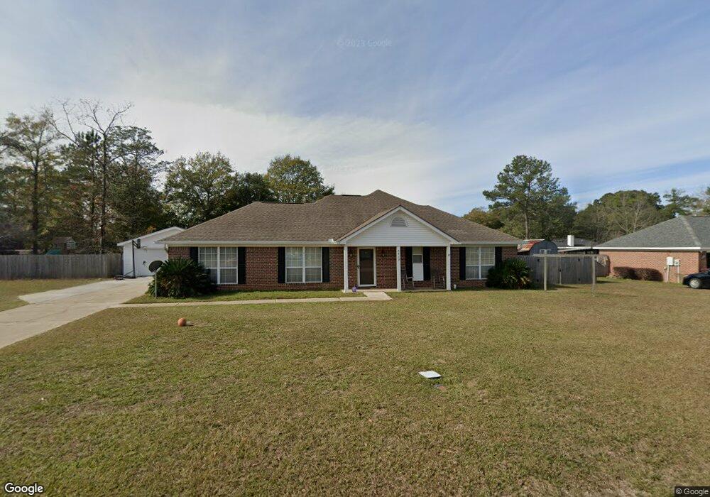
5489 Maple Ct Satsuma, AL 36572
Estimated Value: $228,279 - $268,000
3
Beds
2
Baths
1,702
Sq Ft
$147/Sq Ft
Est. Value
About This Home
This home is located at 5489 Maple Ct, Satsuma, AL 36572 and is currently estimated at $250,070, approximately $146 per square foot. 5489 Maple Ct is a home located in Mobile County with nearby schools including Robert E. Lee Elementary School, Satsuma High School, and Satsuma Christian School.
Ownership History
Date
Name
Owned For
Owner Type
Purchase Details
Closed on
Jun 14, 2024
Sold by
Beasley Mark Gregory and Beasley Brandi Pitts
Bought by
Pitts Vickie J and Beasley Mark Gregory
Current Estimated Value
Home Financials for this Owner
Home Financials are based on the most recent Mortgage that was taken out on this home.
Original Mortgage
$100,000
Outstanding Balance
$98,475
Interest Rate
7.09%
Mortgage Type
New Conventional
Estimated Equity
$151,595
Purchase Details
Closed on
Feb 15, 2017
Sold by
Pitts Vickie J
Bought by
Beasley Mark Gregory and Beasley Brandi Pitts
Purchase Details
Closed on
Jul 24, 2002
Sold by
Benchmark Homes Inc
Bought by
Pitts Dennis G and Pitts Vickie J
Home Financials for this Owner
Home Financials are based on the most recent Mortgage that was taken out on this home.
Original Mortgage
$92,270
Interest Rate
6.62%
Mortgage Type
FHA
Create a Home Valuation Report for This Property
The Home Valuation Report is an in-depth analysis detailing your home's value as well as a comparison with similar homes in the area
Home Values in the Area
Average Home Value in this Area
Purchase History
| Date | Buyer | Sale Price | Title Company |
|---|---|---|---|
| Pitts Vickie J | $239,500 | None Listed On Document | |
| Beasley Mark Gregory | $140,000 | None Available | |
| Pitts Dennis G | $93,000 | -- |
Source: Public Records
Mortgage History
| Date | Status | Borrower | Loan Amount |
|---|---|---|---|
| Open | Pitts Vickie J | $100,000 | |
| Previous Owner | Pitts Dennis G | $92,270 |
Source: Public Records
Tax History
| Year | Tax Paid | Tax Assessment Tax Assessment Total Assessment is a certain percentage of the fair market value that is determined by local assessors to be the total taxable value of land and additions on the property. | Land | Improvement |
|---|---|---|---|---|
| 2025 | $935 | $16,400 | $2,400 | $14,000 |
| 2024 | $935 | $16,580 | $2,400 | $14,180 |
| 2023 | $946 | $15,620 | $2,000 | $13,620 |
| 2022 | $832 | $14,740 | $2,000 | $12,740 |
| 2021 | $737 | $13,180 | $1,600 | $11,580 |
| 2020 | $744 | $13,300 | $1,600 | $11,700 |
| 2019 | $792 | $14,080 | $0 | $0 |
| 2018 | $800 | $14,220 | $0 | $0 |
| 2017 | $731 | $13,080 | $0 | $0 |
| 2016 | $752 | $13,420 | $0 | $0 |
| 2013 | $603 | $10,880 | $0 | $0 |
Source: Public Records
Map
Nearby Homes
- 150 Orange Ave E
- 212 Jill Ln
- 204 Bayou Ave E
- 5303 U S 43
- 0 Willie Crook Ave
- 251 Tajuacha Dr S
- 5503 Darring St
- 0 Travelers Ct Unit 34 315632
- 6 Oak Ave
- 5450 Timberland Dr
- 5617 Orchard St
- 0 Orchard St
- 0 Kalifield Blvd Unit 7706300
- 212 Pine Ave W
- 0 Travellers Ct Unit 34
- 5719 Warrior Dr
- 5718 Apache Dr
- 302 Hummingbird Dr N
- 5859 Northgate Dr W
- 0 Baldwin Rd
Your Personal Tour Guide
Ask me questions while you tour the home.