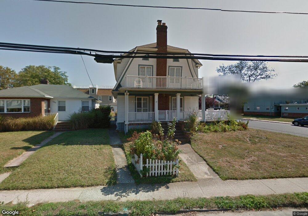
549 2nd Ave Long Branch, NJ 07740
Estimated Value: $868,000 - $1,071,000
4
Beds
3
Baths
1,824
Sq Ft
$514/Sq Ft
Est. Value
About This Home
This home is located at 549 2nd Ave, Long Branch, NJ 07740 and is currently estimated at $936,831, approximately $513 per square foot. 549 2nd Ave is a home located in Monmouth County with nearby schools including Long Branch High School, Holy Trinity School, and Bet Yaakov of the Jersey Shore.
Ownership History
Date
Name
Owned For
Owner Type
Purchase Details
Closed on
Sep 4, 2002
Sold by
Leavy Thomas
Bought by
Greenwald Harry and Greenwald Maxine
Current Estimated Value
Purchase Details
Closed on
Jul 25, 1994
Sold by
Dellavia Cinzio
Bought by
Leavy Thomas and Leavy Kimberly
Home Financials for this Owner
Home Financials are based on the most recent Mortgage that was taken out on this home.
Original Mortgage
$89,000
Interest Rate
8.25%
Create a Home Valuation Report for This Property
The Home Valuation Report is an in-depth analysis detailing your home's value as well as a comparison with similar homes in the area
Home Values in the Area
Average Home Value in this Area
Purchase History
| Date | Buyer | Sale Price | Title Company |
|---|---|---|---|
| Greenwald Harry | $320,000 | -- | |
| Leavy Thomas | $94,000 | -- |
Source: Public Records
Mortgage History
| Date | Status | Borrower | Loan Amount |
|---|---|---|---|
| Previous Owner | Leavy Thomas | $89,000 |
Source: Public Records
Tax History Compared to Growth
Tax History
| Year | Tax Paid | Tax Assessment Tax Assessment Total Assessment is a certain percentage of the fair market value that is determined by local assessors to be the total taxable value of land and additions on the property. | Land | Improvement |
|---|---|---|---|---|
| 2025 | $11,106 | $762,400 | $420,800 | $341,600 |
| 2024 | $9,826 | $722,600 | $395,800 | $326,800 |
| 2023 | $9,826 | $632,700 | $320,800 | $311,900 |
| 2022 | $8,750 | $539,700 | $264,900 | $274,800 |
| 2021 | $8,750 | $449,800 | $192,900 | $256,900 |
| 2020 | $8,974 | $429,400 | $173,900 | $255,500 |
| 2019 | $9,001 | $428,200 | $173,900 | $254,300 |
| 2018 | $8,940 | $422,900 | $177,900 | $245,000 |
| 2017 | $8,454 | $410,200 | $169,900 | $240,300 |
| 2016 | $8,266 | $409,000 | $174,900 | $234,100 |
| 2015 | $7,309 | $328,200 | $86,300 | $241,900 |
| 2014 | $6,861 | $324,700 | $110,100 | $214,600 |
Source: Public Records
Map
Nearby Homes
- 107 W End Ave
- 119 Avery Ave Unit H21
- 510 Ocean Ave N Unit 10
- 480 Ocean Ave Unit 2K
- 464 2nd Ave
- 21 Riviera Dr
- 17 Tower Rd Unit D2
- 665 2nd Ave Unit 309
- 665 2nd Ave Unit 202
- 665 2nd Ave Unit 310
- 665 2nd Ave Unit 303
- 665 2nd Ave Unit 201
- 14 Tower Rd
- 675 Ocean Ave Unit 9F
- 675 Ocean Ave Unit 5J
- 675 Ocean Ave Unit 4I
- 12 Coral Place
- 65 Cedar Ave Unit C11
- 392 Ocean Ave Unit 1302
- 392 Ocean Ave Unit 1608
- 543 2nd Ave
- 541 2nd Ave
- 544 2nd Ave
- 539 2nd Ave
- 550 2nd Ave
- 55 Passey Gardens
- 552 2nd Ave
- 60 Passey Gardens
- 525 2nd Ave
- 53 Passey Gardens
- 532 2nd Ave
- 532 2nd Ave Unit 1
- 540 2nd Ave
- 58 Passey Gardens
- 11 Howland Ave
- 51 Passey Gardens
- 9 Howland Ave
- 9 Howland Ave Unit 2
- 9 Howland Ave Unit 1
- 56 Passey Gardens