
M
Seller's Agent in 2025
Maria Giakoumakis
Pierre Peloquin Realty
(603) 703-1252
8 in this area
24 Total Sales

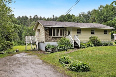
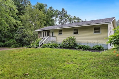
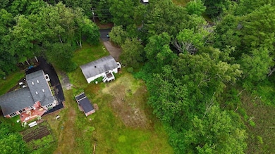
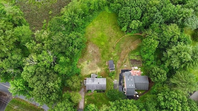

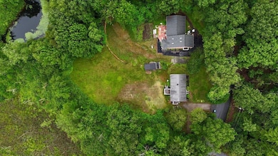
LOOK NO FURTHER...Charming 3 bedroom 1 bath ranch in the highly sought-after community of Windham. This home offers a fantastic opportunity for buyers looking to put their personal touch and sweat equity into their property. This home is situated on over an acre with a nice level lot, large shed and would be perfect for outdoor entertaining or gardening. The home is conveniently located near local amenities, parks, top-rated schools & easy access to 93 making it a prime location for families and commuters alike. Don't miss out on this affordable opportunity in town.
Last Agent to Sell the Property
Pierre Peloquin Realty License #066395 Listed on: 07/11/2025
| Date | Type | Sale Price | Title Company |
|---|---|---|---|
| Warranty Deed | $425,000 | -- | |
| Warranty Deed | $425,000 | -- | |
| Warranty Deed | $425,000 | -- | |
| Warranty Deed | $471,000 | -- | |
| Warranty Deed | $471,000 | -- | |
| Warranty Deed | $471,000 | -- |
| Date | Status | Loan Amount | Loan Type |
|---|---|---|---|
| Open | $403,750 | New Conventional | |
| Closed | $403,750 | New Conventional | |
| Previous Owner | $470,000 | New Conventional |
| Date | Event | Price | List to Sale | Price per Sq Ft |
|---|---|---|---|---|
| 08/28/2025 08/28/25 | Sold | $425,000 | -3.4% | $385 / Sq Ft |
| 07/11/2025 07/11/25 | For Sale | $440,000 | -- | $399 / Sq Ft |
| Year | Tax Paid | Tax Assessment Tax Assessment Total Assessment is a certain percentage of the fair market value that is determined by local assessors to be the total taxable value of land and additions on the property. | Land | Improvement |
|---|---|---|---|---|
| 2024 | $7,616 | $336,400 | $176,300 | $160,100 |
| 2023 | $7,199 | $336,400 | $176,300 | $160,100 |
| 2022 | $8,493 | $429,800 | $184,800 | $245,000 |
| 2021 | $8,003 | $429,800 | $184,800 | $245,000 |
| 2020 | $8,222 | $429,800 | $184,800 | $245,000 |
| 2019 | $9,397 | $416,700 | $169,700 | $247,000 |
| 2018 | $9,705 | $416,700 | $169,700 | $247,000 |
| 2017 | $8,415 | $416,600 | $169,700 | $246,900 |
| 2016 | $9,090 | $416,600 | $169,700 | $246,900 |
| 2015 | $9,064 | $417,300 | $169,700 | $247,600 |
| 2014 | $8,141 | $339,200 | $175,000 | $164,200 |
| 2013 | $7,524 | $318,800 | $175,000 | $143,800 |
M
Seller's Agent in 2025
Maria Giakoumakis
Pierre Peloquin Realty
(603) 703-1252
8 in this area
24 Total Sales
A
Buyer's Agent in 2025
Alanna Brush
Keller Williams Gateway Realty/Salem
(603) 912-5470
1 in this area
4 Total Sales
Source: PrimeMLS
MLS Number: 5051126
APN: WNDM-000007-A000000-001900
Disclaimer: Certain information contained herein is derived from information provided by parties other than Homes.com. All information provided is deemed reliable, but is not guaranteed to be accurate and should be independently verified.
![]() Copyright 2026 PrimeMLS, Inc. All rights reserved. This information is deemed reliable, but not guaranteed. The data relating to real estate displayed on this display comes in part from the IDX Program of PrimeMLS. The information being provided is for consumers’ personal, non-commercial use and may not be used for any purpose other than to identify prospective properties consumers may be interested in purchasing.
Copyright 2026 PrimeMLS, Inc. All rights reserved. This information is deemed reliable, but not guaranteed. The data relating to real estate displayed on this display comes in part from the IDX Program of PrimeMLS. The information being provided is for consumers’ personal, non-commercial use and may not be used for any purpose other than to identify prospective properties consumers may be interested in purchasing.
Ask me questions while you tour the home.