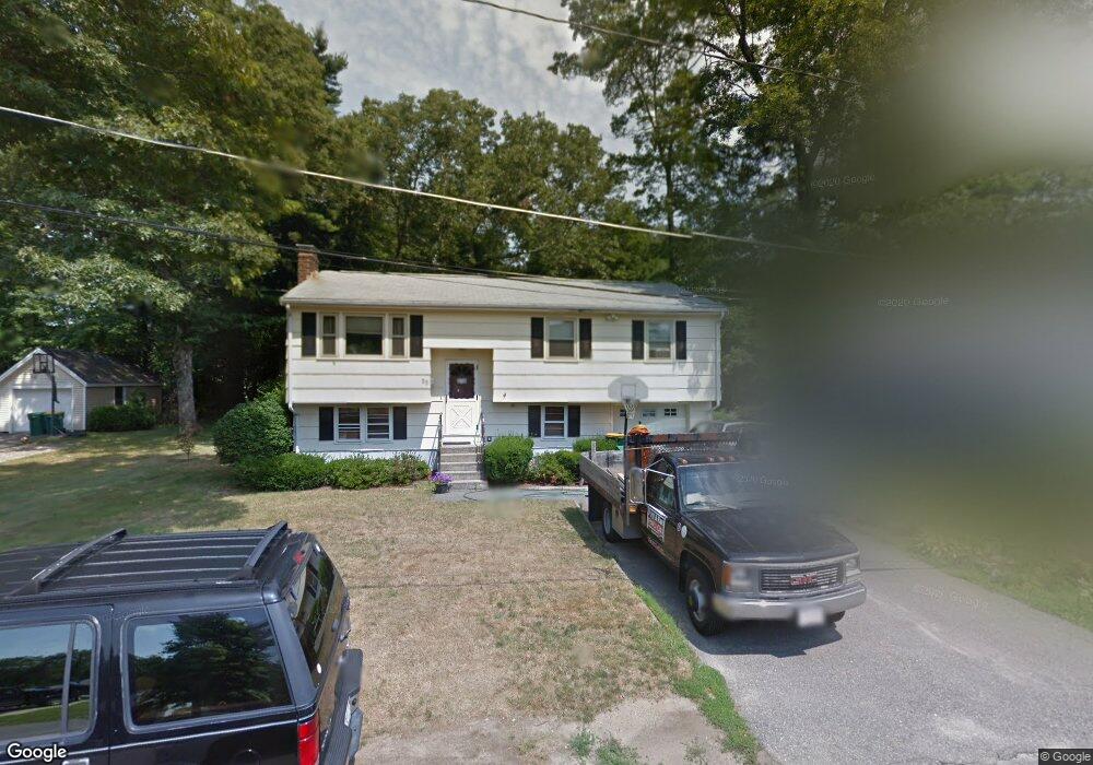
55 Campbell St Mansfield, MA 02048
Estimated Value: $559,000 - $652,000
3
Beds
1
Bath
1,028
Sq Ft
$578/Sq Ft
Est. Value
About This Home
This home is located at 55 Campbell St, Mansfield, MA 02048 and is currently estimated at $594,422, approximately $578 per square foot. 55 Campbell St is a home located in Bristol County with nearby schools including Everett W. Robinson Elementary School, Jordan/Jackson Elementary School, and Harold L. Qualters Middle School.
Ownership History
Date
Name
Owned For
Owner Type
Purchase Details
Closed on
Apr 2, 2004
Sold by
Medio Steven F and Medio Linda J
Bought by
Oram Joseph J and Oram Kimberly J
Current Estimated Value
Home Financials for this Owner
Home Financials are based on the most recent Mortgage that was taken out on this home.
Original Mortgage
$185,000
Interest Rate
5.56%
Mortgage Type
Purchase Money Mortgage
Purchase Details
Closed on
Mar 30, 2000
Sold by
Long Jeremiah F and Long Caroline R
Bought by
Medio Steven F and Medio Linda J
Home Financials for this Owner
Home Financials are based on the most recent Mortgage that was taken out on this home.
Original Mortgage
$158,500
Interest Rate
8.4%
Mortgage Type
Purchase Money Mortgage
Create a Home Valuation Report for This Property
The Home Valuation Report is an in-depth analysis detailing your home's value as well as a comparison with similar homes in the area
Home Values in the Area
Average Home Value in this Area
Purchase History
| Date | Buyer | Sale Price | Title Company |
|---|---|---|---|
| Oram Joseph J | $315,000 | -- | |
| Medio Steven F | $186,500 | -- |
Source: Public Records
Mortgage History
| Date | Status | Borrower | Loan Amount |
|---|---|---|---|
| Open | Medio Steven F | $170,000 | |
| Closed | Oram Joseph J | $185,000 | |
| Previous Owner | Medio Steven F | $158,500 | |
| Previous Owner | Medio Steven F | $158,500 | |
| Previous Owner | Medio Steven F | $42,000 |
Source: Public Records
Tax History Compared to Growth
Tax History
| Year | Tax Paid | Tax Assessment Tax Assessment Total Assessment is a certain percentage of the fair market value that is determined by local assessors to be the total taxable value of land and additions on the property. | Land | Improvement |
|---|---|---|---|---|
| 2025 | $6,115 | $464,300 | $219,500 | $244,800 |
| 2024 | $5,858 | $433,900 | $219,500 | $214,400 |
| 2023 | $5,728 | $406,500 | $219,500 | $187,000 |
| 2022 | $5,548 | $365,700 | $203,300 | $162,400 |
| 2021 | $0 | $336,000 | $177,800 | $158,200 |
| 2020 | $2,245 | $331,800 | $169,400 | $162,400 |
| 2019 | $4,621 | $303,600 | $141,200 | $162,400 |
| 2018 | $0 | $284,400 | $134,500 | $149,900 |
| 2017 | $0 | $283,300 | $130,600 | $152,700 |
| 2016 | $4,205 | $272,900 | $124,400 | $148,500 |
| 2015 | $3,908 | $252,100 | $124,400 | $127,700 |
Source: Public Records
Map
Nearby Homes
- 450 West St
- 150 Rumford Ave Unit 222
- 241-243 N Main St
- 22 Pleasant St Unit B
- 22 Pleasant St Unit A
- 28 Court St
- 28 Court St Unit 4
- 38 Court St
- 16 East St Unit 2
- 21 East St Unit 1D
- 76 Samoset Ave
- 72 Court St Unit B
- 132 S High St
- 99 Pleasant St
- 28 Angell St
- 356 Central St
- 12 Wilson Place
- 60 King St
- 82 Brook St
- 115 S High St
- 51 Campbell St
- 61 Campbell St
- 52 Henry St
- 54 Campbell St
- 58 Campbell St
- 41 Campbell St
- 56 Henry St
- 46 Henry St
- 64 Campbell St
- 50 Creeden St
- 71 Campbell St
- 56 Creeden St
- 71 Fowler St Unit 73
- 67-69 Fowler St Unit 69
- 67 Fowler St Unit 69
- 67 Fowler St Unit 69
- 62 Creeden St
- 68 Creeden St
- 55 Fowler St
- 68 Campbell St