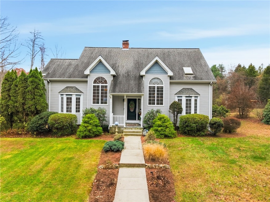


55 Gentry Way North Scituate, RI 02857
Estimated payment $5,026/month
Highlights
- 3.86 Acre Lot
- Cathedral Ceiling
- Attic
- Cape Cod Architecture
- Wood Flooring
- Home Office
About This Home
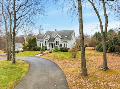
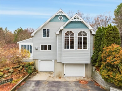
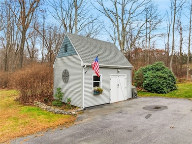
Welcome to this exceptionally spacious Cape-style home in the desirable Scituate Village Estates neighborhood. Set on an extremely private lot of nearly 4 acres, this property features mature landscaping, perennial gardens, flowering trees, 13 Japanese Maples, a circular driveway, peaceful water garden, tucked-away pergola, and a spacious shed. Inside, the home offers 4 bedrooms, 2.5 baths, and a functional layout. The main level includes a large primary bedroom with full bath and double closets, a half bath, and laundry. The bright living room flows seamlessly into a generous dining area and features cathedral ceilings, a striking combination of tall arch and bow windows along the front fa ade, and a cozy wood-burning fireplace that anchors the space with warmth and charm. The updated kitchen offers granite counters, stainless steel appliances, and generous storage. An informal dining area off the kitchen with gas fireplace opens to a charming 3-season room, paver patio, and porch overlooking the serene grounds. Upstairs are 3 additional bedrooms with new Berber carpeting and a full bath. The finished basement adds even more flexibility with a rec room and separate office space perfect for work, hobbies, or extra living area. Additional perks include a 2-car garage, low-maintenance vinyl siding, and oil heat with new Roth double-wall stainless steel tank. This exceptional property offers beauty, privacy, and comfort in one of Scituate's most sought after settings.
Listing Agent
J. Christopher Real Estate Grp License #REB.0200116 Listed on: 11/24/2025
Home Details
Home Type
- Single Family
Est. Annual Taxes
- $8,386
Year Built
- Built in 1988
Lot Details
- 3.86 Acre Lot
- Property is zoned RR-120
Parking
- 2 Car Attached Garage
- Driveway
Home Design
- Cape Cod Architecture
- Vinyl Siding
- Concrete Perimeter Foundation
Interior Spaces
- 3-Story Property
- Central Vacuum
- Cathedral Ceiling
- Fireplace Features Masonry
- Thermal Windows
- Family Room
- Living Room
- Dining Room
- Home Office
- Utility Room
- Security System Leased
- Attic
Kitchen
- Oven
- Range
- Microwave
- Dishwasher
Flooring
- Wood
- Carpet
- Ceramic Tile
- Vinyl
Bedrooms and Bathrooms
- 4 Bedrooms
- Bathtub with Shower
Laundry
- Laundry Room
- Dryer
- Washer
Finished Basement
- Basement Fills Entire Space Under The House
- Interior and Exterior Basement Entry
Accessible Home Design
- Low Pile Carpeting
Outdoor Features
- Outbuilding
- Porch
Utilities
- No Cooling
- Zoned Heating
- Heating System Uses Oil
- Baseboard Heating
- Hot Water Heating System
- 200+ Amp Service
- Power Generator
- Private Water Source
- Well
- Tankless Water Heater
- Oil Water Heater
- Septic Tank
Community Details
- Scituate Village Estates Subdivision
Listing and Financial Details
- Tax Lot 084
- Assessor Parcel Number 55GENTRYWYSCIT
Map
Home Values in the Area
Average Home Value in this Area
Tax History
| Year | Tax Paid | Tax Assessment Tax Assessment Total Assessment is a certain percentage of the fair market value that is determined by local assessors to be the total taxable value of land and additions on the property. | Land | Improvement |
|---|---|---|---|---|
| 2025 | $8,259 | $476,600 | $159,300 | $317,300 |
| 2024 | $8,259 | $476,600 | $159,300 | $317,300 |
| 2023 | $7,988 | $476,600 | $159,300 | $317,300 |
| 2022 | $7,807 | $476,600 | $159,300 | $317,300 |
| 2021 | $6,534 | $413,800 | $133,100 | $280,700 |
| 2020 | $7,560 | $413,800 | $133,100 | $280,700 |
| 2019 | $7,403 | $413,800 | $133,100 | $280,700 |
| 2018 | $7,504 | $387,000 | $135,000 | $252,000 |
| 2017 | $7,283 | $387,000 | $135,000 | $252,000 |
| 2016 | $6,981 | $387,000 | $135,000 | $252,000 |
| 2015 | $6,804 | $355,100 | $119,400 | $235,700 |
| 2014 | $6,740 | $355,100 | $119,400 | $235,700 |
Property History
| Date | Event | Price | List to Sale | Price per Sq Ft |
|---|---|---|---|---|
| 11/24/2025 11/24/25 | For Sale | $824,900 | -- | $300 / Sq Ft |
Purchase History
| Date | Type | Sale Price | Title Company |
|---|---|---|---|
| Quit Claim Deed | -- | -- | |
| Quit Claim Deed | -- | -- | |
| Warranty Deed | $300,000 | -- | |
| Warranty Deed | $300,000 | -- |
Mortgage History
| Date | Status | Loan Amount | Loan Type |
|---|---|---|---|
| Previous Owner | $86,599 | No Value Available | |
| Previous Owner | $141,070 | No Value Available | |
| Previous Owner | $150,000 | No Value Available | |
| Closed | $150,000 | No Value Available |
Source: State-Wide MLS
MLS Number: 1400780
APN: SCIT-000034-000084-000000
Disclaimer: Certain information contained herein is derived from information provided by parties other than Homes.com. All information provided is deemed reliable, but is not guaranteed to be accurate and should be independently verified.
![]() IDX information is provided exclusively for personal, non-commercial use, and may not be used for any purpose other than to identify prospective properties consumers may be interested in purchasing. Information is deemed reliable but not guaranteed.
IDX information is provided exclusively for personal, non-commercial use, and may not be used for any purpose other than to identify prospective properties consumers may be interested in purchasing. Information is deemed reliable but not guaranteed.
Copyright © 2025 State-Wide MLS, Inc. All rights reserved.
- 737 Danielson Pike
- 278 Central Pike
- 785 Danielson Pike
- 255 Rockland Rd
- 0 Dexter Rd
- 67 Dexter Rd
- 86 Central Pike
- 1101 Danielson Pike
- 607 Elmdale Rd
- 261 Quaker Ln
- 0 Quaker Ln
- 399 Bungy Rd
- 34 Highland Terrace
- 58 Highland Terrace
- 955 Chopmist Hill Rd
- 389 Elmdale Rd
- 0 Danielson Pike Unit 1347736
- 1224 Hartford Pike
- 1240 Hartford Pike
- 15 Apple Hill Dr
- 22 Gleaner Chapel Rd
- 155C Danielson Pike Unit First Floor 1 Bed
- 2465 Hartford Ave
- 1 Boss Rd
- 1 Boss Rd Unit 6
- 633 Chestnut Hill Rd
- 42 Belfield Dr
- 494 Putnam Pike
- 14 Woodlake Dr
- 34 Cedar Swamp Rd Unit 2
- 5 Apple Valley Pkwy
- 100 Linda Cir Unit 1
- 200 Charlie's Way Unit 1
- 125 Federal Way
- 1535 Atwood Ave
- 363 Simmonsville Ave
- 9 Shadow Brook Ln
- 8 Deluca St Unit A
- 92 Dean Ave
- 23 Starr St Unit D
