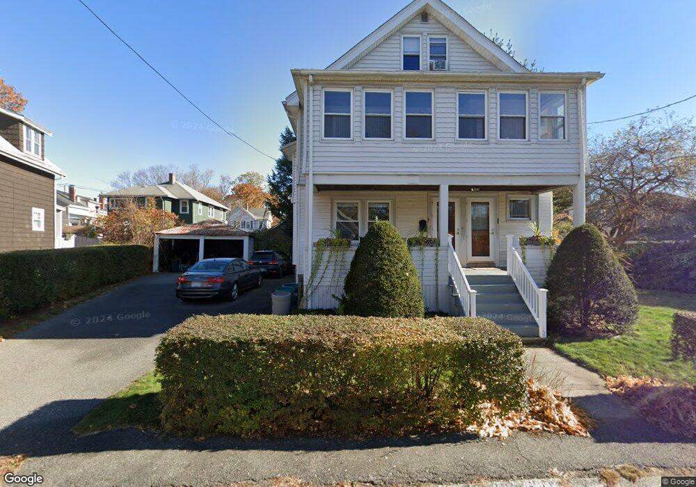
55 Leonard Rd Unit 57 Melrose, MA 02176
Downtown Melrose NeighborhoodEstimated Value: $872,000 - $1,055,000
6
Beds
2
Baths
2,424
Sq Ft
$401/Sq Ft
Est. Value
About This Home
This home is located at 55 Leonard Rd Unit 57, Melrose, MA 02176 and is currently estimated at $972,676, approximately $401 per square foot. 55 Leonard Rd Unit 57 is a home located in Middlesex County with nearby schools including Lincoln Elementary School, Winthrop Elementary School, and Horace Mann Elementary School.
Ownership History
Date
Name
Owned For
Owner Type
Purchase Details
Closed on
Jan 26, 1996
Sold by
Keshian James H and Keshian Elaine
Bought by
Okeefe Michael P
Current Estimated Value
Home Financials for this Owner
Home Financials are based on the most recent Mortgage that was taken out on this home.
Original Mortgage
$172,000
Outstanding Balance
$5,695
Interest Rate
7.13%
Mortgage Type
Purchase Money Mortgage
Estimated Equity
$966,981
Create a Home Valuation Report for This Property
The Home Valuation Report is an in-depth analysis detailing your home's value as well as a comparison with similar homes in the area
Home Values in the Area
Average Home Value in this Area
Purchase History
We collect this data history from publicly available records. To have your information removed, we recommend requesting removal directly through your county’s website.
| Date | Buyer | Sale Price | Title Company |
|---|---|---|---|
| Okeefe Michael P | $215,000 | -- |
Source: Public Records
Mortgage History
We collect this data history from publicly available records. To have your information removed, we recommend requesting removal directly through your county’s website.
| Date | Status | Borrower | Loan Amount |
|---|---|---|---|
| Open | Okeefe Michael P | $172,000 | |
| Open | Okeefe Michael P | $280,000 | |
| Previous Owner | Okeefe Michael P | $28,300 |
Source: Public Records
Tax History
| Year | Tax Paid | Tax Assessment Tax Assessment Total Assessment is a certain percentage of the fair market value that is determined by local assessors to be the total taxable value of land and additions on the property. | Land | Improvement |
|---|---|---|---|---|
| 2025 | $75 | $760,100 | $428,000 | $332,100 |
| 2024 | $7,086 | $713,600 | $400,400 | $313,200 |
| 2023 | $7,077 | $679,200 | $372,800 | $306,400 |
| 2022 | $6,923 | $655,000 | $359,000 | $296,000 |
| 2021 | $6,695 | $611,400 | $345,200 | $266,200 |
| 2020 | $6,413 | $580,400 | $317,500 | $262,900 |
| 2019 | $6,040 | $558,700 | $303,700 | $255,000 |
| 2018 | $5,647 | $498,400 | $252,000 | $246,400 |
| 2017 | $5,554 | $470,700 | $241,600 | $229,100 |
| 2016 | $5,144 | $417,200 | $214,000 | $203,200 |
| 2015 | $5,183 | $399,900 | $214,000 | $185,900 |
| 2014 | $5,081 | $382,600 | $196,700 | $185,900 |
Source: Public Records
Map
Nearby Homes
- 395 Lebanon St
- 71-73 Grove St
- 534 Main St Unit 11
- 12 Mount Vernon St Unit 25
- 167 Essex St
- 509 Pleasant St Unit 1-4
- 247 Lebanon St
- 228 Upham St
- 8 Crystal St Unit 2
- 8 Crystal St Unit 3
- 97 Trenton St
- 35 Frances St
- 16 Sanford St
- 26 Garfield Rd
- 25 Naples Rd
- 76 Wheeler Ave
- 6 Black Rock Rd
- 31 Temple St
- 639 Lynn Fells Pkwy
- 49 Melrose St Unit 4B
- 12 Dell Ave
- 14 Dell Ave
- 140 Grove St
- 138 Grove St
- 138 Grove St Unit 2
- 138 Grove St Unit 1
- 16 Dell Ave
- 2 Crescent Ct
- 9 Crescent Place
- 51 Leonard Rd
- 9 Dell Ave Unit 11
- 152 Grove St
- 13 Dell Ave Unit 15
- 3 Crescent Place
- 132 Grove St Unit 134
- 26 Dell Ave
- 156 Grove St
- 128 Grove St
- 55-57 Leonard Rd Unit 1
- 47 Leonard Rd
Your Personal Tour Guide
Ask me questions while you tour the home.