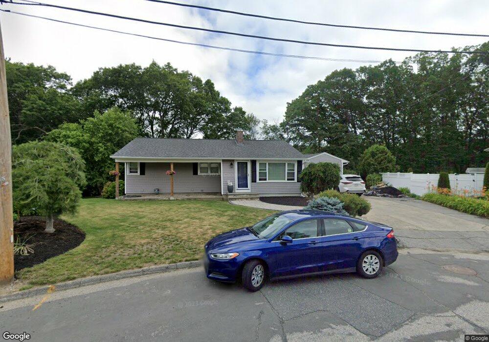
55 Maury Ln Shrewsbury, MA 01545
Estimated Value: $551,802 - $644,000
4
Beds
2
Baths
1,220
Sq Ft
$475/Sq Ft
Est. Value
About This Home
This home is located at 55 Maury Ln, Shrewsbury, MA 01545 and is currently estimated at $579,951, approximately $475 per square foot. 55 Maury Ln is a home located in Worcester County with nearby schools including Calvin Coolidge Elementary School, Sherwood Middle School, and Oak Middle School.
Ownership History
Date
Name
Owned For
Owner Type
Purchase Details
Closed on
Dec 2, 2003
Sold by
Simisky John A
Bought by
Staples Jeffrey P and Staples Mary F
Current Estimated Value
Home Financials for this Owner
Home Financials are based on the most recent Mortgage that was taken out on this home.
Original Mortgage
$249,850
Outstanding Balance
$115,634
Interest Rate
6.09%
Mortgage Type
Purchase Money Mortgage
Estimated Equity
$464,317
Purchase Details
Closed on
Sep 12, 2002
Sold by
Simisky Edward M and Simisky Johanna M
Bought by
Simisky John A
Home Financials for this Owner
Home Financials are based on the most recent Mortgage that was taken out on this home.
Original Mortgage
$160,000
Interest Rate
6.48%
Mortgage Type
Purchase Money Mortgage
Create a Home Valuation Report for This Property
The Home Valuation Report is an in-depth analysis detailing your home's value as well as a comparison with similar homes in the area
Home Values in the Area
Average Home Value in this Area
Purchase History
| Date | Buyer | Sale Price | Title Company |
|---|---|---|---|
| Staples Jeffrey P | $263,000 | -- | |
| Staples Jeffrey P | $263,000 | -- | |
| Staples Jeffrey P | $263,000 | -- | |
| Simisky John A | $160,000 | -- | |
| Simisky John A | $160,000 | -- |
Source: Public Records
Mortgage History
| Date | Status | Borrower | Loan Amount |
|---|---|---|---|
| Open | Staples Jeffrey P | $249,850 | |
| Closed | Staples Jeffrey P | $249,850 | |
| Previous Owner | Simisky John A | $163,350 | |
| Previous Owner | Simisky John A | $160,000 |
Source: Public Records
Tax History Compared to Growth
Tax History
| Year | Tax Paid | Tax Assessment Tax Assessment Total Assessment is a certain percentage of the fair market value that is determined by local assessors to be the total taxable value of land and additions on the property. | Land | Improvement |
|---|---|---|---|---|
| 2025 | $65 | $535,700 | $259,700 | $276,000 |
| 2024 | $5,790 | $467,700 | $247,300 | $220,400 |
| 2023 | $5,781 | $440,600 | $247,300 | $193,300 |
| 2022 | $5,971 | $423,200 | $247,300 | $175,900 |
| 2021 | $4,752 | $360,300 | $197,900 | $162,400 |
| 2020 | $4,418 | $354,300 | $197,900 | $156,400 |
| 2019 | $4,239 | $337,200 | $181,500 | $155,700 |
| 2018 | $3,995 | $315,600 | $173,800 | $141,800 |
| 2017 | $3,837 | $299,100 | $157,300 | $141,800 |
| 2016 | $3,632 | $279,400 | $147,300 | $132,100 |
| 2015 | $3,695 | $279,900 | $142,400 | $137,500 |
Source: Public Records
Map
Nearby Homes
- 45 -45A Kinglet Dr
- 76 Hillside Dr
- 190 S Quinsigamond Ave Unit 102
- 65 Edgewater Ave
- 259 S Quinsigamond Ave
- 94 Grove St
- 76 Grove St
- 105 S Quinsigamond Ave
- 42 Shrewsbury Green Dr Unit I
- 42 Shrewsbury Green Dr Unit F
- 22 Shrewsbury Green Dr Unit C
- 26 Williamsburg Ct Unit 22
- 28 Williamsburg Ct Unit 2
- 20 Williamsburg Ct Unit 21
- 18 Williamsburg Ct Unit 23
- 241 Lake Ave
- 6 Selina St
- 468 Grafton St
- 24 Sherbrook Ave
- 23 Canna Dr