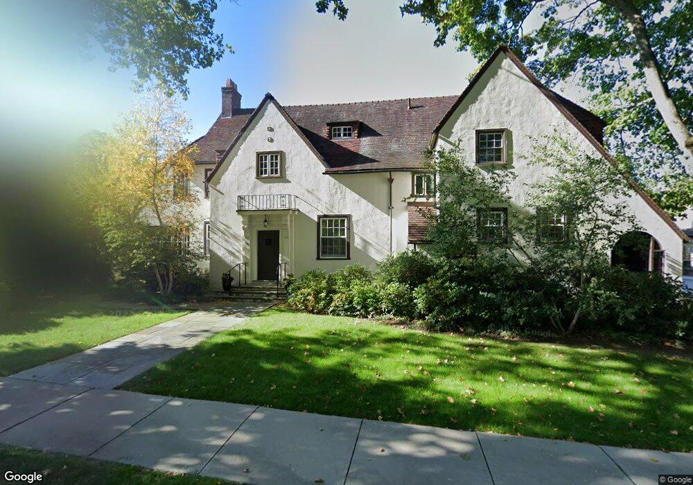
55 Penniman Rd Brookline, MA 02445
Chestnut Hill NeighborhoodEstimated Value: $3,578,000 - $3,861,000
5
Beds
6
Baths
4,135
Sq Ft
$900/Sq Ft
Est. Value
About This Home
This home is located at 55 Penniman Rd, Brookline, MA 02445 and is currently estimated at $3,720,086, approximately $899 per square foot. 55 Penniman Rd is a home located in Norfolk County with nearby schools including Heath Elementary School, Brookline High School, and Torah Academy.
Ownership History
Date
Name
Owned For
Owner Type
Purchase Details
Closed on
May 14, 1991
Sold by
Macdonald Palmina M
Bought by
Martland David A and Teresa A Martland
Current Estimated Value
Home Financials for this Owner
Home Financials are based on the most recent Mortgage that was taken out on this home.
Original Mortgage
$292,000
Interest Rate
9.35%
Create a Home Valuation Report for This Property
The Home Valuation Report is an in-depth analysis detailing your home's value as well as a comparison with similar homes in the area
Home Values in the Area
Average Home Value in this Area
Purchase History
| Date | Buyer | Sale Price | Title Company |
|---|---|---|---|
| Martland David A | $390,000 | -- |
Source: Public Records
Mortgage History
| Date | Status | Borrower | Loan Amount |
|---|---|---|---|
| Open | Martland David A | $150,000 | |
| Closed | Martland David A | $203,150 | |
| Closed | Martland David A | $202,300 | |
| Closed | Martland David A | $292,000 |
Source: Public Records
Tax History
| Year | Tax Paid | Tax Assessment Tax Assessment Total Assessment is a certain percentage of the fair market value that is determined by local assessors to be the total taxable value of land and additions on the property. | Land | Improvement |
|---|---|---|---|---|
| 2025 | $36,190 | $3,666,700 | $1,596,100 | $2,070,600 |
| 2024 | $34,547 | $3,536,000 | $1,534,700 | $2,001,300 |
| 2023 | $31,798 | $3,189,400 | $1,096,500 | $2,092,900 |
| 2022 | $30,952 | $3,037,500 | $1,044,300 | $1,993,200 |
| 2021 | $28,623 | $2,920,700 | $1,004,100 | $1,916,600 |
| 2020 | $26,527 | $2,807,100 | $912,800 | $1,894,300 |
| 2019 | $25,050 | $2,673,400 | $869,300 | $1,804,100 |
| 2018 | $23,512 | $2,485,400 | $880,500 | $1,604,900 |
| 2017 | $22,870 | $2,314,800 | $830,500 | $1,484,300 |
| 2016 | $22,542 | $2,163,300 | $776,200 | $1,387,100 |
| 2015 | $21,593 | $2,021,800 | $725,400 | $1,296,400 |
| 2014 | $21,699 | $1,905,100 | $659,500 | $1,245,600 |
Source: Public Records
Map
Nearby Homes
- 401 Clinton Rd
- 2400 Beacon St Unit 102
- 2400 Beacon St Unit 409
- 2420 Beacon St Unit 401
- 282 Buckminster Rd
- 43 Druce St
- 6 Sutherland Rd Unit 41
- 41 Orkney Rd
- 31 Orkney Rd Unit 54
- 34 Hyslop Rd
- 4 7 Englewood Ave
- 0 Kilsyth Rd
- 47 Englewood Ave
- 142 Crafts Rd
- 60 Sutherland Rd Unit 4
- 37 Englewood Ave Unit 3
- 120 Seaver St Unit C-102
- 26 Chiswick Rd Unit 6
- 5 Braemore Rd Unit 10
- 56-58 Selkirk Rd
Your Personal Tour Guide
Ask me questions while you tour the home.