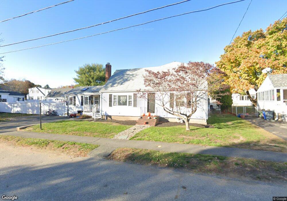
55 Proctor Cir Peabody, MA 01960
Estimated Value: $830,000 - $960,000
4
Beds
2
Baths
2,150
Sq Ft
$422/Sq Ft
Est. Value
About This Home
This home is located at 55 Proctor Cir, Peabody, MA 01960 and is currently estimated at $906,889, approximately $421 per square foot. 55 Proctor Cir is a home located in Essex County with nearby schools including Peabody Veterans Memorial High School and St John The Baptist School.
Ownership History
Date
Name
Owned For
Owner Type
Purchase Details
Closed on
Jul 31, 2019
Sold by
Russell Bernard G and Russell Lori A
Bought by
Russell Bernard G and Russell Loria A
Current Estimated Value
Purchase Details
Closed on
Dec 3, 2014
Sold by
55 Proctor Cir Peabody
Bought by
Trigilio Betsey T
Purchase Details
Closed on
May 24, 2005
Sold by
55 Proctor Cir Peabody
Bought by
Trigilio Betsey T
Purchase Details
Closed on
Jun 30, 2004
Sold by
Trigilio Betsey T
Bought by
55 Proctor Circle Rt
Create a Home Valuation Report for This Property
The Home Valuation Report is an in-depth analysis detailing your home's value as well as a comparison with similar homes in the area
Purchase History
| Date | Buyer | Sale Price | Title Company |
|---|---|---|---|
| Russell Bernard G | -- | -- | |
| Trigilio Betsey T | -- | -- | |
| Trigilio Betsey T | -- | -- | |
| 55 Proctor Circle Rt | -- | -- |
Source: Public Records
Mortgage History
| Date | Status | Borrower | Loan Amount |
|---|---|---|---|
| Previous Owner | 55 Proctor Circle Rt | $40,000 |
Source: Public Records
Tax History
| Year | Tax Paid | Tax Assessment Tax Assessment Total Assessment is a certain percentage of the fair market value that is determined by local assessors to be the total taxable value of land and additions on the property. | Land | Improvement |
|---|---|---|---|---|
| 2025 | $8,090 | $873,700 | $311,800 | $561,900 |
| 2024 | $7,597 | $833,000 | $311,800 | $521,200 |
| 2023 | $6,689 | $702,600 | $259,900 | $442,700 |
| 2022 | $6,627 | $656,100 | $226,000 | $430,100 |
| 2021 | $6,484 | $618,100 | $205,400 | $412,700 |
| 2020 | $6,606 | $615,100 | $205,400 | $409,700 |
| 2019 | $6,217 | $564,700 | $205,400 | $359,300 |
| 2018 | $5,943 | $518,600 | $183,400 | $335,200 |
| 2017 | $5,813 | $494,300 | $183,400 | $310,900 |
| 2016 | $4,487 | $376,400 | $183,400 | $193,000 |
| 2015 | -- | $358,000 | $183,400 | $174,600 |
Source: Public Records
Map
Nearby Homes
- 55 Hawthorne Cir
- 23 Tamarack Ln Unit 23
- 500 Northshore Rd Unit 6B
- 21 Forest St
- 4R Forest St
- 233 Lowell St Unit 1
- 4 Price Rd
- 38-1/2 Ellsworth Rd
- 158 Lowell St Unit 4
- 0 Buttonwood Ln Unit 2
- 14 Raylen Ave
- 11 Andover St
- 59 Nancy Ave
- 10 Crowninshield St Unit 303
- 8 Crowninshield St Unit 410
- 6 Rear Perkins St
- 152 Endicott St
- 111 Foster St Unit 416
- 98 Foster St
- 64 Foster St Unit 403
Your Personal Tour Guide
Ask me questions while you tour the home.