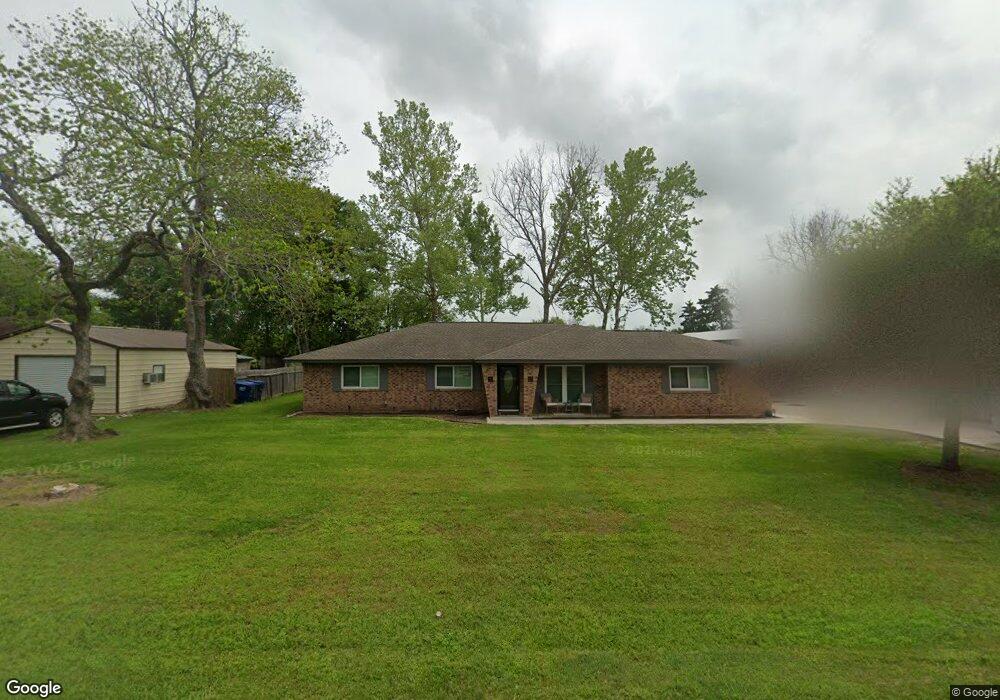
55 Red River Rd Bay City, TX 77414
Estimated Value: $222,000 - $288,000
4
Beds
2
Baths
1,895
Sq Ft
$129/Sq Ft
Est. Value
About This Home
This home is located at 55 Red River Rd, Bay City, TX 77414 and is currently estimated at $245,234, approximately $129 per square foot. 55 Red River Rd is a home located in Matagorda County with nearby schools including John H. Cherry Elementary School, Bay City Junior High School, and Bay City High School.
Ownership History
Date
Name
Owned For
Owner Type
Purchase Details
Closed on
Feb 25, 2008
Sold by
Hall Craig Mitchell and Hall Kellie
Bought by
Zepeda Sergio G and Zepeda Melinda
Current Estimated Value
Home Financials for this Owner
Home Financials are based on the most recent Mortgage that was taken out on this home.
Original Mortgage
$156,761
Outstanding Balance
$97,345
Interest Rate
5.68%
Mortgage Type
FHA
Estimated Equity
$147,889
Purchase Details
Closed on
Dec 5, 2006
Sold by
Lunsford Stephen L and Lunsford Lylie Ann
Bought by
Hall Craig Mitchell
Home Financials for this Owner
Home Financials are based on the most recent Mortgage that was taken out on this home.
Original Mortgage
$128,700
Interest Rate
6.41%
Mortgage Type
New Conventional
Create a Home Valuation Report for This Property
The Home Valuation Report is an in-depth analysis detailing your home's value as well as a comparison with similar homes in the area
Home Values in the Area
Average Home Value in this Area
Purchase History
| Date | Buyer | Sale Price | Title Company |
|---|---|---|---|
| Zepeda Sergio G | -- | -- | |
| Hall Craig Mitchell | -- | -- |
Source: Public Records
Mortgage History
| Date | Status | Borrower | Loan Amount |
|---|---|---|---|
| Open | Zepeda Sergio G | $156,761 | |
| Previous Owner | Hall Craig Mitchell | $128,700 |
Source: Public Records
Tax History Compared to Growth
Tax History
| Year | Tax Paid | Tax Assessment Tax Assessment Total Assessment is a certain percentage of the fair market value that is determined by local assessors to be the total taxable value of land and additions on the property. | Land | Improvement |
|---|---|---|---|---|
| 2024 | $44 | $260,230 | $48,380 | $211,850 |
| 2023 | $4,066 | $249,800 | $37,100 | $212,700 |
| 2022 | $4,537 | $227,190 | $17,780 | $209,410 |
| 2021 | $4,754 | $221,620 | $17,780 | $203,840 |
| 2020 | $4,613 | $195,510 | $17,780 | $177,730 |
| 2019 | $3,904 | $165,600 | $17,780 | $147,820 |
| 2018 | $3,749 | $167,390 | $17,780 | $149,610 |
| 2017 | $3,309 | $155,780 | $17,780 | $138,000 |
| 2016 | $3,197 | $150,510 | $17,780 | $132,730 |
| 2015 | -- | $144,350 | $17,780 | $126,570 |
| 2014 | -- | $152,140 | $17,780 | $134,360 |
Source: Public Records
Map
Nearby Homes
- 169 Timberline Dr
- 79 Lower Colorado Dr
- 202 County Road 402
- 710 Avenue F N
- 900 Avenue B
- 1103 Brasfield St
- 0 Hwy 60 N Unit 778292
- 0 Hwy 60 N Unit 16149622
- 1329 Adams Rd
- 0 7th St W Unit 778256
- 97 7th St
- 1100 Avenue C
- 1211 Avenue M
- 1908 Park
- 1313 Avenue F ( Highway 60)
- 910 7th St
- 1109 Avenue M
- 2200 Golden Ave
- 118 Cedar Vale Rd
- 2513 Avenue A