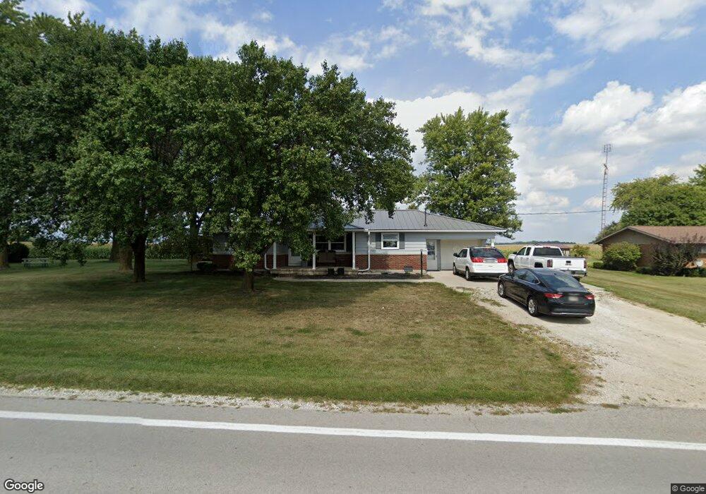
55 State Route 219 Fort Recovery, OH 45846
Estimated Value: $171,000 - $245,000
2
Beds
1
Bath
1,132
Sq Ft
$173/Sq Ft
Est. Value
About This Home
This home is located at 55 State Route 219, Fort Recovery, OH 45846 and is currently estimated at $196,333, approximately $173 per square foot. 55 State Route 219 is a home located in Mercer County with nearby schools including Coldwater Elementary School, Coldwater Middle School, and Coldwater High School.
Ownership History
Date
Name
Owned For
Owner Type
Purchase Details
Closed on
Mar 7, 2024
Sold by
Muhlenkamp Jacob S and Muhlenkamp Rachel A
Bought by
Muhlenkamp Samuel A and Hart Ashley T
Current Estimated Value
Home Financials for this Owner
Home Financials are based on the most recent Mortgage that was taken out on this home.
Original Mortgage
$102,654
Outstanding Balance
$100,947
Interest Rate
6.63%
Mortgage Type
New Conventional
Estimated Equity
$95,386
Purchase Details
Closed on
Aug 23, 2019
Sold by
Muhlenkamp Jacob S
Bought by
Muhlenkamp Jacob S and Muhlenkamp Rachel A
Purchase Details
Closed on
Jul 25, 2016
Sold by
Buening Carla J
Bought by
Muhlenkamp Jacob S
Home Financials for this Owner
Home Financials are based on the most recent Mortgage that was taken out on this home.
Original Mortgage
$403,504
Interest Rate
3.56%
Mortgage Type
Future Advance Clause Open End Mortgage
Create a Home Valuation Report for This Property
The Home Valuation Report is an in-depth analysis detailing your home's value as well as a comparison with similar homes in the area
Home Values in the Area
Average Home Value in this Area
Purchase History
| Date | Buyer | Sale Price | Title Company |
|---|---|---|---|
| Muhlenkamp Samuel A | $151,666 | Mattingly Ford Title Services | |
| Muhlenkamp Samuel A | $151,666 | Mattingly Ford Title Services | |
| Muhlenkamp Jacob S | -- | None Available | |
| Muhlenkamp Jacob S | $82,000 | Attorney |
Source: Public Records
Mortgage History
| Date | Status | Borrower | Loan Amount |
|---|---|---|---|
| Open | Muhlenkamp Samuel A | $102,654 | |
| Closed | Muhlenkamp Samuel A | $102,654 | |
| Previous Owner | Muhlenkamp Jacob S | $403,504 |
Source: Public Records
Tax History Compared to Growth
Tax History
| Year | Tax Paid | Tax Assessment Tax Assessment Total Assessment is a certain percentage of the fair market value that is determined by local assessors to be the total taxable value of land and additions on the property. | Land | Improvement |
|---|---|---|---|---|
| 2024 | $1,496 | $45,360 | $8,470 | $36,890 |
| 2023 | $1,496 | $45,360 | $8,470 | $36,890 |
| 2022 | $1,353 | $37,030 | $5,390 | $31,640 |
| 2021 | $1,351 | $37,030 | $5,390 | $31,640 |
| 2020 | $1,283 | $36,750 | $5,390 | $31,360 |
| 2019 | $1,191 | $32,100 | $4,900 | $27,200 |
| 2018 | $1,186 | $32,100 | $4,900 | $27,200 |
| 2017 | $989 | $32,100 | $4,900 | $27,200 |
| 2016 | $790 | $30,280 | $4,830 | $25,450 |
| 2015 | $763 | $30,280 | $4,830 | $25,450 |
| 2014 | $769 | $30,280 | $4,830 | $25,450 |
| 2013 | $763 | $28,040 | $4,480 | $23,560 |
Source: Public Records
Map
Nearby Homes
- 207 W Butler St
- 2332 State Route 29
- 6699 Gause Rd
- 1610 E Division Rd
- 912 Emerald Ave
- 821 Butler St
- 820 Mary Ln
- 1096 E 26 Hwy
- 420 S 1st St
- 501 N 2nd St
- 207 Walnut St Unit Bryant
- 207 Walnut St
- 311 E Main St
- 309 E Vine St
- 402 E Elizabeth St
- 408 E Main St
- 320 E North St
- TBD E High St
- 0 Anderson Lots 10 11 & 12 Ln Unit 1037885
- 0 Springer 1-6 & Roadway 14-16 Unit 1037883
- 67 State Route 219
- 43 Ohio 219 Unit 43
- 43 State Route 219
- 77 State Route 219
- 3 Ohio 219
- 4 Ohio 219
- 3158 N State Line Rd
- 4762 Ohio Indiana State Line Rd
- 4780 Ohio Indiana State Line Rd
- 182 State Route 219
- 2644 N State Line Rd
- 319 State Route 219
- 8811 E 300 N
- 8812 E 300 N
- 427 State Route 219
- 8631 E 300 N
- 2158 N State Line Rd
- 4635 State Route 49
- 3025 N 850 E
- 3026 N 850 E