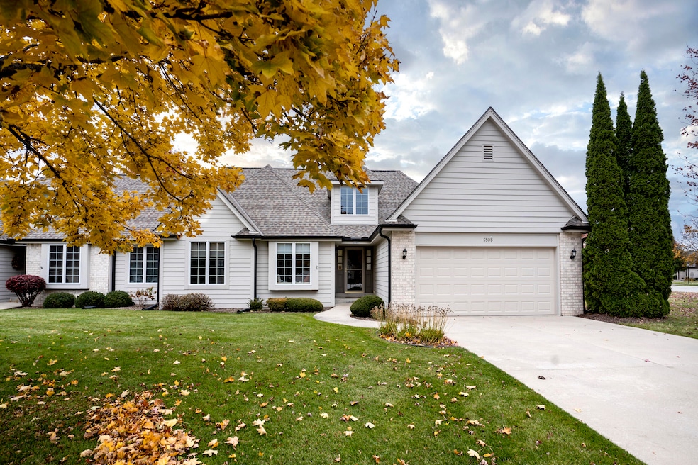
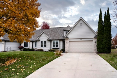
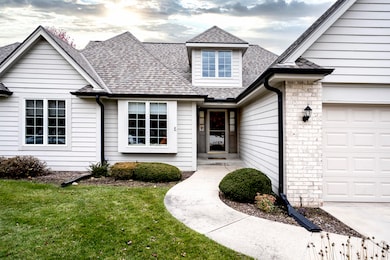
550 McPride Ln Unit B Brookfield, WI 53045
Estimated payment $2,759/month
Highlights
- Popular Property
- 2 Car Attached Garage
- Water Softener is Owned
- No HOA
- 1-Story Property
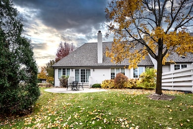
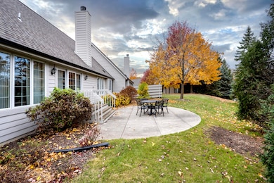
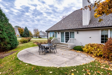
About This Home
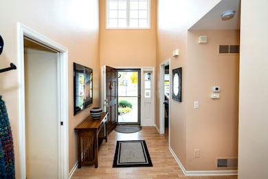
Gorgeous side-by-side condo in Pheasant Run. Bright, sunny with beautiful updates. Corian countertops, wood floor laminates and newer painting throughout. Vaulted ceiling entryway with plenty of light! Dry, unfinished lower level. Quarterly association fees $2,082. Gorgeous master suite with WIC and deluxe bathroom--separate tub and SS. Gas fireplace and stone hearth. Unfinished, dry 8' ceiling basement with backup battery for sump pump. Ceiling fans in master and living room. Fees cover beautiful landscaping, snow removal, water, and sewer. Beautiful complex--close to Brookfield shopping, parks, churches, library.

Property Details
Home Type
- Condominium
Est. Annual Taxes
- $4,067
Parking
- 2 Car Attached Garage
Home Design
- Brick Exterior Construction
- Poured Concrete
Interior Spaces
- 1,727 Sq Ft Home
- 1-Story Property
Kitchen
- Oven
- Cooktop
- Microwave
- Dishwasher
- Disposal
Bedrooms and Bathrooms
- 3 Bedrooms
- 2 Full Bathrooms
Laundry
- Dryer
- Washer
Basement
- Basement Fills Entire Space Under The House
- Basement Ceilings are 8 Feet High
- Sump Pump
Utilities
- Water Softener is Owned
Community Details
- No Home Owners Association
- Association fees include lawn maintenance, snow removal, water, sewer, trash, replacement reserve, common area insur
Listing and Financial Details
- Exclusions: Seller's personal property.
- Assessor Parcel Number BRC1133162
Map
Home Values in the Area
Average Home Value in this Area
Tax History
| Year | Tax Paid | Tax Assessment Tax Assessment Total Assessment is a certain percentage of the fair market value that is determined by local assessors to be the total taxable value of land and additions on the property. | Land | Improvement |
|---|---|---|---|---|
| 2024 | $4,067 | $410,500 | $100,000 | $310,500 |
| 2023 | $4,060 | $410,500 | $100,000 | $310,500 |
| 2022 | $4,114 | $309,100 | $90,000 | $219,100 |
| 2021 | $4,159 | $309,100 | $90,000 | $219,100 |
| 2020 | $4,276 | $309,100 | $90,000 | $219,100 |
| 2019 | $4,198 | $309,100 | $90,000 | $219,100 |
| 2018 | $3,814 | $280,300 | $70,000 | $210,300 |
| 2017 | $4,519 | $280,300 | $70,000 | $210,300 |
| 2016 | $4,101 | $280,300 | $70,000 | $210,300 |
| 2015 | $3,905 | $280,300 | $70,000 | $210,300 |
| 2014 | $4,237 | $280,300 | $70,000 | $210,300 |
| 2013 | $4,237 | $280,300 | $70,000 | $210,300 |
Property History
| Date | Event | Price | List to Sale | Price per Sq Ft |
|---|---|---|---|---|
| 11/12/2025 11/12/25 | For Sale | $459,000 | -- | $266 / Sq Ft |
Purchase History
| Date | Type | Sale Price | Title Company |
|---|---|---|---|
| Deed | -- | Knight Barry Title | |
| Interfamily Deed Transfer | -- | None Available | |
| Condominium Deed | $235,500 | -- |
Mortgage History
| Date | Status | Loan Amount | Loan Type |
|---|---|---|---|
| Open | $273,250 | New Conventional | |
| Previous Owner | $188,400 | No Value Available |
Source: Metro MLS
MLS Number: 1942655
APN: 0BRC-1133-162
Disclaimer: Certain information contained herein is derived from information provided by parties other than Homes.com. All information provided is deemed reliable, but is not guaranteed to be accurate and should be independently verified.
![]() IDX information is provided exclusively for personal, non-commercial use, and may not be used for any purpose other than to identify prospective properties consumers may be interested in purchasing.
IDX information is provided exclusively for personal, non-commercial use, and may not be used for any purpose other than to identify prospective properties consumers may be interested in purchasing.
IDX listing data provided by Multiple Listing Service, Inc. Information is supplied by seller and other third parties and has not been verified.
Copyright 2025 – Multiple Listing Service, Inc. – All Rights Reserved.
- 19125 Hi View Dr Unit 125
- Lt1 Davidson Rd
- 19770 Foxkirk Ct
- 655 Mac Henry Cir Unit B
- 18740 Emerald Cir Unit E
- 18520 Emerald Cir Unit C
- 18520 Emerald Cir Unit F
- 18625 Emerald Cir Unit G
- 18425 Emerald Dr Unit G
- 18785 Davidson Rd
- 675 Charleston Ct Unit B
- 165 Aerie Cir Unit 105
- 165 Aerie Cir Unit 102
- 1405 S Westwoods Rd
- 18710 Follett Dr Unit 502
- 18290 Prairie Falcon Ln
- 18275 Brookfield Lake Dr Unit 93
- 18575 Brookfield Lake Dr Unit 61
- 745 Hi Ridge Ave
- 1080 Westbrooke Pkwy
- 19110 Emerald Dr Unit 20
- 201 S Brookfield Rd
- 325 N Brookfield Rd
- 260 Lord St
- 20315 E Sutter Creek Dr
- 625 Shepherd Ct
- 20200 Poplar Creek Pkwy
- 20825 George Hunt Cir
- 665 N Brookfield Rd
- 790 Lakeview Dr
- 2520 Plaza Ct
- 20245 Independence Dr Unit B
- 2420 Parklawn Dr
- 20245 Independence Dr
- 2415 Springdale Rd
- 2400 Springdale Rd
- 1455 N Brookfield Rd
- S15W22149 Overlook Ct
- 2408 Springdale Rd Unit ID1296537P
- 2421 Saratoga Rd Unit ID1296515P