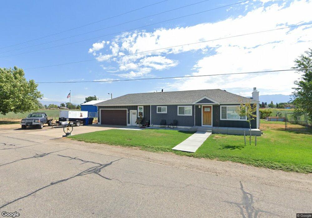
550 N 4000 W West Point, UT 84015
Estimated Value: $415,000 - $428,485
2
Beds
1
Bath
1,356
Sq Ft
$309/Sq Ft
Est. Value
About This Home
This home is located at 550 N 4000 W, West Point, UT 84015 and is currently estimated at $418,621, approximately $308 per square foot. 550 N 4000 W is a home located in Davis County with nearby schools including West Point School, West Point Junior High School, and Syracuse High School.
Ownership History
Date
Name
Owned For
Owner Type
Purchase Details
Closed on
Aug 25, 2016
Sold by
Munsell Cathy and Munsell David S
Bought by
Munsell David S
Current Estimated Value
Purchase Details
Closed on
Aug 24, 2016
Sold by
Munsell David S
Bought by
Manning Gary E and Manning Family Trust
Purchase Details
Closed on
Jan 30, 2012
Sold by
Manning Elmer F and Manning Velma T
Bought by
Manning Family Trust and Manning Velma T
Create a Home Valuation Report for This Property
The Home Valuation Report is an in-depth analysis detailing your home's value as well as a comparison with similar homes in the area
Home Values in the Area
Average Home Value in this Area
Purchase History
| Date | Buyer | Sale Price | Title Company |
|---|---|---|---|
| Munsell David S | -- | Security Title | |
| Manning Gary E | -- | Security Title | |
| Manning Family Trust | -- | None Available |
Source: Public Records
Tax History Compared to Growth
Tax History
| Year | Tax Paid | Tax Assessment Tax Assessment Total Assessment is a certain percentage of the fair market value that is determined by local assessors to be the total taxable value of land and additions on the property. | Land | Improvement |
|---|---|---|---|---|
| 2025 | $2,301 | $215,600 | $139,167 | $76,433 |
| 2024 | $2,150 | $202,399 | $125,142 | $77,257 |
| 2023 | $1,987 | $189,200 | $90,874 | $98,325 |
| 2022 | $2,124 | $366,000 | $161,160 | $204,840 |
| 2021 | $2,081 | $295,000 | $128,291 | $166,709 |
| 2020 | $1,837 | $257,000 | $109,581 | $147,419 |
| 2019 | $1,754 | $242,000 | $105,773 | $136,227 |
| 2018 | $1,588 | $216,000 | $101,872 | $114,128 |
| 2016 | $1,402 | $100,320 | $39,585 | $60,735 |
| 2015 | $1,398 | $94,765 | $39,585 | $55,180 |
| 2014 | $1,438 | $98,895 | $39,585 | $59,310 |
| 2013 | -- | $71,548 | $32,825 | $38,723 |
Source: Public Records
Map
Nearby Homes
- 357 N 4000 W
- 3932 W 825 N Unit WF5
- 3918 W 825 N Unit WF6
- Charleston Plan at Bluff View
- 4352 W 300 N
- 4469 W 1000 N Unit 120
- 114 3830 W
- 4366 W 200 N
- 120 N 4325 W
- 477 N 4500 W
- 4362 West St Unit 106
- 4358 West St Unit 105
- 399 N 3425 W
- 4325 W 75 N
- 9 S 3830 W Unit 441
- 27 S 3830 W Unit 437
- 28 S 3830 W Unit 424
- 3851 W 50 S Unit 425
- 3847 W 50 S Unit 428
- 3849 W 50 S Unit 426