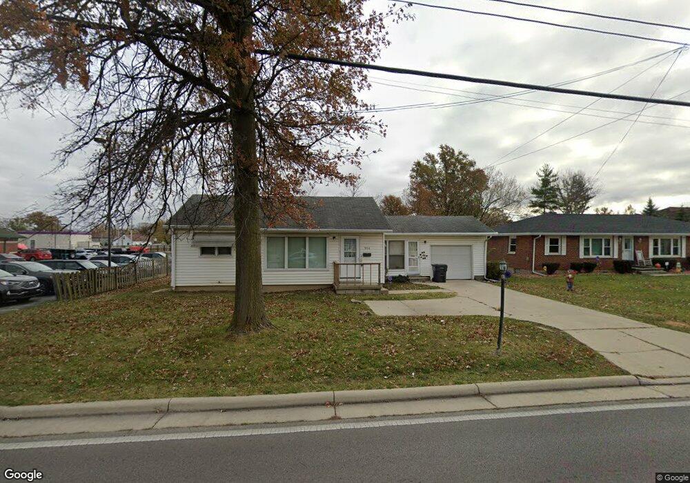
550 N Cable Rd Lima, OH 45805
Westgate NeighborhoodEstimated Value: $85,000 - $134,000
2
Beds
1
Bath
832
Sq Ft
$127/Sq Ft
Est. Value
About This Home
This home is located at 550 N Cable Rd, Lima, OH 45805 and is currently estimated at $105,774, approximately $127 per square foot. 550 N Cable Rd is a home located in Allen County with nearby schools including Heritage Elementary School, Lima West Middle School, and Lima North Middle School.
Ownership History
Date
Name
Owned For
Owner Type
Purchase Details
Closed on
Jan 30, 2026
Sold by
Wainscott Patrick J and Wainscott Lois M
Bought by
Wainscott Darren R
Current Estimated Value
Purchase Details
Closed on
Aug 28, 2021
Sold by
Bell William and Bell Jean A
Bought by
Wainscott Darren R
Purchase Details
Closed on
Aug 17, 2012
Sold by
Bell William and Bell Jean B
Bought by
Wainscott Patrick J
Purchase Details
Closed on
Oct 22, 2007
Sold by
Mckinley Rita F
Bought by
Bell William and Bell Jean A
Purchase Details
Closed on
Jan 1, 1990
Bought by
Davis Helen W
Create a Home Valuation Report for This Property
The Home Valuation Report is an in-depth analysis detailing your home's value as well as a comparison with similar homes in the area
Home Values in the Area
Average Home Value in this Area
Purchase History
| Date | Buyer | Sale Price | Title Company |
|---|---|---|---|
| Wainscott Darren R | -- | None Listed On Document | |
| Wainscott Darren R | $57,500 | None Available | |
| Wainscott Patrick J | $50,500 | None Available | |
| Bell William | $57,000 | None Available | |
| Davis Helen W | -- | -- |
Source: Public Records
Mortgage History
| Date | Status | Borrower | Loan Amount |
|---|---|---|---|
| Closed | Wainscott Patrick J | $0 |
Source: Public Records
Tax History
| Year | Tax Paid | Tax Assessment Tax Assessment Total Assessment is a certain percentage of the fair market value that is determined by local assessors to be the total taxable value of land and additions on the property. | Land | Improvement |
|---|---|---|---|---|
| 2024 | $1,072 | $28,460 | $9,210 | $19,250 |
| 2023 | $957 | $21,880 | $7,070 | $14,810 |
| 2022 | $962 | $21,880 | $7,070 | $14,810 |
| 2021 | $1,016 | $21,880 | $7,070 | $14,810 |
| 2020 | $953 | $18,130 | $6,230 | $11,900 |
| 2019 | $953 | $18,130 | $6,230 | $11,900 |
| 2018 | $931 | $18,130 | $6,230 | $11,900 |
| 2017 | $928 | $17,540 | $6,230 | $11,310 |
| 2016 | $935 | $17,540 | $6,230 | $11,310 |
| 2015 | $926 | $17,540 | $6,230 | $11,310 |
| 2014 | $926 | $17,650 | $6,200 | $11,450 |
| 2013 | $901 | $17,650 | $6,200 | $11,450 |
Source: Public Records
Map
Nearby Homes
- 705 Cornell Dr
- 3 Poulston Place
- 1753 Leland Ave
- 1918 Oakland Pkwy
- 1834 Latham Ave
- 926 Crestwood Dr
- 1605 Hazel Ave
- 541 N Nixon Ave
- 1607 W Wayne St
- 1600 Leland Ave
- 2425 Windsor Dr
- 2530 Windsor Dr
- 1817 Hillcrest Dr
- 100 Burlington Place
- 102 Charwood Dr
- 1517 Allentown Rd
- 1508 Oakland Pkwy
- 1440 W Market St
- 37 Beaumont Place
- 1453 W Market St
Your Personal Tour Guide
Ask me questions while you tour the home.