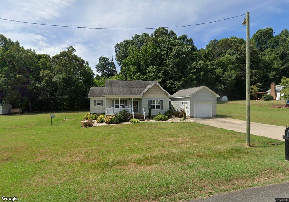
550 Ridge Ave Liberty, NC 27298
Estimated Value: $268,000 - $293,000
--
Bed
2
Baths
1,456
Sq Ft
$190/Sq Ft
Est. Value
About This Home
This home is located at 550 Ridge Ave, Liberty, NC 27298 and is currently estimated at $276,427, approximately $189 per square foot. 550 Ridge Ave is a home located in Randolph County with nearby schools including Liberty Elementary School, Northeastern Randolph Middle School, and Providence Grove High School.
Ownership History
Date
Name
Owned For
Owner Type
Purchase Details
Closed on
Aug 24, 2009
Sold by
Phil Burgess Construction Inc
Bought by
Shoffner Terra B
Current Estimated Value
Home Financials for this Owner
Home Financials are based on the most recent Mortgage that was taken out on this home.
Original Mortgage
$158,000
Outstanding Balance
$112,002
Interest Rate
5.19%
Mortgage Type
Purchase Money Mortgage
Estimated Equity
$164,425
Create a Home Valuation Report for This Property
The Home Valuation Report is an in-depth analysis detailing your home's value as well as a comparison with similar homes in the area
Home Values in the Area
Average Home Value in this Area
Purchase History
| Date | Buyer | Sale Price | Title Company |
|---|---|---|---|
| Shoffner Terra B | $158,000 | None Available |
Source: Public Records
Mortgage History
| Date | Status | Borrower | Loan Amount |
|---|---|---|---|
| Open | Shoffner Terra B | $158,000 |
Source: Public Records
Tax History Compared to Growth
Tax History
| Year | Tax Paid | Tax Assessment Tax Assessment Total Assessment is a certain percentage of the fair market value that is determined by local assessors to be the total taxable value of land and additions on the property. | Land | Improvement |
|---|---|---|---|---|
| 2025 | $2,967 | $243,170 | $59,410 | $183,760 |
| 2024 | $2,772 | $243,170 | $59,410 | $183,760 |
| 2023 | $2,553 | $243,170 | $59,410 | $183,760 |
| 2022 | $1,753 | $137,760 | $15,530 | $122,230 |
| 2021 | $1,753 | $137,760 | $15,530 | $122,230 |
| 2020 | $1,751 | $137,550 | $15,320 | $122,230 |
| 2019 | $1,751 | $137,550 | $15,320 | $122,230 |
| 2018 | $1,689 | $130,650 | $15,320 | $115,330 |
| 2016 | $1,558 | $130,645 | $15,320 | $115,325 |
| 2015 | $1,561 | $130,645 | $15,320 | $115,325 |
| 2014 | $1,561 | $130,645 | $15,320 | $115,325 |
Source: Public Records
Map
Nearby Homes
- 530 E Raleigh Ave
- 318 S Fayetteville St
- 132 W Kime Ave
- 328 E Raleigh Ave
- 212 S Fayetteville St
- 334 E Swannanoa Ave
- 634 E Swannanoa Ave
- 243 W Brower Ave
- 0 Crutchfield Country Rd
- 111 W Starmount Ave
- 543 Beaver Dam Rd
- 324 W Starmount Ave
- 503 Beaver Dam Rd
- 0 W Swannanoa Ave
- 228 Pickett Cir
- 540 N Timberlea St
- 503 N Greenbriar St
- 7182 Nc Highway 49 N
- 200 New St
- 210 S Carter St
- 553 E Ridge Ave
- 540 E Ridge Ave
- 545 E Ridge Ave
- 552 E Ridge Ave
- 00 E Ridge Ave
- 0 E Ridge Ave Unit 1856642
- 0 E Ridge Ave Unit 1856637
- 0 E Ridge Ave Unit 4 TR1856637
- 0 E Ridge Ave Unit 5 1856642
- 552 Ridge Ave
- 532 Ridge Ave
- 555 Ridge Ave
- 557 E Ridge Ave
- 558 Ridge Ave
- 524 Ridge Ave
- 625 S Valley St
- 611 S Valley St
- 574 E Ridge Ave
- 565 E Ridge Ave
- 559 E Ridge Ave