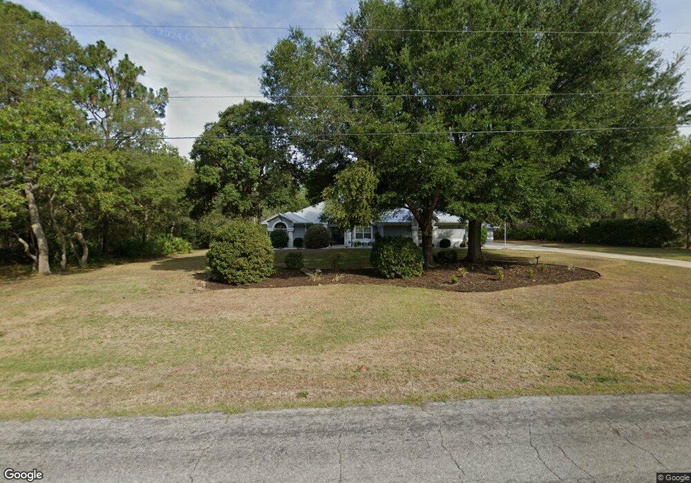
5502 N Bedstrow Blvd Beverly Hills, FL 34465
Estimated Value: $476,000 - $507,000
3
Beds
4
Baths
2,384
Sq Ft
$207/Sq Ft
Est. Value
About This Home
This home is located at 5502 N Bedstrow Blvd, Beverly Hills, FL 34465 and is currently estimated at $494,253, approximately $207 per square foot. 5502 N Bedstrow Blvd is a home located in Citrus County with nearby schools including Central Ridge Elementary School, Citrus Springs Middle School, and Lecanto High School.
Ownership History
Date
Name
Owned For
Owner Type
Purchase Details
Closed on
Oct 1, 1999
Bought by
Creech Charles Richard
Current Estimated Value
Purchase Details
Closed on
Jun 1, 1999
Bought by
Creech Charles Richard
Purchase Details
Closed on
Apr 1, 1998
Bought by
Creech Charles Richard
Purchase Details
Closed on
Jan 1, 1991
Bought by
Creech Charles Richard
Purchase Details
Closed on
May 1, 1987
Bought by
Creech Charles Richard
Create a Home Valuation Report for This Property
The Home Valuation Report is an in-depth analysis detailing your home's value as well as a comparison with similar homes in the area
Home Values in the Area
Average Home Value in this Area
Purchase History
| Date | Buyer | Sale Price | Title Company |
|---|---|---|---|
| Creech Charles Richard | $11,500 | -- | |
| Creech Charles Richard | $10,000 | -- | |
| Creech Charles Richard | $2,000 | -- | |
| Creech Charles Richard | $21,200 | -- | |
| Creech Charles Richard | $7,304,100 | -- |
Source: Public Records
Tax History Compared to Growth
Tax History
| Year | Tax Paid | Tax Assessment Tax Assessment Total Assessment is a certain percentage of the fair market value that is determined by local assessors to be the total taxable value of land and additions on the property. | Land | Improvement |
|---|---|---|---|---|
| 2024 | $2,763 | $218,050 | -- | -- |
| 2023 | $2,763 | $211,699 | $0 | $0 |
| 2022 | $2,588 | $205,533 | $0 | $0 |
| 2021 | $2,485 | $199,547 | $0 | $0 |
| 2020 | $2,386 | $256,929 | $17,190 | $239,739 |
| 2019 | $2,356 | $243,588 | $16,920 | $226,668 |
| 2018 | $2,323 | $220,160 | $14,500 | $205,660 |
| 2017 | $2,281 | $182,097 | $16,060 | $166,037 |
| 2016 | $2,310 | $178,352 | $14,060 | $164,292 |
| 2015 | $2,345 | $177,112 | $13,240 | $163,872 |
| 2014 | $2,397 | $175,706 | $15,948 | $159,758 |
Source: Public Records
Map
Nearby Homes
- 5361 N Peppermint Dr
- 2210 W La Bonte Cir
- 1425 W Pinehill Dr
- 6686 N Bedstrow Blvd
- 5626 N Bedstrow Blvd
- 1373 W Pinehill Dr
- 1993 W Learwood Place
- 5063 N Peppermint Dr
- 5839 N Maroon Way
- 1234 W Sphere Place
- 5596 N Lamp Post Dr
- 5064 N Peppermint Dr
- 5326 N Red Ribbon Point
- 5862 N Summerfield Point
- 5386 N Lena Dr
- 5566 N Princewood Dr
- 5755 N Summerfield Point
- 1282 W Hampshire Blvd
- 6098 N Peardale Terrace
- 1888 W Mc Neal Dr
- 5534 N Bedstrow Blvd Unit 3
- 5474 5474 N Bedstrow Blvd
- 5569 N Nakoma Dr
- 5547 N Nakoma Dr
- 5580 N Oakmont Dr
- 5426 N Bedstrow Blvd
- 5479 N Nakoma Dr
- 5441 N Bedstrow Blvd
- 5545 N Bedstrow Blvd
- 5405 N Bedstrow Blvd
- 5552 N Nakoma Dr
- 5398 N Bedstrow Blvd
- 5584 N Nakoma Dr
- 5408 N Peppermint Dr
- 5538 N Nakoma Dr
- 5440 N Peppermint Dr
- 5595 N Oakmont Dr
- 5655 N Nakoma Dr
- 5373 N Bedstrow Blvd
- 5436 N Nakoma Dr