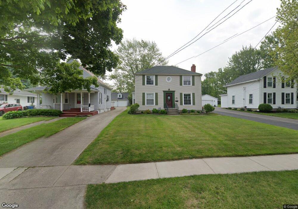
551 East St Amherst, OH 44001
Estimated Value: $216,000 - $239,000
4
Beds
2
Baths
1,643
Sq Ft
$139/Sq Ft
Est. Value
About This Home
This home is located at 551 East St, Amherst, OH 44001 and is currently estimated at $227,998, approximately $138 per square foot. 551 East St is a home located in Lorain County with nearby schools including Powers Elementary School, Walter G. Nord Middle School, and Amherst Junior High School.
Ownership History
Date
Name
Owned For
Owner Type
Purchase Details
Closed on
Mar 15, 2024
Sold by
Brotzki Mary P and Brotzki Daniel J
Bought by
Brotzki Daniel J
Current Estimated Value
Purchase Details
Closed on
Dec 24, 1999
Sold by
Glen Wilburn and Glen Justine A
Bought by
Brotzki Daniel J and Brotzki Mary P
Home Financials for this Owner
Home Financials are based on the most recent Mortgage that was taken out on this home.
Original Mortgage
$116,500
Interest Rate
7.7%
Purchase Details
Closed on
Sep 22, 1995
Sold by
Love Martha J
Bought by
Wilburn Glen and Wilburn Justine A
Home Financials for this Owner
Home Financials are based on the most recent Mortgage that was taken out on this home.
Original Mortgage
$77,000
Interest Rate
7.78%
Mortgage Type
New Conventional
Create a Home Valuation Report for This Property
The Home Valuation Report is an in-depth analysis detailing your home's value as well as a comparison with similar homes in the area
Home Values in the Area
Average Home Value in this Area
Purchase History
| Date | Buyer | Sale Price | Title Company |
|---|---|---|---|
| Brotzki Daniel J | -- | None Listed On Document | |
| Brotzki Daniel J | $144,500 | Midland Title | |
| Wilburn Glen | $97,600 | -- |
Source: Public Records
Mortgage History
| Date | Status | Borrower | Loan Amount |
|---|---|---|---|
| Previous Owner | Brotzki Daniel J | $116,500 | |
| Previous Owner | Wilburn Glen | $77,000 |
Source: Public Records
Tax History Compared to Growth
Tax History
| Year | Tax Paid | Tax Assessment Tax Assessment Total Assessment is a certain percentage of the fair market value that is determined by local assessors to be the total taxable value of land and additions on the property. | Land | Improvement |
|---|---|---|---|---|
| 2024 | $2,602 | $64,439 | $11,302 | $53,137 |
| 2023 | $2,633 | $54,954 | $10,584 | $44,370 |
| 2022 | $2,524 | $54,954 | $10,584 | $44,370 |
| 2021 | $2,530 | $54,954 | $10,584 | $44,370 |
| 2020 | $2,418 | $46,610 | $8,980 | $37,630 |
| 2019 | $2,370 | $46,610 | $8,980 | $37,630 |
| 2018 | $2,441 | $46,610 | $8,980 | $37,630 |
| 2017 | $2,500 | $45,920 | $7,610 | $38,310 |
| 2016 | $2,520 | $45,920 | $7,610 | $38,310 |
| 2015 | $2,506 | $45,920 | $7,610 | $38,310 |
| 2014 | $2,309 | $42,120 | $6,980 | $35,140 |
| 2013 | $2,317 | $42,120 | $6,980 | $35,140 |
Source: Public Records
Map
Nearby Homes
- 2176 Myla Way
- 2180 Myla Way
- 653 Brennan Dr
- 891 Park Ave
- V/L Middle Ridge Rd
- 275 Cornell Ave
- 168 Orchard Hill Dr
- 1140 Woodside Dr
- 328 Buttermere Ln Unit 328
- 0 Middle Ridge Rd Unit 5160578
- 0 Middle Ridge Rd Unit 5102632
- 281 English Lakes Blvd Unit 67281
- 133 Ambleside Way
- 825 Cleveland Ave
- 923 Longitude Ln
- 812 Bearing Ct
- 650 Eastpointe Ct
- 621 Van Oaks Dr
- 394 Long St
- 483 N Main St