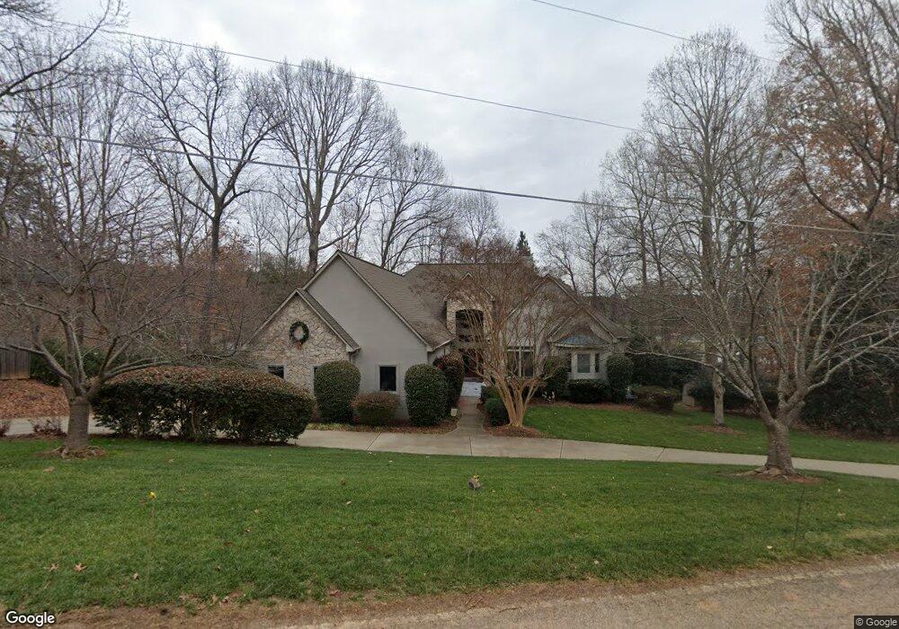
551 Kenway Loop Mooresville, NC 28117
Estimated Value: $1,393,000 - $1,879,217
4
Beds
4
Baths
3,418
Sq Ft
$467/Sq Ft
Est. Value
About This Home
This home is located at 551 Kenway Loop, Mooresville, NC 28117 and is currently estimated at $1,596,554, approximately $467 per square foot. 551 Kenway Loop is a home located in Iredell County with nearby schools including Lakeshore Elementary School, Lakeshore Middle School, and Lake Norman High School.
Ownership History
Date
Name
Owned For
Owner Type
Purchase Details
Closed on
Mar 19, 1999
Sold by
Drew Yatsko Mitchell
Bought by
Humm Andrew S and Humm Rebecca
Current Estimated Value
Home Financials for this Owner
Home Financials are based on the most recent Mortgage that was taken out on this home.
Original Mortgage
$111,807
Interest Rate
6.74%
Purchase Details
Closed on
Aug 1, 1997
Purchase Details
Closed on
Jun 1, 1977
Create a Home Valuation Report for This Property
The Home Valuation Report is an in-depth analysis detailing your home's value as well as a comparison with similar homes in the area
Home Values in the Area
Average Home Value in this Area
Purchase History
| Date | Buyer | Sale Price | Title Company |
|---|---|---|---|
| Humm Andrew S | $123,000 | -- | |
| -- | $105,000 | -- | |
| -- | -- | -- |
Source: Public Records
Mortgage History
| Date | Status | Borrower | Loan Amount |
|---|---|---|---|
| Closed | Humm Andrew S | $111,807 |
Source: Public Records
Tax History Compared to Growth
Tax History
| Year | Tax Paid | Tax Assessment Tax Assessment Total Assessment is a certain percentage of the fair market value that is determined by local assessors to be the total taxable value of land and additions on the property. | Land | Improvement |
|---|---|---|---|---|
| 2024 | $8,224 | $1,360,660 | $375,000 | $985,660 |
| 2023 | $8,224 | $1,360,660 | $375,000 | $985,660 |
| 2022 | $5,539 | $859,510 | $227,500 | $632,010 |
| 2021 | $5,449 | $859,510 | $227,500 | $632,010 |
| 2020 | $5,449 | $859,510 | $227,500 | $632,010 |
| 2019 | $5,235 | $859,510 | $227,500 | $632,010 |
| 2018 | $4,506 | $745,450 | $227,500 | $517,950 |
| 2017 | $4,506 | $745,450 | $227,500 | $517,950 |
| 2016 | $4,506 | $745,450 | $227,500 | $517,950 |
| 2015 | $4,506 | $745,450 | $227,500 | $517,950 |
| 2014 | $4,616 | $808,010 | $260,000 | $548,010 |
Source: Public Records
Map
Nearby Homes
- 496 Kenway Loop
- 512 Kenway Loop
- 676 Kenway Loop
- 669 Kenway Loop
- 394 Kenway Loop
- 372 Kenway Loop
- 182 Broadview Cir
- 168 Blue Ridge Trail
- 329 Stumpy Creek Rd
- 117 Wolf Hill Dr
- 220 Kenway Loop
- 129 Sleepy Cove Trail Unit 5
- 181 Kiskadee Dr Unit 14
- 199 Kenway Loop
- 152 Bay Shore Loop
- 214 Wildwood Cove Dr
- 156 Bay Shore Loop
- 107 Kenway Loop
- 152 Fox Hunt Dr
- 787 Morrison Farm Rd
- 557 Kenway Loop
- 543 Kenway Loop
- 565 Kenway Loop
- 554 Kenway Loop
- 554 Kenway Loop Unit 6
- 558 Kenway Loop
- 558 Kenway Loop Unit 7
- 550 Kenway Loop
- 550 Kenway Loop Unit 5
- 564 Kenway Loop
- 564 Kenway Loop Unit 8
- 481 Kenway Loop
- 0000 Kenway Loop
- 489 Kenway Loop
- 546 Kenway Loop
- 546 Kenway Loop Unit 4
- 568 Kenway Loop
- 571 Kenway Loop
- 540 Kenway Loop Unit 3
- 471 Kenway Loop