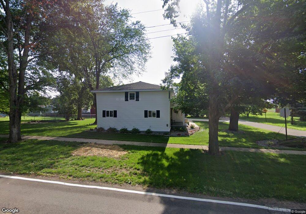
551 S Maple Ave Maple Rapids, MI 48853
Estimated Value: $153,975 - $177,000
3
Beds
1
Bath
1,280
Sq Ft
$129/Sq Ft
Est. Value
About This Home
This home is located at 551 S Maple Ave, Maple Rapids, MI 48853 and is currently estimated at $164,744, approximately $128 per square foot. 551 S Maple Ave is a home located in Clinton County with nearby schools including Fulton Elementary School, Fulton Middle School, and Fulton High School.
Ownership History
Date
Name
Owned For
Owner Type
Purchase Details
Closed on
Nov 21, 2013
Sold by
Blemaster Bradley J and Blemaster Pamela K
Bought by
Max E Slagel & Mary E Slager Living Trus
Current Estimated Value
Purchase Details
Closed on
Sep 25, 2009
Sold by
Hsbc Mortgage Services Inc
Bought by
Blemaster Bradley J and Blemaster Pamela K
Purchase Details
Closed on
Sep 20, 2007
Sold by
Lofton Heather and Hansen Robert W
Bought by
Hsbc Mortgage Services Inc
Purchase Details
Closed on
Sep 24, 2004
Sold by
Abshagen Gary and Abshagen Jason W
Bought by
Lofton Heather and Hansen Robert
Home Financials for this Owner
Home Financials are based on the most recent Mortgage that was taken out on this home.
Original Mortgage
$66,224
Interest Rate
10.37%
Mortgage Type
New Conventional
Create a Home Valuation Report for This Property
The Home Valuation Report is an in-depth analysis detailing your home's value as well as a comparison with similar homes in the area
Purchase History
| Date | Buyer | Sale Price | Title Company |
|---|---|---|---|
| Max E Slagel & Mary E Slager Living Trus | $83,026 | None Available | |
| Blemaster Bradley J | $19,000 | Tri County Title | |
| Hsbc Mortgage Services Inc | $44,420 | None Available | |
| Lofton Heather | $82,780 | -- |
Source: Public Records
Mortgage History
| Date | Status | Borrower | Loan Amount |
|---|---|---|---|
| Previous Owner | Lofton Heather | $66,224 |
Source: Public Records
Tax History
| Year | Tax Paid | Tax Assessment Tax Assessment Total Assessment is a certain percentage of the fair market value that is determined by local assessors to be the total taxable value of land and additions on the property. | Land | Improvement |
|---|---|---|---|---|
| 2025 | $754 | $67,400 | $11,000 | $56,400 |
| 2024 | $4 | $60,400 | $10,000 | $50,400 |
| 2023 | $338 | $56,500 | $0 | $0 |
| 2022 | $701 | $52,000 | $9,100 | $42,900 |
| 2021 | $683 | $46,000 | $8,800 | $37,200 |
| 2020 | $596 | $42,700 | $8,400 | $34,300 |
| 2019 | $561 | $37,300 | $8,400 | $28,900 |
| 2018 | $547 | $35,700 | $8,400 | $27,300 |
| 2017 | -- | $37,900 | $8,400 | $29,500 |
| 2016 | $531 | $36,000 | $8,400 | $27,600 |
| 2015 | -- | $32,000 | $0 | $0 |
| 2011 | -- | $28,400 | $0 | $0 |
Source: Public Records
Map
Nearby Homes
- 132 E Washington St
- 129 E Main St
- 220 N Maple Ave
- TBD E Main St
- 7240 Empire Rd
- 8150 Idared Rd
- 8095 Mcintosh Rd
- 9515 W Moss Rd
- 7150 W Mead Rd
- 00 S Skyline
- 4941 Skyline Dr
- 005 Skyline Dr
- 159 Hardwood Trail
- TBD Hardwood Trail
- TBD Oakridge Trail
- Lot 355 Oakridge Trail
- 04 Lakeview Ct
- 05 Lakeview Ct
- 00 W Ranger Rd
- 0 Lakeside Dr Unit LOT 1 3520630
Your Personal Tour Guide
Ask me questions while you tour the home.