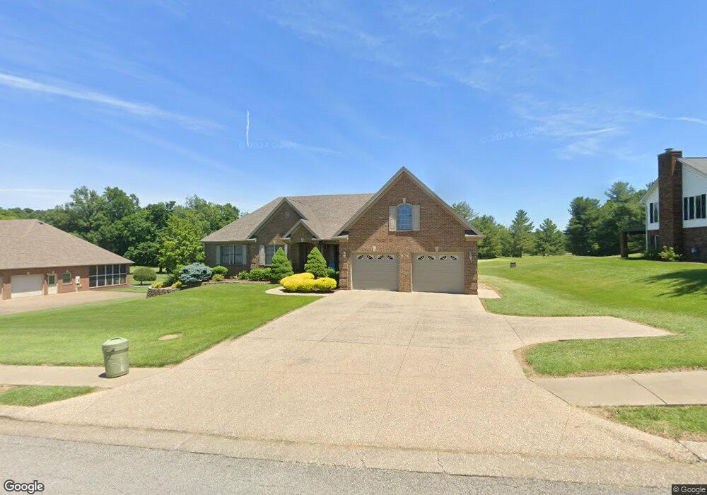
551 Saint Andrews Dr Vine Grove, KY 40175
Estimated Value: $359,408 - $418,000
3
Beds
2
Baths
2,236
Sq Ft
$174/Sq Ft
Est. Value
About This Home
This home is located at 551 Saint Andrews Dr, Vine Grove, KY 40175 and is currently estimated at $389,602, approximately $174 per square foot. 551 Saint Andrews Dr is a home located in Hardin County with nearby schools including Vine Grove Elementary School, James T. Alton Middle School, and North Hardin High School.
Ownership History
Date
Name
Owned For
Owner Type
Purchase Details
Closed on
Jun 29, 2020
Sold by
Dixic Stock Farm Sonora Inc
Bought by
Mackey Herbert and Mackey Vera
Current Estimated Value
Purchase Details
Closed on
Jun 18, 2020
Sold by
Mackey Herbert and Mackey Vera
Bought by
Cecil Michael D and Cecil Susan M
Purchase Details
Closed on
Jul 7, 2006
Sold by
Ed Cecil Construction Inc
Bought by
Cecil Michael D and Cecil Susan M
Create a Home Valuation Report for This Property
The Home Valuation Report is an in-depth analysis detailing your home's value as well as a comparison with similar homes in the area
Home Values in the Area
Average Home Value in this Area
Purchase History
| Date | Buyer | Sale Price | Title Company |
|---|---|---|---|
| Mackey Herbert | $32,000 | None Available | |
| Cecil Michael D | $32,000 | None Available | |
| Cecil Michael D | $249,500 | None Available |
Source: Public Records
Tax History Compared to Growth
Tax History
| Year | Tax Paid | Tax Assessment Tax Assessment Total Assessment is a certain percentage of the fair market value that is determined by local assessors to be the total taxable value of land and additions on the property. | Land | Improvement |
|---|---|---|---|---|
| 2024 | $2,523 | $317,000 | $47,900 | $269,100 |
| 2023 | $2,934 | $317,000 | $47,900 | $269,100 |
| 2022 | $2,603 | $317,000 | $47,900 | $269,100 |
| 2021 | $2,536 | $270,100 | $47,900 | $222,200 |
| 2020 | $2,571 | $270,100 | $47,900 | $222,200 |
| 2019 | $0 | $230,800 | $0 | $0 |
| 2018 | $2,528 | $232,500 | $0 | $0 |
| 2017 | $2,359 | $218,000 | $0 | $0 |
| 2016 | $0 | $218,700 | $0 | $0 |
| 2015 | $1,918 | $218,700 | $0 | $0 |
| 2012 | -- | $255,600 | $0 | $0 |
Source: Public Records
Map
Nearby Homes
- Lot 83 Pebble Beach Ct
- Lot 82 Pebble Beach Ct
- Lot 84 Pebble Beach Ct
- 586 Pinehurst Dr
- 584 Pinehurst Dr
- 578 Pinehurst Dr
- 580 Pinehurst Dr
- 589 Pinehurst Dr
- 587 Pinehurst Dr
- 585 Pinehurst Dr
- KINGSTON Plan at The Landings
- DUPONT Plan at The Landings
- ESSEX Plan at The Landings
- ABERNATHY Plan at The Landings
- 576 Pinehurst Dr
- 579 Pinehurst Dr
- 577 Pinehurst Dr
- 575 Pinehurst Dr
- 561 Pinehurst Dr
- 557 Pinehurst Dr
- 548 Saint Andrews Dr Unit 1
- 553 Saint Andrews Dr
- 548-2 Saint Andrews Dr
- 549 Saint Andrews Dr
- 548-1 Saint Andrews Dr
- 548-1 St Andrews Dr
- 546-2 Saint Andrews Dr
- 555 St Andrews
- 555 St Andrews Unit St. Andrews Dr.
- 555 Saint Andrews Dr
- 554 Saint Andrews Dr
- 546-1 Saint Andrews Dr
- 547-1 Saint Andrews Dr
- 547-2 Saint Andrews Dr
- 545-2 Saint Andrews Dr
- 557 St Andrews
- 557 Saint Andrews Dr
- 545-1 Saint Andrews Dr
- 702 Augusta Dr
- 556 Saint Andrews Dr