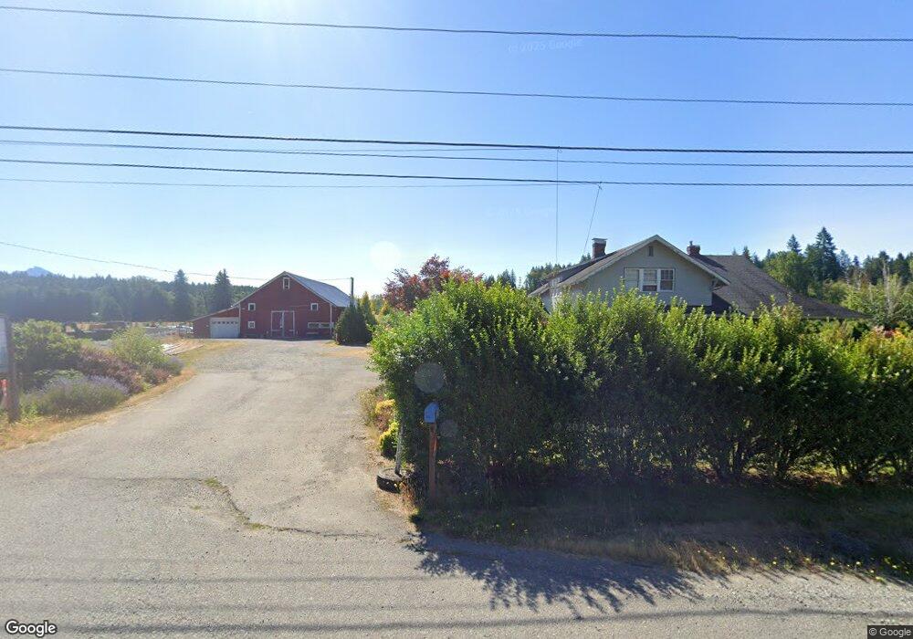
5511 State Route 92 Lake Stevens, WA 98258
Lochsloy NeighborhoodEstimated Value: $1,220,000 - $1,272,000
5
Beds
1
Bath
3,310
Sq Ft
$377/Sq Ft
Est. Value
About This Home
This home is located at 5511 State Route 92, Lake Stevens, WA 98258 and is currently estimated at $1,246,814, approximately $376 per square foot. 5511 State Route 92 is a home located in Snohomish County with nearby schools including Mt. Pilchuck Elementary School, North Lake Middle School, and Cavelero Mid High School.
Ownership History
Date
Name
Owned For
Owner Type
Purchase Details
Closed on
Oct 3, 2023
Sold by
Peters Michael J and Peters Sheila
Bought by
King George Stanford and King Dixie Dee
Current Estimated Value
Home Financials for this Owner
Home Financials are based on the most recent Mortgage that was taken out on this home.
Original Mortgage
$1,195,000
Outstanding Balance
$1,171,766
Interest Rate
7.18%
Mortgage Type
Seller Take Back
Estimated Equity
$75,048
Create a Home Valuation Report for This Property
The Home Valuation Report is an in-depth analysis detailing your home's value as well as a comparison with similar homes in the area
Home Values in the Area
Average Home Value in this Area
Purchase History
| Date | Buyer | Sale Price | Title Company |
|---|---|---|---|
| King George Stanford | $1,190,000 | Chicago Title |
Source: Public Records
Mortgage History
| Date | Status | Borrower | Loan Amount |
|---|---|---|---|
| Open | King George Stanford | $1,195,000 |
Source: Public Records
Tax History Compared to Growth
Tax History
| Year | Tax Paid | Tax Assessment Tax Assessment Total Assessment is a certain percentage of the fair market value that is determined by local assessors to be the total taxable value of land and additions on the property. | Land | Improvement |
|---|---|---|---|---|
| 2025 | $8,341 | $1,026,700 | $516,500 | $510,200 |
| 2024 | $8,341 | $920,800 | $497,200 | $423,600 |
| 2023 | $8,255 | $991,400 | $521,000 | $470,400 |
| 2022 | $7,855 | $778,600 | $395,000 | $383,600 |
| 2020 | $6,206 | $573,300 | $312,200 | $261,100 |
| 2019 | $6,090 | $556,200 | $307,700 | $248,500 |
| 2018 | $5,761 | $471,200 | $235,700 | $235,500 |
| 2017 | $5,335 | $494,100 | $277,000 | $217,100 |
| 2016 | $5,025 | $431,800 | $221,800 | $210,000 |
| 2015 | $5,035 | $402,900 | $217,800 | $185,100 |
| 2013 | $5,604 | $389,600 | $221,800 | $167,800 |
Source: Public Records
Map
Nearby Homes
- 14226 44th St NE
- 14823 43rd Place NE
- 4105 147th Ave NE
- 7222 150th Dr NE
- 7412 143rd Ave NE
- 3412 147th Ave NE
- 6714 123rd Ave NE
- 12611 37th Place NE
- 8011 Fir Tree Ln
- 4317 121st Dr NE
- 3114 159th Ave NE
- 8304 160th Dr NE
- 11217 60th St NE
- 12829 27th Place NE
- 12203 30th St NE
- 12101 30th St NE
- 12515 84th St NE
- 11608 34th St NE
- 11335 36th St NE
- 17616 72nd St NE
- 5532 State Route 92
- 5610 State Route 92
- 5325 State Route 92
- 5716 State Route 92
- 5724 147th Ave NE
- 5315 State Route 92
- 5312 147th Ave NE
- 5908 147th Ave NE
- 5920 State Route 92
- 5505 147th Ave NE
- 5625 147th Ave NE
- 5318 State Route 92
- 5807 147th Ave NE
- 5711 147th Ave NE
- 6029 145th Dr NE
- 6029 145th Dr NE
- 5226 State Route 92
- 6030 145th Dr NE
- 14417 50th St NE
- 5109 147th Ave NE