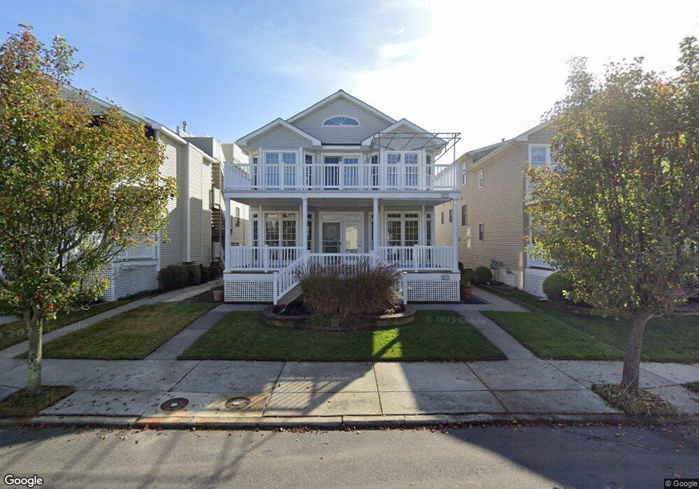
5513 Simpson Ave Unit 15 Ocean City, NJ 08226
Estimated Value: $1,428,000 - $2,214,000
--
Bed
--
Bath
3,202
Sq Ft
$613/Sq Ft
Est. Value
About This Home
This home is located at 5513 Simpson Ave Unit 15, Ocean City, NJ 08226 and is currently estimated at $1,964,042, approximately $613 per square foot. 5513 Simpson Ave Unit 15 is a home located in Cape May County with nearby schools including Ocean City Primary School, Ocean City Intermediate School, and Ocean City High School.
Ownership History
Date
Name
Owned For
Owner Type
Purchase Details
Closed on
Dec 6, 2023
Sold by
Ruth Lydia Lauro Family Trust
Bought by
Lauro Leonard F
Current Estimated Value
Purchase Details
Closed on
Mar 31, 2016
Sold by
Lauro Leonard F and Estate Of Ruth Lydia Lauro
Bought by
Leonard F Lauro And The Ruth Lyndia Fami
Purchase Details
Closed on
May 16, 1992
Sold by
Dunleavy Joseh J
Bought by
Lauro Leonard F and Lauro Rut L
Create a Home Valuation Report for This Property
The Home Valuation Report is an in-depth analysis detailing your home's value as well as a comparison with similar homes in the area
Home Values in the Area
Average Home Value in this Area
Purchase History
| Date | Buyer | Sale Price | Title Company |
|---|---|---|---|
| Lauro Leonard F | -- | None Listed On Document | |
| Lauro Leonard F | -- | None Listed On Document | |
| Leonard F Lauro And The Ruth Lyndia Fami | -- | None Available | |
| Lauro Leonard F | $148,000 | -- | |
| Lauro Leonard F | $148,000 | -- |
Source: Public Records
Tax History Compared to Growth
Tax History
| Year | Tax Paid | Tax Assessment Tax Assessment Total Assessment is a certain percentage of the fair market value that is determined by local assessors to be the total taxable value of land and additions on the property. | Land | Improvement |
|---|---|---|---|---|
| 2025 | $11,417 | $1,039,800 | $496,100 | $543,700 |
| 2024 | $11,417 | $1,039,800 | $496,100 | $543,700 |
| 2023 | $10,886 | $1,039,800 | $496,100 | $543,700 |
| 2022 | $10,450 | $1,039,800 | $496,100 | $543,700 |
| 2021 | $7,219 | $1,039,800 | $496,100 | $543,700 |
| 2020 | $9,919 | $1,039,800 | $496,100 | $543,700 |
| 2019 | $9,805 | $1,039,800 | $496,100 | $543,700 |
| 2018 | $9,711 | $1,039,800 | $496,100 | $543,700 |
| 2017 | $9,555 | $1,039,800 | $496,100 | $543,700 |
| 2016 | $9,181 | $1,039,800 | $496,100 | $543,700 |
| 2015 | $9,056 | $1,039,800 | $496,100 | $543,700 |
| 2014 | $8,921 | $1,039,800 | $496,100 | $543,700 |
Source: Public Records
Map
Nearby Homes
- 5512 Asbury Ave
- 5404 Bay Ave
- 400 E 55th St Unit D
- 400 E 55th St Unit E
- 400 E 55th St Unit F
- 216 Anchorage Dr
- 209 Bark Dr
- 305 57th St Unit 305
- 5315 West Ave
- 13 53rd St
- 5242 West Ave Unit 2
- 5225 Asbury Ave Unit 1
- 5235 Central Ave
- 5132 Central Ave
- 4933 Central Ave Unit 4933
- 4919 Central Ave
- 4923 Central Ave Unit 2
- 4828 West Ave Unit first floor
- 4818-20 Asbury Ave
- 4818 Asbury Ave Unit 1
- 5517 Simpson Ave Unit 19
- 5517 Simpson Ave Unit 19
- 5509 Simpson Ave Unit 11
- 5509 Simpson Ave Unit 11
- 5527 Simpson Ave Unit 2nd Floor
- 5505 Simpson Ave Unit 7
- 5521 Simpson Ave Unit 23
- 5525 Simpson Ave Unit 1
- 5525 Simpson Ave Unit 27
- 5525 Simpson Ave Unit 27
- 5534 Simpson Ave Unit 2
- 5530 Simpson Ave Unit 2nd Floor
- 5501 Simpson Ave Unit B
- 5501 Simpson Ave
- 5501 Simpson Ave Unit 2ND
- 5501 Simpson Ave Unit C
- 5511 Simpson Ave Unit C-2
- 5511 Simpson Ave Unit B
- 5512 Haven Ave Unit 14
- 5516 Haven Ave Unit 18