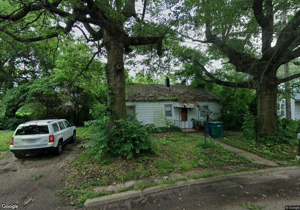
552 Circle Dr La Porte, IN 46350
Estimated Value: $118,000 - $163,000
3
Beds
1
Bath
1,032
Sq Ft
$132/Sq Ft
Est. Value
About This Home
This home is located at 552 Circle Dr, La Porte, IN 46350 and is currently estimated at $136,690, approximately $132 per square foot. 552 Circle Dr is a home located in LaPorte County with nearby schools including Dunkerton Elementary School, Handley Elementary School, and La Porte High School.
Ownership History
Date
Name
Owned For
Owner Type
Purchase Details
Closed on
Jun 21, 2007
Sold by
Levenhagen Leslie J and Levenhagen John
Bought by
Milam Shawn and Milam April
Current Estimated Value
Home Financials for this Owner
Home Financials are based on the most recent Mortgage that was taken out on this home.
Original Mortgage
$59,000
Outstanding Balance
$36,121
Interest Rate
6.2%
Mortgage Type
Unknown
Estimated Equity
$100,569
Create a Home Valuation Report for This Property
The Home Valuation Report is an in-depth analysis detailing your home's value as well as a comparison with similar homes in the area
Home Values in the Area
Average Home Value in this Area
Purchase History
| Date | Buyer | Sale Price | Title Company |
|---|---|---|---|
| Milam Shawn | -- | Meridian Title Corp |
Source: Public Records
Mortgage History
| Date | Status | Borrower | Loan Amount |
|---|---|---|---|
| Open | Milam Shawn | $59,000 |
Source: Public Records
Tax History Compared to Growth
Tax History
| Year | Tax Paid | Tax Assessment Tax Assessment Total Assessment is a certain percentage of the fair market value that is determined by local assessors to be the total taxable value of land and additions on the property. | Land | Improvement |
|---|---|---|---|---|
| 2024 | $761 | $30,300 | $7,600 | $22,700 |
| 2023 | $610 | $30,300 | $7,600 | $22,700 |
| 2022 | $594 | $31,400 | $7,600 | $23,800 |
| 2021 | $594 | $29,500 | $7,600 | $21,900 |
| 2020 | $594 | $29,500 | $7,600 | $21,900 |
| 2019 | $690 | $29,500 | $7,600 | $21,900 |
| 2018 | $690 | $29,500 | $7,600 | $21,900 |
| 2017 | $1,260 | $57,900 | $20,300 | $37,600 |
| 2016 | $1,107 | $50,300 | $17,700 | $32,600 |
| 2014 | $992 | $49,300 | $17,700 | $31,600 |
Source: Public Records
Map
Nearby Homes
- 512 Circle Dr
- 548 Circle Dr
- 131 Regency Pkwy
- 129 Regency Pkwy
- 556 Circle Dr
- 127 Regency Pkwy
- 545 Circle Dr
- 544 Circle Dr
- 546 Circle Dr
- 521 Circle Dr
- 560 Circle Dr
- 125 Regency Pkwy
- 540 Circle Dr Unit 542
- 1504 D St
- 513 Circle Dr
- 513 Circle Dr Unit 1&2
- 511 Circle Dr Unit 1&2
- 133 Regency Pkwy
- 1401 Federal Ave
- 123 Regency Pkwy